University of Sunderland - Travel Plan Final 200510-1
University of Sunderland - Travel Plan Final 200510-1
University of Sunderland - Travel Plan Final 200510-1

You also want an ePaper? Increase the reach of your titles
YUMPU automatically turns print PDFs into web optimized ePapers that Google loves.
<strong>University</strong> <strong>of</strong> <strong>Sunderland</strong> <strong>Travel</strong> <strong>Plan</strong> Update<br />
• New cycle surface added ffrom<br />
rom Castletown to east Southwick, including anti anti-slip surfaces on<br />
inclines, tarmac and street lighting through the Southwick Gyratory; and<br />
• A north / south cycle route created between Southwick town centre and Pallion, plus<br />
formalised cycle use on the Queen Alexandra Bridge.<br />
Walking<br />
Pedestrians and cyclists can also use the underpass beneath<br />
the A1231 St Michael’s Way, which links the City Campus (Murray Library area) with the city<br />
centre and the Priestman Building Building. The underpass is generally well used, , maintained and lit.<br />
Additionally, , there are crossing facilities at the A183 Chester Road / A1231 St Michael’s Way<br />
junction.<br />
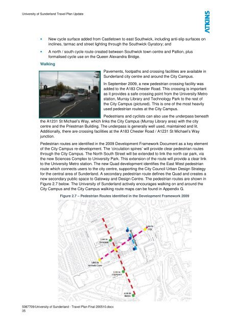
Pedestrian routes are identified in the 2009 Development Framework Document as a key element<br />
<strong>of</strong> the City Campus re-development. development. The ‘circu ‘circulation lation spines’ will provide clear pedestrian routes<br />
through the City Campus. The North South Street will be extended to link the north car park, via<br />
the new Sciences Complex to <strong>University</strong> Park. This extension <strong>of</strong> the route will provide a clear li link<br />
to the <strong>University</strong> Metro station. The new Quad development identifies the East West pedestrian<br />
route which connects users to the city centre, supporting the City Council Urban Design Strategy<br />
for the central area <strong>of</strong> <strong>Sunderland</strong>. A secondary pedestrian rou route te defines the Quad and creates a<br />
new secondary public space to Gateway and Design Centre. The pedestrian route routes are shown in<br />
Figure 2.7 below. The <strong>University</strong> <strong>of</strong> <strong>Sunderland</strong> actively encourages walking on and around the<br />
City Campus and the City Campus walking route maps can be found in Appendix GG.<br />
Figure 2.7 – Pedestrian Routes identified in the Development Framework 2009<br />
5087709/<strong>University</strong> <strong>of</strong> <strong>Sunderland</strong> - <strong>Travel</strong> <strong>Plan</strong> <strong>Final</strong> <strong>200510</strong>.docx<br />
35<br />
Pavements, footpaths and crossing facilities are available in<br />
<strong>Sunderland</strong> city centre and around the City Campus.<br />
In September 2009, a new pedestrian crossing facility was<br />
added to the A183 Chester Road. This crossing is important<br />
as it provides a safe crossing point from the <strong>University</strong> Metro<br />
station, Murray Library and Technology Park to the rest <strong>of</strong><br />
the City Campus (pictured). This is one <strong>of</strong> the most heavily<br />
used pedestrian routes at the City ty Campus.