Cortina Inverno
Eccoci arrivati al decimo numero di CORTINA.TOPic. Una bella strada, quella che abbiamo percorso assieme. Con un obiettivo interessante, quello di dar vita — cinque stagioni or sono — a una rivista dalla doppia vocazione: di approfondimento e promozione, capace di immortalare la Cortina che ci piace e di dar voce a chi la ama, guardando sempre al futuro, forti di un illustre passato.
Eccoci arrivati al decimo numero di CORTINA.TOPic.
Una bella strada, quella che abbiamo percorso assieme. Con
un obiettivo interessante, quello di dar vita — cinque stagioni
or sono — a una rivista dalla doppia vocazione: di approfondimento
e promozione, capace di immortalare la Cortina che
ci piace e di dar voce a chi la ama, guardando sempre al futuro, forti di un
illustre passato.

You also want an ePaper? Increase the reach of your titles
YUMPU automatically turns print PDFs into web optimized ePapers that Google loves.
66<br />
When the<br />
map is the<br />
treasure<br />
I<br />
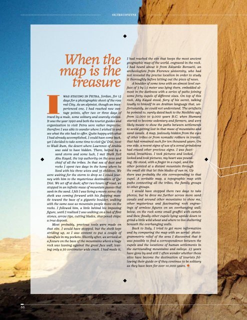
was staying in Petra, Jordan, for 12<br />
days for a photographic shoot of the rose<br />
red City. As an alpinist, though an inexperienced<br />
one, I had reached new vantage<br />
points, after two or three days of<br />
travel by a mule, some solitary and scarcely visited.<br />
It was the year 1990 and both the tourist guides and<br />
organization to visit Petra were rather imprecise;<br />
therefore I was able to wander where I wished to and<br />
see what the site had to offer. Quite happy with what<br />
I had already accomplished, I could have come back,<br />
yet I decided to take some time to visit Qa’ Disi, next<br />
to Wadi Rum, the desert where Lawrence of Arabia<br />
was said to have hidden. There, helped by a<br />
sand storm and some luck, I met Sheik Jleil<br />
Abu Kayed, the top authority on the area and<br />
chief of all the tribes. In that sea of dust and<br />
rocks I spent two days in the home where he<br />
lived with his three wives and 35 children. We<br />
were waiting for the storm to drop so I could journey<br />
with him to the mysterious destination of Qa’<br />
Disi. We set off at dusk; after two hours off road, we<br />
stopped in an infinite maze of mountain passes that<br />
sank in the sand. I felt I was living a movie scene: the<br />
sheik was coming forward with his flapping mantle<br />
toward the base of a gigantic boulder, walking<br />
with the same ease as mountain people move on the<br />
rocks. I followed him, a little behind his imposing<br />
figure, until I realized I was walking on a bed of flint<br />
stones, arrow tips, cutting blades, sharpened chips:<br />
a true deposit.<br />
Most probably, precious tools were made on<br />
that site. I would have stopped, but the sheik kept<br />
striding up, so I was content to put a couple of<br />
handfuls in my pockets. Shortly after, we arrived at<br />
a fissure on the base of the mountains where a huge<br />
rock was leaning against the great face wall, leaving<br />
only a 50 centimeter wide crack. I had made it,<br />
oltreconFine<br />
I had reached the site that keeps the most ancient<br />
geographic map of the world, engraved in the rock.<br />
I had heard about it from Edoardo Borzatti, an<br />
archeologists from Florence university, who had<br />
not revealed the precise location in order to study<br />
it thoroughly before letting out the piece of news.<br />
A boulder of some tons with an almost level surface<br />
of 3 by 1.5 meter was lying there, embedded almost<br />
in the darkness with a series of paths joining<br />
some forty cupels of different sizes. On top of this<br />
rock, Aby Kayed stood, fiery of his secret, talking<br />
loudly to himself in an Arabian language that, unfortunately,<br />
we could not understand. The artefacts<br />
he pointed to, surely dated back to the Neolithic age,<br />
from 12,000 to 9,000 years B.C. when Humans<br />
started to become sedentary and farmers, and were<br />
likely meant to show the paths between settlements<br />
to avoid getting lost in that maze of mountains and<br />
sand canals. A map, jealously hidden from the eyes<br />
of other tribes or from nomadic robbers in transit,<br />
that had remained such for ten thousand years. On<br />
one side, a recent signs of use of a cereal grindstone<br />
had erased other precious signs. I was fascinated,<br />
breathless. I took pictures and looked,<br />
looked and took pictures, my heart was pounding.<br />
He stood, with a finger in a cupel, and the<br />
other pointed at a distant mountain through<br />
the small slit that let thin blades of sun in. Up<br />
there was probably the site corresponding to that<br />
cupel. A veritable map, a topographic map with<br />
paths connecting all the tribes, the family groups<br />
to other groups.<br />
I would have stopped there two days to take<br />
photos, but he drew me further across more sand<br />
canals and around other mountains to show me,<br />
other mysterious and fascinating rock engravings<br />
of armless figures on an overhanging wall;<br />
below, on the rock some small graffiti with camels<br />
and ibex; finally other cupels lying upside down to<br />
grind a little wild wheat and where to live sheltering<br />
beneath the overhanging walls.<br />
Back to Italy, I tried to get more information<br />
and by comparing the map with an aerial- photogrammetric<br />
relief of the area I discovered that it<br />
was possible to find a correspondence between the<br />
cupels and the locations of human settlements in<br />
the surrounding mountains and valleys. 23 years<br />
have gone by and still I often wonder whether those<br />
sites have become the destination of tourists following<br />
their guide or if they continue to be solitary<br />
as they have been for over 10,000 years.