2012 COURSE DATES: AUGUST 4 – 17, 2012 - Sirenian International
2012 COURSE DATES: AUGUST 4 – 17, 2012 - Sirenian International
2012 COURSE DATES: AUGUST 4 – 17, 2012 - Sirenian International

Create successful ePaper yourself
Turn your PDF publications into a flip-book with our unique Google optimized e-Paper software.
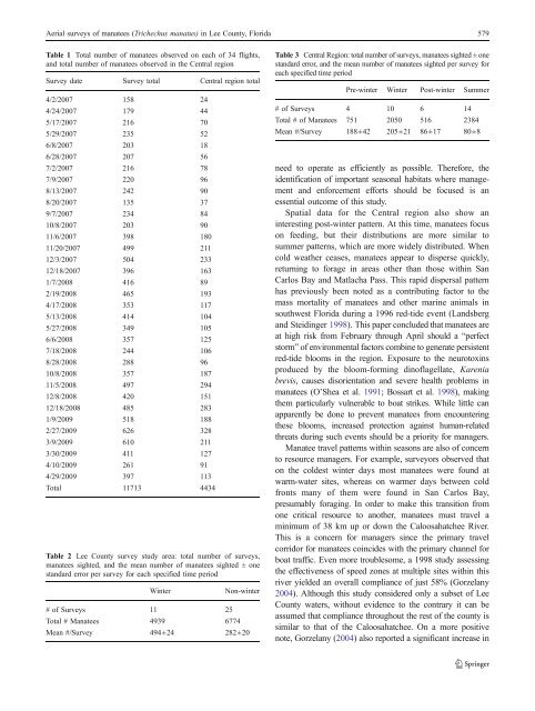
Aerial surveys of manatees (Trichechus manatus) in Lee County, Florida 579<br />
Table 1 Total number of manatees observed on each of 34 flights,<br />
and total number of manatees observed in the Central region<br />
Survey date Survey total Central region total<br />
4/2/2007 158 24<br />
4/24/2007 <strong>17</strong>9 44<br />
5/<strong>17</strong>/2007 216 70<br />
5/29/2007 235 52<br />
6/8/2007 203 18<br />
6/28/2007 207 56<br />
7/2/2007 216 78<br />
7/9/2007 220 96<br />
8/13/2007 242 90<br />
8/20/2007 135 37<br />
9/7/2007 234 84<br />
10/8/2007 203 90<br />
11/6/2007 398 180<br />
11/20/2007 499 211<br />
12/3/2007 504 233<br />
12/18/2007 396 163<br />
1/7/2008 416 89<br />
2/19/2008 465 193<br />
4/<strong>17</strong>/2008 353 1<strong>17</strong><br />
5/13/2008 414 104<br />
5/27/2008 349 105<br />
6/6/2008 357 125<br />
7/18/2008 244 106<br />
8/28/2008 288 96<br />
10/8/2008 357 187<br />
11/5/2008 497 294<br />
12/8/2008 420 151<br />
12/18/2008 485 283<br />
1/9/2009 518 188<br />
2/27/2009 626 328<br />
3/9/2009 610 211<br />
3/30/2009 411 127<br />
4/10/2009 261 91<br />
4/29/2009 397 113<br />
Total 1<strong>17</strong>13 4434<br />
Table 2 Lee County survey study area: total number of surveys,<br />
manatees sighted, and the mean number of manatees sighted ± one<br />
standard error per survey for each specified time period<br />
Winter Non-winter<br />
# of Surveys 11 25<br />
Total # Manatees 4939 6774<br />
Mean #/Survey 494±24 282±20<br />
Table 3 Central Region: total number of surveys, manatees sighted ± one<br />
standard error, and the mean number of manatees sighted per survey for<br />
each specified time period<br />
Pre-winter Winter Post-winter Summer<br />
# of Surveys 4 10 6 14<br />
Total # of Manatees 751 2050 516 2384<br />
Mean #/Survey 188±42 205±21 86±<strong>17</strong> 80±8<br />
need to operate as efficiently as possible. Therefore, the<br />
identification of important seasonal habitats where management<br />
and enforcement efforts should be focused is an<br />
essential outcome of this study.<br />
Spatial data for the Central region also show an<br />
interesting post-winter pattern. At this time, manatees focus<br />
on feeding, but their distributions are more similar to<br />
summer patterns, which are more widely distributed. When<br />
cold weather ceases, manatees appear to disperse quickly,<br />
returning to forage in areas other than those within San<br />
Carlos Bay and Matlacha Pass. This rapid dispersal pattern<br />
has previously been noted as a contributing factor to the<br />
mass mortality of manatees and other marine animals in<br />
southwest Florida during a 1996 red-tide event (Landsberg<br />
and Steidinger 1998). This paper concluded that manatees are<br />
at high risk from February through April should a “perfect<br />
storm” of environmental factors combine to generate persistent<br />
red-tide blooms in the region. Exposure to the neurotoxins<br />
produced by the bloom-forming dinoflagellate, Karenia<br />
brevis, causes disorientation and severe health problems in<br />
manatees (O’Shea et al. 1991; Bossart et al. 1998), making<br />
them particularly vulnerable to boat strikes. While little can<br />
apparently be done to prevent manatees from encountering<br />
these blooms, increased protection against human-related<br />
threats during such events should be a priority for managers.<br />
Manatee travel patterns within seasons are also of concern<br />
to resource managers. For example, surveyors observed that<br />
on the coldest winter days most manatees were found at<br />
warm-water sites, whereas on warmer days between cold<br />
fronts many of them were found in San Carlos Bay,<br />
presumably foraging. In order to make this transition from<br />
one critical resource to another, manatees must travel a<br />
minimum of 38 km up or down the Caloosahatchee River.<br />
This is a concern for managers since the primary travel<br />
corridor for manatees coincides with the primary channel for<br />
boat traffic. Even more troublesome, a 1998 study assessing<br />
the effectiveness of speed zones at multiple sites within this<br />
river yielded an overall compliance of just 58% (Gorzelany<br />
2004). Although this study considered only a subset of Lee<br />
County waters, without evidence to the contrary it can be<br />
assumed that compliance throughout the rest of the county is<br />
similar to that of the Caloosahatchee. On a more positive<br />
note, Gorzelany (2004) also reported a significant increase in