Proceedings - Balai Penelitian Tanah
Proceedings - Balai Penelitian Tanah
Proceedings - Balai Penelitian Tanah

Create successful ePaper yourself
Turn your PDF publications into a flip-book with our unique Google optimized e-Paper software.
3<br />
Harjadi PJP<br />
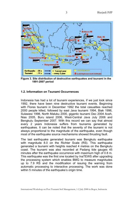
Figure 3. Site distribution of destructive earthquakes and tsunami in the<br />
1991-2007 period<br />
1.2. Information on Tsunami Occurrences<br />
Indonesia has had a lot of tsunami experiences, if we just look since<br />
1992, there have been nine destructive tsunami events. Beginning<br />
with Flores tsunami in December 1992 the total casualties reached<br />
2000 people killed, followed by east Java tsunami 1994, Biak 1996,<br />
Sulawesi 1998, North Maluku 2000, gigantic tsunami Dec 2004 Aceh,<br />
Nias 2005, Buru island 2006, West-Central Java July 2006 and<br />
Bengkulu September 2007. With this record we can say that almost<br />
every 2 years Indonesia suffers from tsunamis generated by<br />
earthquakes. It can be noted that the severity of the tsunami is not<br />
always proportional to the magnitude of the earthquake, even though<br />
most of the earthquake source mechanisms showed thrusting fault.<br />
The last earthquake generated tsunami was Bengkulu earthquake<br />
with magnitude 8.0 on the Richter Scale (RS). This earthquake<br />
generated a tsunami with heights reached 4 metres on the Bengkulu<br />
coast. The tsunami was also recorded at Padang tide gauges 45<br />
minutes after the earthquake occurrence with maximum high of 0.8 m.<br />
This earthquake was the first one located by InaTEWS after upgrading<br />
the processing system which enables BMG to measure magnitudes<br />
up to 7.9 RS and the modification of issuing the warning from<br />
automatic processing to interactive processing. The work was done<br />
within 5 minutes of the earthquake’s origin time.<br />
International Workshop on Post Tsunami Soil Management, 1-2 July 2008 in Bogor, Indonesia