Naylor Road Metro Station Area Access and Capacity - WMATA.com.
Naylor Road Metro Station Area Access and Capacity - WMATA.com.
Naylor Road Metro Station Area Access and Capacity - WMATA.com.

Create successful ePaper yourself
Turn your PDF publications into a flip-book with our unique Google optimized e-Paper software.
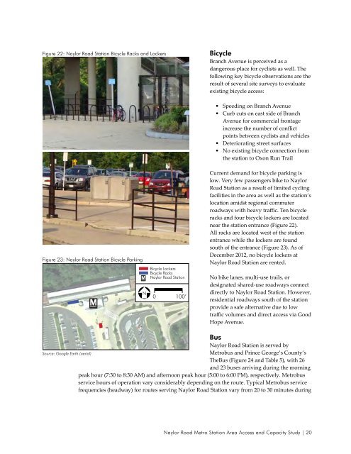
Figure 22: <strong>Naylor</strong> <strong>Road</strong> <strong>Station</strong> Bicycle Racks <strong>and</strong> Lockers<br />
Bicycle<br />
Branch Avenue is perceived as a<br />
dangerous place for cyclists as well. The<br />
following key bicycle observations are the<br />
result of several site surveys to evaluate<br />
existing bicycle access:<br />
• Speeding on Branch Avenue<br />
• Curb cuts on east side of Branch<br />
Avenue for <strong>com</strong>mercial frontage<br />
increase the number of conflict<br />
points between cyclists <strong>and</strong> vehicles<br />
• Deteriorating street surfaces<br />
• No existing bicycle connection from<br />
the station to Oxon Run Trail<br />
Figure 23: <strong>Naylor</strong> <strong>Road</strong> <strong>Station</strong> Bicycle Parking<br />
Bicycle Lockers<br />
Bicycle Racks<br />
<strong>Naylor</strong> <strong>Road</strong> <strong>Station</strong><br />
N 0 100’<br />
Current dem<strong>and</strong> for bicycle parking is<br />
low. Very few passengers bike to <strong>Naylor</strong><br />
<strong>Road</strong> <strong>Station</strong> as a result of limited cycling<br />
facilities in the area as well as the station’s<br />
location amidst regional <strong>com</strong>muter<br />
roadways with heavy traffic. Ten bicycle<br />
racks <strong>and</strong> four bicycle lockers are located<br />
near the station entrance (Figure 22).<br />
All racks are located west of the station<br />
entrance while the lockers are found<br />
south of the entrance (Figure 23). As of<br />
December 2012, no bicycle lockers at<br />
<strong>Naylor</strong> <strong>Road</strong> <strong>Station</strong> are rented.<br />
No bike lanes, multi-use trails, or<br />
designated shared-use roadways connect<br />
directly to <strong>Naylor</strong> <strong>Road</strong> <strong>Station</strong>. However,<br />
residential roadways south of the station<br />
provide a safe alternative due to low<br />
traffic volumes <strong>and</strong> direct access via Good<br />
Hope Avenue.<br />
Source: Google Earth (aerial)<br />
Bus<br />
<strong>Naylor</strong> <strong>Road</strong> <strong>Station</strong> is served by<br />
<strong>Metro</strong>bus <strong>and</strong> Prince George’s County’s<br />
TheBus (Figure 24 <strong>and</strong> Table 5), with 26<br />
<strong>and</strong> 23 buses arriving during the morning<br />
peak hour (7:30 to 8:30 AM) <strong>and</strong> afternoon peak hour (5:00 to 6:00 PM), respectively. <strong>Metro</strong>bus<br />
service hours of operation vary considerably depending on the route. Typical <strong>Metro</strong>bus service<br />
frequencies (headway) for routes serving <strong>Naylor</strong> <strong>Road</strong> <strong>Station</strong> vary from 20 to 30 minutes during<br />
<strong>Naylor</strong> <strong>Road</strong> <strong>Metro</strong> <strong>Station</strong> <strong>Area</strong> <strong>Access</strong> <strong>and</strong> <strong>Capacity</strong> Study | 20