Naylor Road Metro Station Area Access and Capacity - WMATA.com.
Naylor Road Metro Station Area Access and Capacity - WMATA.com.
Naylor Road Metro Station Area Access and Capacity - WMATA.com.

Create successful ePaper yourself
Turn your PDF publications into a flip-book with our unique Google optimized e-Paper software.
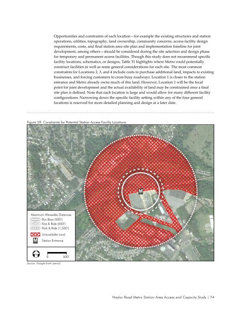
Opportunities <strong>and</strong> constraints of each location—for example the existing structures <strong>and</strong> station<br />
operations, utilities, topography, l<strong>and</strong> ownership, <strong>com</strong>munity concerns, access facility design<br />
requirements, costs, <strong>and</strong> final station area site plan <strong>and</strong> implementation timeline for joint<br />
development, among others—should be considered during the site selection <strong>and</strong> design phase<br />
for temporary <strong>and</strong> permanent access facilities. Though this study does not re<strong>com</strong>mend specific<br />
facility locations, schematics, or designs, Table 31 highlights where <strong>Metro</strong> could potentially<br />
construct facilities as well as some general considerations for each site. The most <strong>com</strong>mon<br />
constraints for Locations 2, 3, <strong>and</strong> 4 include costs to purchase additional l<strong>and</strong>, impacts to existing<br />
businesses, <strong>and</strong> forcing customers to cross busy roadways. Location 1 is closer to the station<br />
entrance <strong>and</strong> <strong>Metro</strong> already owns much of this l<strong>and</strong>. However, Location 1 will be the focal<br />
point for joint development <strong>and</strong> the actual availability of l<strong>and</strong> may be constrained once a final<br />
site plan is defined. Note that each location is large <strong>and</strong> would allow for many different facility<br />
configurations. Narrowing down the specific facility setting within any of the four general<br />
locations is reserved for more detailed planning <strong>and</strong> design at a later date.<br />
Figure 59: Constraints for Potential <strong>Station</strong> <strong>Access</strong> Facility Locations<br />
<strong>Naylor</strong> Rd<br />
Suitl<strong>and</strong> Pkwy<br />
Southern Ave<br />
Maximum Allowable Distances<br />
Bus Bays (500’)<br />
Kiss & Ride (600’)<br />
Park & Ride (1,500’)<br />
Unavailable L<strong>and</strong><br />
<strong>Station</strong> Entrance<br />
Oxon Run Dr<br />
<strong>Naylor</strong> Rd<br />
Branch Ave<br />
N<br />
0 500’<br />
Source: Google Earth (aerial)<br />
<strong>Naylor</strong> <strong>Road</strong> <strong>Metro</strong> <strong>Station</strong> <strong>Area</strong> <strong>Access</strong> <strong>and</strong> <strong>Capacity</strong> Study | 74