
You also want an ePaper? Increase the reach of your titles
YUMPU automatically turns print PDFs into web optimized ePapers that Google loves.
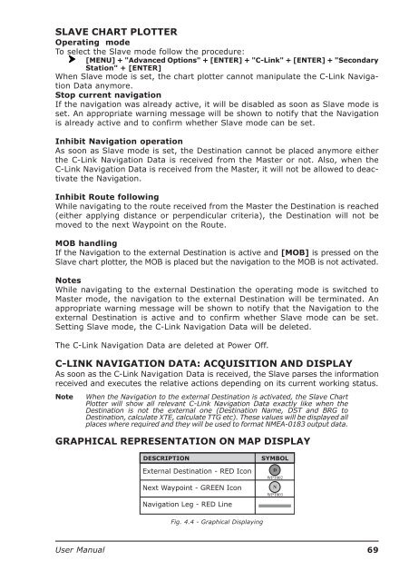
SLAVE CHART PLOTTEROperating modeTo select the Slave mode follow the procedure:[MENU] + "Advanced Options" + [ENTER] + "C-Link" + [ENTER] + "SecondaryStation" + [ENTER]When Slave mode is set, the chart plotter cannot manipulate the C-Link NavigationData anymore.Stop current navigationIf the navigation was already active, it will be disabled as soon as Slave mode isset. An appropriate warning message will be shown to notify that the Navigationis already active and to confirm whether Slave mode can be set.Inhibit Navigation operationAs soon as Slave mode is set, the Destination cannot be placed anymore eitherthe C-Link Navigation Data is received from the Master or not. Also, when theC-Link Navigation Data is received from the Master, it will not be allowed to deactivatethe Navigation.Inhibit Route followingWhile navigating to the route received from the Master the Destination is reached(either applying distance or perpendicular criteria), the Destination will not bemoved to the next Waypoint on the Route.MOB handlingIf the Navigation to the external Destination is active and [MOB] is pressed on theSlave chart plotter, the MOB is placed but the navigation to the MOB is not activated.NotesWhile navigating to the external Destination the operating mode is switched toMaster mode, the navigation to the external Destination will be terminated. Anappropriate warning message will be shown to notify that the Navigation to theexternal Destination is active and to confirm whether Slave mode can be set.Setting Slave mode, the C-Link Navigation Data will be deleted.The C-Link Navigation Data are deleted at Power Off.C-LINK NAVIGATION DATA: ACQUISITION AND DISPLAYAs soon as the C-Link Navigation Data is received, the Slave parses the informationreceived and executes the relative actions depending on its current working status.NoteWhen the Navigation to the external Destination is activated, the Slave ChartPlotter will show all relevant C-Link Navigation Data exactly like when theDestination is not the external one (Destination Name, DST and BRG toDestination, calculate XTE, calculate TTG etc). These values will be displayed allplaces where required and they will be used to format NMEA-0183 output data.GRAPHICAL REPRESENTATION ON MAP DISPLAYFig. 4.4 - Graphical Displaying<strong>User</strong> <strong>Manual</strong>69