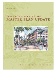
Master Plan Development - City of Boca Raton
Master Plan Development - City of Boca Raton
Master Plan Development - City of Boca Raton

You also want an ePaper? Increase the reach of your titles
YUMPU automatically turns print PDFs into web optimized ePapers that Google loves.
<strong>City</strong> <strong>of</strong> <strong>Boca</strong> <strong>Raton</strong> Stormwater Management <strong>Master</strong> <strong>Plan</strong>Drainage Basin3. Drainage BasinIn general, current stormwater management policies rely heavily on a watershed or drainage basinapproach. Historically, the <strong>City</strong> has been interested in five major watersheds associated with thefollowing water bodies: The C-15 Canal, the Hillsboro Canal, the E-3 Canal, the E-4 Canal, andthe ICWW. Several drainage basin delineations have previously been made: specifically, thosedone by SFWMD and DEP. In addition, drainage basins were established when the original MS4NPDES permit application was made in the early 1990s. The watershed boundaries do notcoincide with one another. Therefore, with the information currently available, updated basindelineations have been made for the five major watersheds within the <strong>City</strong>.A. Basin DelineationsSFWMD permits, FDOT and PBC project construction drawings, the GIS coverage <strong>of</strong> the <strong>City</strong>’sstormwater system, aerial photographs, terrain elevations, and the LWDD Elevation Map were allused as sources <strong>of</strong> information to define the five major drainage basins within the <strong>City</strong>.ICWW WatershedThe ICWW is a tidally influenced water body. Any system that discharges into the ICWW or anuncontrolled tributary <strong>of</strong> it is considered part <strong>of</strong> its drainage area. While this is somewhatconsistent with the DEP drainage delineations, it varies from SFWMD and the previous NPDESdelineations. The decision behind the chosen delineation is that the Hillsboro Canal controlstructure (G-56) is west <strong>of</strong> the E-3 Canal. This means that, like the ICWW, the Canal east <strong>of</strong> thestructure and any tributary discharging into it, are tidally influenced; essentially one with ICWW.The ICWW drainage basin includes those drainage areas that discharge into any canal, or portionthere<strong>of</strong>, that is tidally influenced. Similarly, areas discharging to the C-15 downstream <strong>of</strong> itscontrol structure (S-40) are considered part <strong>of</strong> the ICWW drainage basin.E-3 WatershedThe E-3 Canal discharges to the Hillsboro Canal, however, its water level is controlled by acontrol structure (CS No.16) near the confluence with the Hillsboro Canal. The E-3 Basinincludes all the drainage areas discharging into LWDD L-43 to L-50 Canals, west <strong>of</strong> MilitaryTrail, or those that discharge directly to the E-3 Canal south <strong>of</strong> Yamato Road.E-4 WatershedThe E-4 Canal also discharges to the Hillsboro Canal downstream <strong>of</strong> the G-56 structure. Areasdraining to the portion <strong>of</strong> the E-4 Canal south <strong>of</strong> the salinity structure are in the ICWW drainagebasin. The E-4 drainage basin includes all the drainage areas that discharge into LWDD L-40 toL-46 Canals, east <strong>of</strong> Military Trail, or those that discharge directly to the E-4 between ControlStructure No. 15 (near the <strong>City</strong>’s northern limits) and the salinity control structure north <strong>of</strong> GladesRoad.L/bocaswmp/a6016.01/InterimReport 11-27-07/r02Page 9MOCK•ROOS