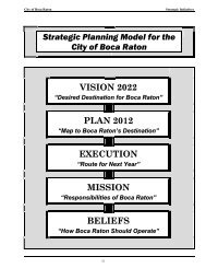
Master Plan Development - City of Boca Raton
Master Plan Development - City of Boca Raton
Master Plan Development - City of Boca Raton

You also want an ePaper? Increase the reach of your titles
YUMPU automatically turns print PDFs into web optimized ePapers that Google loves.
<strong>City</strong> <strong>of</strong> <strong>Boca</strong> <strong>Raton</strong> Stormwater Management <strong>Master</strong> <strong>Plan</strong>Other Relevant Data4. Other Relevant DataA. High Risk FacilitiesThe <strong>City</strong>’s MS4 NPDES permit requires that it “identify and control pollutants in stormwaterdischarges to the MS4 from any municipal landfill(s); hazardous waste treatment, storage,disposal and recovery facilities; facilities that are subject to EPCRA [Emergency <strong>Plan</strong>ning andCommunity Right-to-know Act] Title III, Section 313; and any other industrial or commercialdischarge which the permittee(s) determine is contributing, or has the potential to contribute, asubstantial pollutant loading to the MS4.” 3 The permit further requires that in addition toidentifying facilities, the <strong>City</strong> determine priority, develop a schedule for and carry outinspections.To develop the initial list <strong>of</strong> potential high risk facilities, both the EPA Envir<strong>of</strong>acts Database(http://www.epa.gov/enviro/) and the DEP Solid Waste Database(http://ca.dep.state.fl.us/imf/caFrameset.jsp?browser=IE5up) were searched to identify facilitieslocated within the <strong>City</strong> limits. The Envir<strong>of</strong>acts website allows searching <strong>of</strong> multiple informationsystems, including the Resource Conservation and Recovery Information System (RCRIS), theComprehensive Environmental Response, Compensation, and Liability Information System(“CERCLIS”) – also known as Superfund, and the Toxic Release Inventory System (“TRIS”).It has been the methodology <strong>of</strong> many PBC municipalities to prioritize the list <strong>of</strong> high riskfacilities by the information system in which they are found. The CERCLIS and TRIS listedfacilities are considered to be a higher risk, as unauthorized discharge(s) has already occurredfrom those facilities.The latitude and longitude <strong>of</strong> the facilities (rather than street address) were used to map thelocations. Figure 8 shows the locations <strong>of</strong> the identified facilities. Those facilities located withinthe <strong>City</strong> limits were then selected, and the associated database information was exported to an MSExcel spreadsheet as the High Risk Facility Inventory (See Table 4).From the information gathered, it appears that five (5) facilities located in the <strong>City</strong> are highpriority. The <strong>City</strong> should conduct additional research and inspections to determine if thesefacilities/sites are in fact high risk for the discharge <strong>of</strong> pollutants into its MS4.This information should be updated on an annual basis as fulfillment <strong>of</strong> the requirements <strong>of</strong> theMS4 NPDES permit. In addition, the inventory and map information may be helpful in locatingthe potential source <strong>of</strong> contamination in the event that an illegal discharge is detected in the <strong>City</strong>’sMS4.3 FLS0000018 MS4 NPDES PermitL/bocaswmp/a6016.01/InterimReport 11-27-07/r02Page 11MOCK•ROOS