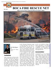
- Page 1:
City of Boca RatonStormwater Manage
- Page 5 and 6:
City of Boca Raton Stormwater Manag
- Page 7 and 8:
City of Boca Raton Stormwater Manag
- Page 9 and 10:
City of Boca Raton Stormwater Manag
- Page 12 and 13:
City of Boca Raton Stormwater Manag
- Page 14 and 15:
City of Boca Raton Stormwater Manag
- Page 16 and 17:
City of Boca Raton Stormwater Manag
- Page 18 and 19:
City of Boca Raton Stormwater Manag
- Page 20 and 21:
City of Boca Raton Stormwater Manag
- Page 22 and 23:
City of Boca Raton Stormwater Manag
- Page 24 and 25:
City of Boca Raton Stormwater Manag
- Page 26 and 27:
City of Boca Raton Stormwater Manag
- Page 28 and 29:
City of Boca Raton Stormwater Manag
- Page 30 and 31:
City of Boca Raton Stormwater Manag
- Page 32 and 33:
City of Boca Raton Stormwater Manag
- Page 34 and 35:
City of Boca Raton Stormwater Manag
- Page 36 and 37:
City of Boca Raton Stormwater Manag
- Page 38 and 39:
City of Boca Raton Stormwater Manag
- Page 40 and 41:
City of Boca Raton Stormwater Manag
- Page 42 and 43:
City of Boca Raton Stormwater Manag
- Page 44 and 45: City of Boca Raton Stormwater Manag
- Page 46 and 47: City of Boca Raton Stormwater Manag
- Page 48 and 49: City of Boca Raton Stormwater Manag
- Page 50 and 51: City of Boca Raton Stormwater Manag
- Page 52 and 53: City of Boca Raton Stormwater Manag
- Page 54 and 55: City of Boca Raton Stormwater Manag
- Page 56 and 57: City of Boca Raton Stormwater Manag
- Page 58 and 59: City of Boca Raton Stormwater Manag
- Page 60 and 61: City of Boca Raton Stormwater Manag
- Page 62 and 63: City of Boca Raton Stormwater Manag
- Page 64 and 65: City of Boca Raton Stormwater Manag
- Page 66 and 67: City of Boca Raton Stormwater Manag
- Page 68 and 69: City of Boca Raton Stormwater Manag
- Page 70 and 71: City of Boca Raton Stormwater Manag
- Page 72 and 73: City of Boca Raton Stormwater Manag
- Page 75: Appendix ATask 1 - Existing Conditi
- Page 79: Engineer’s Signature PageI hereby
- Page 82 and 83: City of Boca Raton Stormwater Manag
- Page 84 and 85: City of Boca Raton Stormwater Manag
- Page 86 and 87: City of Boca Raton Stormwater Manag
- Page 88 and 89: City of Boca Raton Stormwater Manag
- Page 90 and 91: City of Boca Raton Stormwater Manag
- Page 92 and 93: City of Boca Raton Stormwater Manag
- Page 96 and 97: City of Boca Raton Stormwater Manag
- Page 98 and 99: City of Boca Raton Stormwater Manag
- Page 100 and 101: City of Boca Raton Stormwater Manag
- Page 103: APPENDIX ASCOPE OF SERVICES
- Page 106 and 107: Impervious AreaWater Quality Volume
- Page 108 and 109: Task 1 Deliverables - The CONSULTAN
- Page 110 and 111: Task 2 Deliverable - The CONSULTANT
- Page 113: P.A. No.: A6016.01g:\boca\bocaswmp\
- Page 117: ICWWg:\boca\bocaswmp\drng network.m
- Page 121: P.A. No.: A6016.01g:\boca\bocaswmp\
- Page 127: CAMINO REALICWWJOG RDg:\boca\bocasw
- Page 131: P.A. No.: A6016.01g:\boca\bocaswmp\
- Page 135: g:\boca\bocaswmp\road_level.mxd.3Y/
- Page 139 and 140: Table 1SFWMD Permit Data(Selected E
- Page 141 and 142: ComplaintIDSite Address Subdivis Da
- Page 143: Table 3Major Outfall InformationMaj
- Page 146 and 147:
Table 4Potential High Risk Facility
- Page 148 and 149:
City of Boca RatonStormwater Manage
- Page 151:
City of Boca RatonStormwater Manage
- Page 155:
City of Boca Raton Regulatory Infor
- Page 158 and 159:
City of Boca Raton Regulatory Infor
- Page 160 and 161:
City of Boca Raton Regulatory Infor
- Page 162 and 163:
City of Boca Raton Regulatory Infor
- Page 164 and 165:
City of Boca Raton Regulatory Infor
- Page 166 and 167:
City of Boca Raton Regulatory Infor
- Page 168 and 169:
City of Boca Raton Regulatory Infor
- Page 170 and 171:
City of Boca Raton Regulatory Infor
- Page 172 and 173:
City of Boca Raton Regulatory Infor
- Page 174 and 175:
City of Boca Raton Regulatory Infor
- Page 176 and 177:
City of Boca Raton Regulatory Infor
- Page 178 and 179:
City of Boca Raton Regulatory Infor
- Page 180 and 181:
City of Boca Raton Regulatory Infor
- Page 182 and 183:
City of Boca Raton Regulatory Infor
- Page 184 and 185:
City of Boca Raton Regulatory Infor
- Page 187:
City of Boca RatonStormwater Manage