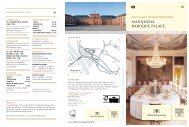
Schwetzingen - Schlösser-Magazin
Schwetzingen - Schlösser-Magazin
Schwetzingen - Schlösser-Magazin

Create successful ePaper yourself
Turn your PDF publications into a flip-book with our unique Google optimized e-Paper software.
oad, where the new crossing had been shaped<br />
into a circus. 38 Of the planned hunting park<br />
southwest of the palace gardens, an eight-lane<br />
“Jagdstern” (a star-shaped enclosure) housing<br />
fallow deer had been built; it was connected to<br />
the garden by an avenue (see Fig. 4). 39<br />
The Nineteenth and Twentieth Centuries<br />
In the course of the 19th century, the town of<br />
<strong>Schwetzingen</strong> expanded largely on the lines<br />
laid out in Bibiena’s Baroque building plan.<br />
Densely built-up areas developed along the<br />
existing roads to the north, south, and east.<br />
To the west of the garden, the areas of arable<br />
land grew to include what had formerly been<br />
woodland (see Fig. 9).<br />
Until well into the second half of the 19th<br />
century, <strong>Schwetzingen</strong> was connected to the<br />
neighbourhood by two major roads. One road<br />
led up from Mannheim and continued south;<br />
the other was the former electoral avenue<br />
connecting <strong>Schwetzingen</strong> to the “Bergstraße”.<br />
When the first direct railway from Mannheim<br />
to Karlsruhe via <strong>Schwetzingen</strong> was opened<br />
in 1870, the town received its first railway<br />
connection. The station building was erected<br />
on the eastern outskirts, along with the<br />
railway lines running at right angles to the<br />
former Heidelberger Straße, the Baroque<br />
east-west axis (see Fig. 8). The extension<br />
of the railway network continued with the<br />
construction of the Heidelberg-Speyer line. In<br />
the <strong>Schwetzingen</strong>, Eppelheim and Plankstadt<br />
areas, this was built in places to run exactly<br />
where the old avenue leading to Heidelberg<br />
had been, with the inevitable damages<br />
resulting. 40 The older road to Heidelberg,<br />
further to the north, became important<br />
again. During the 1920s, the tramways<br />
system was extended, with a line connecting<br />
<strong>Schwetzingen</strong> and Heidelberg via Carl-<br />
Theodor-Brücke and Nadlerstraße.<br />
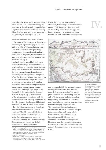
38 Cp. Martin 1933, p. 44. In the second half of the 19th century,<br />
Christian Mayer S. J. used the axes as coordinates when conducting<br />
the first exact survey of the Rhine valley (Fig. 5); the<br />
cartographical result was the “Basis novae Chartae Palatinae”<br />
(Fig. 7: Basis novae Chartae Palantinae. 1773.)<br />
39 Cp. Wertz 2002, p. 25.<br />
40 Cp. Joachim Stephan, “Infrastruktur und Zentralität. Die<br />
Amtsstadt <strong>Schwetzingen</strong> und das Straßenbahnprojekt<br />
<strong>Schwetzingen</strong>-Ketsch”, in: Badische Heimat, 1/2004, pp. 73-84.<br />
IV. Palace Gardens: Role and Significance<br />
Unlike the former electoral capital of<br />
Mannheim, <strong>Schwetzingen</strong> escaped destruction<br />
during WWII. Later extensions were built<br />
on the existing road network. In 1974, two<br />
large-scale projects were completed: a new<br />
hospital was built south of the palace gardens,<br />
and to the north, high-rise apartment blocks<br />
went up; both structures were intended<br />
to mark the respective ends of the town’s<br />
great transverse axis. The built-up areas not<br />
only of <strong>Schwetzingen</strong> itself, but also of the<br />
neighbouring communities of Oftersheim<br />
and Plankstadt, kept growing; today the three<br />
towns have largely merged into one.<br />
The importance of the railroad system<br />
declined with the rise of individual transport<br />
in the course of the 20th century. Both<br />
the railroad and tram lines connecting<br />
<strong>Schwetzingen</strong> and Heidelberg were<br />
abandoned. Today, two motorways and a<br />
high-speed train line run past the town area,<br />
connecting <strong>Schwetzingen</strong> to the long-distance<br />
network through a number of new connecting<br />
roads.<br />
IV.<br />
Fig. 7: Christian Mayer,<br />
‘Basis novae Chartae Palatinae’,<br />
engraving by C. Verelst, 1773<br />
(Karlsruhe, Generallandesarchiv).<br />
The palace formed the<br />
focal point of a Baroque system<br />
of axes, created by the electoral<br />
town and landscape planning<br />
– in keeping with Absolutist<br />
ideas, it was to dominate its<br />
surroundings, the radiant<br />
centre of the town.<br />
95