rück nach der Barra do Rio Negro. - Brasiliana USP
rück nach der Barra do Rio Negro. - Brasiliana USP
rück nach der Barra do Rio Negro. - Brasiliana USP
Sie wollen auch ein ePaper? Erhöhen Sie die Reichweite Ihrer Titel.
YUMPU macht aus Druck-PDFs automatisch weboptimierte ePaper, die Google liebt.
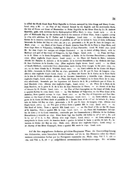
is added the North Coast from Point Espinilla to Colonia surveyed by John Cragg and Henry Foster.<br />
Lond. 1819. 2 Bl. — 25. Plan of the Channel formed by the English and the Archimedes Bank,<br />
the Isle of Flores and Coast of Montevideo to Point Espinilla in the Biver Plata by Lt. D. Andrew<br />
Oyarvide, publ. with Additions by the Hydrographical Office Madr. in I819. Lond. 1819. — 26. A<br />
plan of Mal<strong>do</strong>na<strong>do</strong> Bay on the northern shore at the entrance of Biver Plate, from a spanish survey<br />
in 1789 with additions by P. Parker and J. Engledue. Lond. 1821. — 27. Carta esferica de las<br />
Costas de la America meridional desde el parallelo de 36 0 30' de latitud S. hasta el Cabo de Homos;<br />
levantada de Orden del Bey en 1789, 90, 94 y 95, presentada a S. M. por D. Juan de Langara etc.<br />
Madr. 1798. — 28. Chart of the Coasts of South America from <strong>Rio</strong> de la Plata to Cape Hörn, and<br />
from Cape Hörn to Valparaiso, including the isles of Juan Fernandes. Lond. W. Faden 1821. (zwei<br />
Bl. Ist eine Copie <strong>der</strong> vorigen mit einigen Zusätzen.) — 29- A sketch of Ship Island, with its<br />
Harbour and part of the Coast of Patagonia, by Cpt. Folger. Lond. 1816. — 30. Piano del Puerto<br />
de S. Elena cn la Costa Patagonica; trabaja<strong>do</strong> a bor<strong>do</strong> de las Corvetas Descubierta y Atrevida.<br />
1794. (Eine englische Copie davon. Lond. 1819.) — 30. Piano del Puerto de Melo; trabaja<strong>do</strong><br />
abor<strong>do</strong> del Falucho S. Antonio y de la Lancba de la Corveta Descubierta a las Ordenes del Capt.<br />
• D. Juan Gutierrez de la Concha. 1795. (Eine englische Copie davon. Lond. 1820.) — 32. Chart<br />
of South Shetland, construeted from observalions made during three voyages in the years 1820, 21,<br />
22, 23 <strong>do</strong> these Islands by J. Weddell. Lond. 1825. — 33. Carta esferica de las Costas del Reyno<br />
de Chile, levantada de Orden del Rey en 1790, presentada a S. M. por D. Juan de Langara. 1799.<br />
(Davon eine englische Copie Lond. 1805.) — 34. Piano del Puerto de S. Carlos en la Parte Norte<br />
de la Isla de Chiloe; trabaja<strong>do</strong> abor<strong>do</strong> de las Corvetas Descubierta y Atrevida. 1700. (Davon eine<br />
englische Copie, Lond. 1820.) — 35. Piano del Puerto de Valdivia cn la Costa Oestc de la America<br />
meridional, levanta<strong>do</strong> por los Ingenieros del Eiercito de S. M. y rectifica<strong>do</strong> por el Piloto D.<br />
Jose Moraleda 1788. (Davon eine englische Copie, Lond. 1819.) — 36. Piano de la Rada de S.<br />
.Juan Bautista, en la parte N. E. de la Isla de Juan Fernandez de Tierra. — 37. Sketch of de Bay<br />
of Arauco by H. Foster. Lond. 1821. — 38. Plan of Port Conception on the Coast of Chili, from<br />
a spanish Survey in 1790. Lond. 1820. — 39. The Harbour of Valparaiso, on the West Coast of S.<br />
America, from spanish surveys in 1790. Lond. 1817. — 40. The Bay of Coquimbo and Port Herradura<br />
on the Coast of Chili, from a spanish Manuscr. Lond. 1317. — 41. Carta esferica de una<br />
parte de la Costa del Peru desde el parallelo de 7 Gra<strong>do</strong>s hasta el de 21° 45' de latitude S., levantada<br />
de Orden del Bey en 1790 , presentada a S. M. por D. Juan de Langara. 1798. (Davon eine<br />
Copie Lond. 1805.) — 42. The port of Pisco from a spanish MS. in 1795. Lond. 1817. — 43.<br />
The Boad of Arica, from a spanish MS. Lond. 1817. — 44. The Road of Ho on the W. Coast.<br />
of S. America, from a spanish MS. in 1793. Lond. 1817. — 45. Piano del Fondea<strong>do</strong>ro del Callao<br />
de Lima y de la Costa immediata, construida por los Commandantes y Oficiales de las Corbetas<br />
Descurbierta y Atrevida en 1790. Diese Karte legt das Castillo del Callao in 12 0 3' 38" s. Br. und<br />
in 79 25' 4" w. L. v. Par. (Davon eine engl. Copie, Lond. 1820.) — 46. Carta esferica que<br />
compriende la Costa oeeid. de America desde 7 gra<strong>do</strong>s de latitud S. hasta 9 gra<strong>do</strong>s de latit. N., levantada<br />
de Orden del Rey en 1791. Ma-dr. 1800. (Davon eine englische Copie, Lond. 1805.)' —<br />
47. Survey of the River Guayaquil, from a spanish MS. made in 1791. Lond. 1818.<br />
31<br />
Auf die hier angegebenen Seekarten gründete» Hauptmann WEISS die Gesammtbegränzung<br />
von Sudamerica, unter beson<strong>der</strong>er Rücksichtnahme auf die in den Memorias sobre las Obserraciones<br />
astronomicas hechas por los Navegantes espannoles etc. Madr. 1809. Vol. I. S. 136 —<br />
154. und Vol. 2. S, 76 — 91 aufgeführten astronomischen Ortsbestimmungen. Dii scliätzba-


