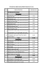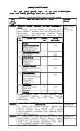
Tamil Nadu Urban Infrastructure Financial Services ... - Municipal
Tamil Nadu Urban Infrastructure Financial Services ... - Municipal
Tamil Nadu Urban Infrastructure Financial Services ... - Municipal

You also want an ePaper? Increase the reach of your titles
YUMPU automatically turns print PDFs into web optimized ePapers that Google loves.
3. Economic profile and Land use<br />
This section analyzes issues relating to Town planning, land-use and economic status of the town.<br />
3.1 Planning efforts in Krishnagiri<br />
3.1.1 Krishnagiri Local Planning Area<br />
The Town and Country Planning (T&CP) Act 1971 (<strong>Tamil</strong> <strong>Nadu</strong> Act, 35 of 1972) provides for the<br />
preparation and sanction of Master Plan. It also envisages the Local Planning Areas and Authorities<br />
for the preparation of Master Plan. Krishnagiri <strong>Municipal</strong> Area has been declared as Krishnagiri Local<br />
Planning Area under section 10 (4) of the T&CP Act in G.O.Ms.No.1249 RD & LA Dt 16.5.74.and<br />
the Local Planning Authorities have been constituted under section 11(1) of the Act in<br />
G.O.Ms.No.650 RD & LA Dt8.4.1975.<br />
Krishnagiri Local Planning Area comprises of the Krishnagiri <strong>Municipal</strong> Area notified under section<br />
10 of Town and Country Planning (T&CP) Act 1971 by Government of <strong>Tamil</strong> <strong>Nadu</strong>. Accordingly the<br />
Local Planning Authority (LPA) has been constituted under section 11 (1) of T&CP Act 1971 by the<br />
government.<br />
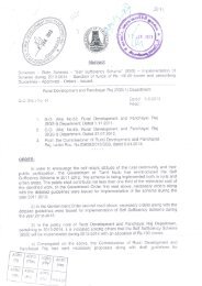
3.1.2 Krishnagiri Master Plan 2000 (2001-2011)<br />
The Krishnagiri Master plan was prepared and approved by the government in the year 1991 under<br />
section 28 of T&CP Act 1971 and the same is in operation now. The act provides review of master<br />
plan once in five years under clause (b) of sub section 2 of section 32 of the T&CP Act 1971;<br />
accordingly the government directed Krishnagiri Local Planning Authority (LPA) to revise the master<br />
plan. The approved 1991 master plan was based on the surveys conducted during 1987 and also<br />
based on the 1981 census, hence fresh surveys were undertaken and the reports were updated with<br />
1991 census by the LPA.<br />
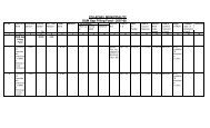
3.1.3 Land-use and development as per Master Plan 2000<br />
The present administrative area of Krishnagiri town extends over an area of 1150 hectares. However,<br />
in the master plan 2000, it is mentioned that the municipal area is 9.78 sq km and the land use pattern<br />
in the master plan has been given accordingly. The total developed area of the town is 347 hectares<br />
out of the town area of 9.78 sq km.<br />
3.1.4 Existing Land-use as per Master Plan 2000<br />
The land distribution pattern demonstrates that Krishnagiri predominantly serves as nodal centre for<br />
trading activities. Almost 75.50% of the developed land is under residential / administrative buildings,<br />
reiterating its role. There are various centres offering employment to sizable work force in the town.<br />
Industrial use occupies an area of 22 ha, which accounts for 6.34% of the developed area. The<br />
CCP cum BP - Krishnagiri <strong>Municipal</strong>ity 8