- Page 1 and 2: THE DAVIS STRAIT A preliminary stra
- Page 3 and 4: AU THE DAVIS STRAIT A preliminary s
- Page 5 and 6: Contents Preface 5 Summary and conc
- Page 7 and 8: Preface The Bureau of Minerals and
- Page 9 and 10: anks are normally ice free or have
- Page 11 and 12: ed in large numbers in the assessme
- Page 13 and 14: cetaceans (whales and harbour porpo
- Page 15 and 16: placement and transport corridors.
- Page 17 and 18: shrimp and Greenland halibut, for i
- Page 19 and 20: Mitigation The risk of accidents an
- Page 21 and 22: Miljøet Det pelagiske miljø De fy
- Page 23 and 24: Fangst og udnyttelse Menneskelig ud
- Page 25 and 26: Indenfor fiskeriet, er risikoen for
- Page 27 and 28: Kumulative effekter Der vil være e
- Page 29 and 30: dybde, kan muligvis ændre på konk
- Page 31 and 32: ingsæl, spættet sæl, finhval, pu
- Page 33 and 34: tassannga misilittagarineqalersut s
- Page 35 and 36: Timmisat imarmiut amerlasoorsuit, q
- Page 37 and 38: lu klimami pissutsinut atuutunut tu
- Page 39 and 40: toqunartoqarneri arrortikkuminarner
- Page 41 and 42: toqusarnermik taarserneqarluni, uum
- Page 43 and 44: minguttitamiit ajoquserneqarsinnaan
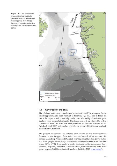
- Page 45: Kalaallit Nunaanni immikkut ulorian
- Page 49 and 50: VEC = Valued Ecosystem Components V
- Page 51 and 52: tings/well and in total 6,000 tons
- Page 53 and 54: 2.9 Other activities Ship transport
- Page 55 and 56: Figure 3.2.1. Major sea surface cur
- Page 57 and 58: 3.2.3 The coasts The coastal zone b
- Page 59 and 60: Jan Feb May Apr May Jul Aug Sep Oct
- Page 61 and 62: Figure 3.3.3. Average sea ice exten
- Page 63 and 64: Figure 3.3.4. Major iceberg sources
- Page 65 and 66: 4 Biological environment 4.1 Primar
- Page 67 and 68: Figure 4.1.1. Monthly progressions
- Page 69 and 70: Figure 4.2.1. Calanus spp. biomass
- Page 71 and 72: 69 Fish larvae are important compon
- Page 73 and 74: Figure 4.2.4. Red dots indicate san
- Page 75 and 76: focus should improve our understand
- Page 77 and 78: The coastal zone of the assessment
- Page 79 and 80: 183 macroalgal species (excl. the b
- Page 81 and 82: Table 4.3.1. Distribution of macroa
- Page 83 and 84: Chaetomorpha capillaris Chaetomorph
- Page 85 and 86: egistered in the area. A similar pa
- Page 87 and 88: The sea ice algal production in the
- Page 89 and 90: 1990) and then north (mid-2000s) in
- Page 91 and 92: September when they have reached a
- Page 93 and 94: Salmon, Salmo salar Biology and dis
- Page 95 and 96: tween 1 and 2.4 billion individuals
- Page 97 and 98:
It should be noted that the breedin
- Page 99 and 100:
66°N 64°N 62°N 60°W 60°W Arcti
- Page 101 and 102:
Knowledge on habitat use of the win
- Page 103 and 104:
Great shearwater, Puffinus gravis T
- Page 105 and 106:
Common eider, Somateria mollissima
- Page 107 and 108:
Figures 4.7.7. At-sea distribution
- Page 109 and 110:
Figure 4.7.9. Distribution and inte
- Page 111 and 112:
Figure 4.7.11. At-sea distribution
- Page 113 and 114:
The Iceland gull has a favourable c
- Page 115 and 116:
Figure 4.7.12. Distribution and int
- Page 117 and 118:
Murres spend very long time on the
- Page 119 and 120:
The puffins are migratory, but thei
- Page 121 and 122:
Figure 4.7.16. Density of whitetail
- Page 123 and 124:
sonal communication 1984) varied wi
- Page 125 and 126:
Numbers: The status of the walrus s
- Page 127 and 128:
tively impacted by disturbance from
- Page 129 and 130:
surround the eyes and line the oral
- Page 131 and 132:
Sensitivity: Non-whelping hooded se
- Page 133 and 134:
winter in reoccurring leads and pol
- Page 135 and 136:
Critical and important habitats: Th
- Page 137 and 138:
Figure 4.8.6. The main frequency ra
- Page 139 and 140:
tude breeding grounds and high lati
- Page 141 and 142:
Figure 4.8.7. Migration routes for
- Page 143 and 144:
long-finned squid (Loligo pealei) (
- Page 145 and 146:
Until recently the abundance of har
- Page 147 and 148:
Figure 4.8.9. Main summer and winte
- Page 149 and 150:
4.9.1 Pelagic hotspots The shelf ba
- Page 151 and 152:
5 Natural resource use 5.1 Commerci
- Page 153 and 154:
66°N 64°N 62°N 60°W Snow crab c
- Page 155 and 156:
Figure 5.1.4. Distribution and size
- Page 157 and 158:
Salmon, Salmo salar The fishery for
- Page 159 and 160:
Figure 5.2.2. Annual number of king
- Page 161 and 162:
2003/04-2007/08 the catch averaged
- Page 163 and 164:
66°N 64°N 62°N 66°N 64°N 62°N
- Page 165 and 166:
Figure 5.2.6. The West Greenland ca
- Page 167 and 168:
Figure 5.3.1. The number of cruise
- Page 169 and 170:
6.2 National nature protection legi
- Page 171 and 172:
formation see the IBA website (http
- Page 173 and 174:
glaucous gulls, great black-backed
- Page 175 and 176:
7.2 Conclusions on contaminant leve
- Page 177 and 178:
structures containing up to 10 ring
- Page 179 and 180:
The current warming trends are ofte
- Page 181 and 182:
species interactions. In the review
- Page 183 and 184:
8.5 Marine mammals and seabirds The
- Page 185 and 186:
9 Impact assessment David Boertmann
- Page 187 and 188:
10 Impacts of the potential routine
- Page 189 and 190:
Impact of seismic noise on zoo- and
- Page 191 and 192:
type or timing of vocalisations. In
- Page 193 and 194:
detailed studies on the effect of s
- Page 195 and 196:
Table 10.1.1. Overview of potential
- Page 197 and 198:
een eliminated on the grounds of en
- Page 199 and 200:
10.3 Development and production act
- Page 201 and 202:
hydrocarbon activities in Greenland
- Page 203 and 204:
parts of the shelf. Activities in t
- Page 205 and 206:
Seabird hunting is widespread and i
- Page 207 and 208:
There is a risk of reduced availabi
- Page 209 and 210:
General knowledge on the potential
- Page 211 and 212:
week period after the Exxon Valdez
- Page 213 and 214:
In general, species with distinct s
- Page 215 and 216:
A study of the density and distribu
- Page 217 and 218:
majority of the biomass. From a bio
- Page 219 and 220:
waters longer. The coastal fishery
- Page 221 and 222:
Seal pups are very sensitive to dir
- Page 223 and 224:
indicates that similar long-term im
- Page 225 and 226:
other parameters. It should be note
- Page 227 and 228:
Autumn (September-November) During
- Page 229 and 230:
to oil spills and produced water. I
- Page 231 and 232:
12.2.1 Ecotoxicological Monitoring
- Page 233 and 234:
Andersen JB, Böcher J, Guttmann B,
- Page 235 and 236:
Anon (2011b). Selvstyrets bekendtg
- Page 237 and 238:
Blackwell SB, Lawson JW, Williams M
- Page 239 and 240:
Born EW (2003). Reproduction in mal
- Page 241 and 242:
Buch E, Nielsen MH, Pedersen SA (20
- Page 243 and 244:
Clark RC, Finley JS (1977). Effects
- Page 245 and 246:
Dietz R, Heide-Jørgensen MP (1995)
- Page 247 and 248:
Falk K, Møller S (1997). Breeding
- Page 249 and 250:
Gjertz I, Kovacs KM, Lydersen C, Wi
- Page 251 and 252:
Hansen JLS, Hjorth M, Rasmussen MB,
- Page 253 and 254:
Heide-Jørgensen MP, Laidre KL (201
- Page 255 and 256:
Horsted SA (2000). A review of the
- Page 257 and 258:
Jonas RF (1974). Prospect for the e
- Page 259 and 260:
Ketten DR, Lien J, Todd S (1993). B
- Page 261 and 262:
Lick R, Piatkowski U (1998). Stomac
- Page 263 and 264:
Melle W, Serigstad B, Ellertsen B (
- Page 265 and 266:
Mosbech A, Danø R, Merkel FR, Sonn
- Page 267 and 268:
Nielsen OK, Lyck E, Mikkelsen MH, H
- Page 269 and 270:
Parry GD, Gason A (2006). The effec
- Page 271 and 272:
Popper AN, Fewtrell J, Smith ME, Mc
- Page 273 and 274:
Rivkin RB, Tian R, Anderson MR, Pay
- Page 275 and 276:
Schaaning MT, Trannum HC, Øxnevad
- Page 277 and 278:
Simpson AC, Howell BR, Warren PJ (1
- Page 279 and 280:
Taylor MK, Akeeagok S, Andriashek D
- Page 281 and 282:
Wegeberg S, Bangsholt J, Dolmer P,
- Page 283 and 284:
[Blank page]