

CockburnCoast - Western Australian Planning Commission
CockburnCoast - Western Australian Planning Commission
CockburnCoast - Western Australian Planning Commission

Create successful ePaper yourself
Turn your PDF publications into a flip-book with our unique Google optimized e-Paper software.
<strong>CockburnCoast</strong><br />
The construction of the power station, including the two groynes<br />
forming the intake area, caused erosion to the south that required<br />
the construction of a rock revetment. An additional groyne (groyne<br />
3) was constructed to the north to help reduce the rate of<br />
sedimentation in the intake area.<br />
Groyne 3 has caused beach accretion to the north which<br />
counteracted the downdrift erosion to the south of the Catherine<br />
Point groyne until 2001. Historically, seawalls and timber groynes<br />
had also been installed to mitigate shoreline erosion impacts on the<br />
recreation facilities, freight railway, switchyard and the ANI Bradken<br />
foundry site.<br />
Additional dredging, nourishment and mitigation structures have<br />
been conducted in the Cockburn coast district structure plan project<br />
area and the wider Owen Anchorage.<br />
6.2.3 Coastal processes<br />
The behaviour of the Cockburn coast shoreline is controlled by<br />
human modifications, in combination with seasonal and inter-annual<br />
variation in sediment transport rates and sediment supply. The<br />
sediment transport rates are mainly governed by the sediment<br />
supply, seasonal variation in wave conditions and wind-driven<br />
currents, and the rate of saturation and bypassing of the structures.<br />
The Cockburn coast is partially sheltered from ocean wave action by<br />
the reefs and islands between Garden and Rottnest islands, and the<br />
broad shallows of Success and Parmelia banks. These features act<br />
to modify the prevailing wave directions on a local scale, enhancing<br />
the significance of north-west winter storms compared with the more<br />
frequent south-west storms. During summer and early autumn, the<br />
prevailing wave conditions are south-south-westerly wind waves,<br />
generated by strong sea breezes blowing along the length of the<br />
coastal lagoon from Cockburn Sound to Owen Anchorage.<br />
Seasonal switching of the prevailing wave directions causes<br />
corresponding reversals in the direction of sediment transport and a<br />
rotation in the alignment of pocket beaches. The seasonal switching<br />
also influences the magnitude of the bypassing of Island Street<br />
groyne to the north, Catherine Point groyne to the south, the power<br />
station groyne 3 in both directions and the power station groyne 2 to<br />
the south. Additional seasonal sediment transport occurs due to<br />
aeolian (wind-driven) transport.<br />
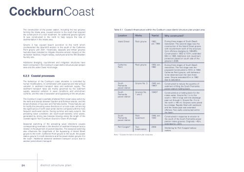
Table 6.1: Coastal infrastructure within the Cockburn coast district structure plan project area<br />
Location Works Year(s)<br />
Island Street Rock groyne 1962,<br />
ext. 1996<br />
Catherine Rock groyne 1959, ext.<br />
Point 1962<br />
South Groyne No. 3 1949, ext.<br />
Fremantle 1960?<br />
power station<br />
South Groynes No. 1946/7<br />
Fremantle 1 and 2<br />
power station<br />
South Rock 1948, ext.<br />
Fremantle revetment 1949<br />
power station<br />
Port Coogee* Two 2006<br />
breakwaters<br />
Note: * Outside the district structure plan study area<br />
Why constructed?<br />
During three stages of South Beach<br />
restoration. The second stage was the<br />
construction of the Island Street groyne<br />
with nourishment north of the structure<br />
from offshore dredging (in 1964/65).<br />
Constructed in 1962 to 107m, extended<br />
80m in 1996. Additional rock revetment<br />
protection placed on south side of the<br />
groyne in 2006.<br />
During three stages of South Beach<br />
restoration. The first stage was the<br />
proposed Constructed to 107m in 1959.<br />
Catherine Point groyne, with behaviour<br />
to be observed over the next three<br />
years. Groyne extended 61m in 1962<br />
due to saturation.<br />
Constructed to reduce the quantity of<br />
sediment infilling the South Fremantle<br />
power station holding basin.<br />
Constructed as a holding basin for the<br />
intake water. Groyne No.1 is to the<br />
south (~180 m long) with the discharge<br />
pipe cut through it. Groyne No. 2 is to<br />
the north (~165 m). Groynes were joined<br />
by a bridge. Rapidly filled with sediment<br />
and the intake pipe was extended<br />
offshore. Two walls constructed within<br />
the basin.<br />
Constructed in response to erosion to<br />
the south of the South Fremantle power<br />
ptation intake groynes. Originally ~45m,<br />
extended to ~22m.<br />
Sheltering for Port Coogee harbour<br />
waters.<br />
84 district structure plan


