

CockburnCoast - Western Australian Planning Commission
CockburnCoast - Western Australian Planning Commission
CockburnCoast - Western Australian Planning Commission

You also want an ePaper? Increase the reach of your titles
YUMPU automatically turns print PDFs into web optimized ePapers that Google loves.
ROAD<br />
FREEWAY<br />
GEOCENTRIC DATUM OF AUSTRALIA<br />
<strong>CockburnCoast</strong><br />
Chapter 5<br />
Regional context<br />
5.1 Cockburn coast<br />
challenges<br />
The Perth and Peel regions are facing significant social, economic,<br />
population, demographic, transport and land use challenges. The<br />
Directions 2031 strategy expresses a contemporary understanding<br />
of these challenges and identifies preferred approaches to how<br />
these challenges must be factored into the future planning for<br />
Cockburn coast and surrounding areas. The WAPC recognises the<br />
opportunity to capitalise on the Cockburn coast district structure<br />
plan and establish a new paradigm for urban regeneration projects<br />
that seek to deliver Directions 2031 objectives.<br />
This section outlines the regional context within which the Cockburn<br />
coast sits and must respond to, before later chapters present the<br />
planning and site context which have been critical factors in the<br />
development of the plan.<br />
5.2 The regional analysis<br />
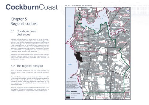
Figure 5.1 illustrates the structure plan area in the context of the<br />
Cockburn coast's area of influence and surrounding coastal<br />
suburbs.<br />
Figure 5.1: Cockburn coast area of influence<br />
Indian<br />
North<br />
Fremantle<br />
Ocean<br />
Town<br />
of<br />
Cottesloe<br />
Cottesloe<br />
Shire<br />
of<br />
Peppermint<br />
Grove<br />
City<br />
of<br />
Fremantle<br />
Town<br />
of<br />
Mosman Park<br />
Mosman Park<br />
Fremantle<br />
South<br />
Fremantle<br />
Swanbourne<br />
Town<br />
of<br />
Claremont<br />
Claremont<br />
East<br />
Fremantle<br />
Town<br />
of<br />
East Fremantle<br />
Bicton<br />
Palmyra<br />
City of Fremantle<br />
Hilton<br />
Beaconsfield<br />
COCKBURN<br />
STIRLING<br />
LEACH<br />
White Gum Valley<br />
Coogee<br />
Mount Claremont<br />
SOUTH<br />
CANNING<br />
Hamilton Hill<br />
Spearwood<br />
Shenton Park<br />
Karrakatta<br />
City<br />
of<br />
Nedlands<br />
Dalkeith<br />
O’Connor<br />
Swan<br />
Attadale<br />
Melville<br />
Samson<br />
Willagee<br />
Coolbellup<br />
ROE<br />
Crawley<br />
Alfred<br />
Cove<br />
Myaree<br />
Kardinya<br />
Yangebup<br />
River<br />
Applecross<br />
Ardross<br />
Booragoon<br />
Winthrop<br />
City of Melville<br />
North Lake<br />
Bibra Lake<br />
HIGHWAY<br />
HIGHWAY<br />
HIGHWAY<br />
Murdoch<br />
City of Cockburn<br />
South Lake<br />
Mount<br />
Pleasant<br />
Brentwood<br />
Bateman<br />
STREET<br />
KWINANA<br />
Bull Creek<br />
South Perth<br />
Como<br />
City of<br />
South Perth<br />
Manning<br />
Salter Point<br />
Rossmoyne<br />
Leeming<br />
Jandakot<br />
Victoria Park<br />
Carlisle<br />
Town of<br />
Kensington Victoria Park<br />
Karawara<br />
HIGHWAY<br />
ARMADALE<br />
Waterford<br />
Shelley<br />
East Victoria Park<br />
Bentley<br />
Riverton<br />
St James<br />
Wilson<br />
Parkwood<br />
Willetton<br />
City of Canning<br />
Canning Vale<br />
STOCK<br />
ROAD<br />
The wider Cockburn coast area of influence is defined by a 30<br />
minute travel time zone and includes the local government areas of<br />
Cockburn, Fremantle, East Fremantle and Melville. The areas<br />
provide the majority of the local employment opportunities for the<br />
new population and an established network of recreational and<br />
community facilities.<br />
The towns of Cottesloe and Mosman Park have been included in the<br />
demographic comparisons as they are likely to be indicative of a<br />
significant segment of the new population of the Cockburn coast.<br />
0<br />
1 2<br />
kilometres<br />
Produced by Project Mapping Section,<br />
Mapping and GeoSpatial Data Branch,<br />
Department for <strong>Planning</strong> and Infrastructure,<br />
on behalf of the <strong>Western</strong> <strong>Australian</strong> <strong>Planning</strong><br />
<strong>Commission</strong>, Perth, WA October 2007<br />
ntw-mapn\ \projects\pol\urb_inno\cockburn\<br />
v8_ccs_area_of_influenceA4.dgn<br />
Base information supplied by <strong>Western</strong> <strong>Australian</strong><br />
Land Information Authority, GL248-2007-2<br />
Legend<br />
N<br />
suburb boundary<br />
Munster<br />
Henderson<br />
Beeliar<br />
Wattleup<br />
Success<br />
Hammond<br />
Park<br />
Atwell<br />
Aubin<br />
Grove<br />
Banjup<br />
ROAD<br />
Forrestdale<br />
local government boundary<br />
area of influence<br />
study area<br />
Naval<br />
Base<br />
Mandogalup<br />
Hope Valley<br />
Town of Kwinana<br />
Wandi<br />
Oakford


