

CockburnCoast - Western Australian Planning Commission
CockburnCoast - Western Australian Planning Commission
CockburnCoast - Western Australian Planning Commission

Create successful ePaper yourself
Turn your PDF publications into a flip-book with our unique Google optimized e-Paper software.
GEOCENTRIC DATUM OF AUSTRALIA<br />
<strong>CockburnCoast</strong><br />
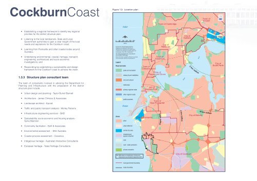
Figure 1.2: Location plan<br />
Town of<br />
Vincent<br />
Indian<br />
Town of Cambridge<br />
• Establishing a regional framework to identify key regional<br />
priorities for the district structure plan;<br />
• Listening to the local landowners, State and Local<br />
Government authorities to gain a clear insight of the local<br />
needs and aspirations for the Cockburn coast;<br />
• Learning from Fremantle and other coastal nodes around<br />
Australia;<br />
• Undertaking environmental, coastal, heritage, transport,<br />
engineering, architectural and socio-economic<br />
investigations; and<br />
• Responding by establishing a sustainability and design<br />
framework for the Cockburn coast to achieve the vision.<br />
1.3.3 Structure plan consultant team<br />
The team of consultants involved in advising the Department for<br />
<strong>Planning</strong> and Infrastructure with the preparation of the district<br />
structure plan include:<br />
0<br />
Legend<br />
N<br />
500 1000 1500 2000 2500<br />
metres<br />
Produced by Project Mapping Section,<br />
Mapping and GeoSpatial Data Branch,<br />
Department for <strong>Planning</strong> and Infrastructure,<br />
on behalf of the <strong>Western</strong> <strong>Australian</strong> <strong>Planning</strong><br />
<strong>Commission</strong>, Perth, WA October2007<br />
ntw-map9\ \projects\pol\urb_inno\cockburn\<br />
v8_ccs_MRS_PtoFA4.dgn<br />
Base information supplied by <strong>Western</strong> <strong>Australian</strong><br />
Land Information Authority, GL248-2007-2<br />
Reserved lands<br />
parks and recreation<br />
railway & port installation<br />
civic and cultural<br />
waterways<br />
primary regional roads<br />
Town of<br />
Claremont<br />
Town of<br />
Cottesloe<br />
Shire of<br />
Peppermint Grove<br />
Town of<br />
Mosman Park<br />
City of<br />
Nedlands<br />
City of<br />
Subiaco<br />
Swan<br />
5 km<br />
River<br />
radius<br />
City of Perth<br />
City of<br />
South Perth<br />
• Urban design and planning - Taylor Burrell Barnett<br />
other regional roads<br />
• Architecture - James Christou & Associates<br />
• Landscape architect - Epcad<br />
• Traffic and public transport analysis - Worley Parsons<br />
public purposes<br />
Ocean<br />
Town of<br />
East Fremantle<br />
• Infrastructure engineering services - GHD<br />
• Sustainability, socio-economic and housing analysis -<br />
Syme Marmion<br />
• Community facilitation - Estill & Associates<br />
Zones<br />
urban<br />
urban deferred<br />
City of Fremantle<br />
2<br />
km<br />
radius<br />
4 km<br />
radius<br />
City of Melville<br />
10 km radius<br />
• Environmental assessment - ENV Australia<br />
central city area<br />
• Coastal process assessment - Oceanica<br />
industrial and<br />
special industrial<br />
• Indigenous heritage - <strong>Australian</strong> Interactive Consultants<br />
rural<br />
• European heritage - Yates Heritage Consultants.<br />
rural - water protection<br />
private recreation<br />
NB: MRS detail is a simplification of Zones and<br />
Reservations as amended to September 2007<br />
City of Cockburn<br />
local government boundary<br />
study boundary


