

CockburnCoast - Western Australian Planning Commission
CockburnCoast - Western Australian Planning Commission
CockburnCoast - Western Australian Planning Commission

You also want an ePaper? Increase the reach of your titles
YUMPU automatically turns print PDFs into web optimized ePapers that Google loves.
<strong>CockburnCoast</strong><br />
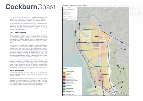
Figure 2.2: Pedestrian and cyclist pathways<br />
0 200<br />
400<br />
Metres<br />
Pr oduced by :<br />
Ma pp ing & Ge oS pa tial Da ta Br an ch<br />
Depa rtme nt of Pl an ning , WA<br />
On beha lf of :<br />
West er n Au st ralia n Pl an ning Co mm issi on<br />
Co py ri gh t (C ) Ju ly 2009<br />
The structure plan has provided for the broad linkages which<br />
provide strong east-west movement predominantly using public<br />
open spaces and north-south movement using the road network.<br />
nts- per\ma pgis \pro ject s\ perth\<br />
Cock bu rn Co ast _DSP\ mx d\DSP_9. 3m xd<br />
Base in fo rm ation su pp lie d by :<br />
West er n Au st ralia La nd In form ation Au thor ity<br />
GL 248- 2007- 2<br />
A key objective is to promote pedestrian and cycle links from the<br />
existing residential areas east of the development area to the<br />
beachfront, with green spine open spaces that promote the draw of<br />
community through the project area for everyday recreation and<br />
access to lifestyle amenity.<br />
2.6.5.1 Regional network<br />
From a regional perspective it is important to ensure that connection<br />
to Fremantle and to suburbs east of the structure plan is maintained<br />
and reinforced. Upgrade of the foreshore shared use path is likely<br />
be required within the structure plan area in the future to cater for the<br />
increased volume of pedestrians and cyclists likely to be using the<br />
path.<br />
Connections from Beeliar Regional Park to the east will also be<br />
important, as will connection to Spearwood Avenue. Upon<br />
reviewing the nature and form of the regional road network,<br />
specifically the Roe Highway (Stage 8) reservation, opportunities<br />
should be explored to reinstate an open space and pedestrian<br />
connection between Clontarf Hill and Beeliar Regional Park. The<br />
two sites are of particular significance to the local community and<br />
attention should be paid to formalising access should the primary<br />
regional road reservation be rationalised or realigned.<br />
Creation of transit lanes on Cockburn Road for the BRT system will<br />
present the opportunity to improve cyclist infrastructure along this<br />
important spine of the development. Cyclists may be catered for<br />
either through development of on-street lanes or within the transit<br />
lanes. Further detailed examination is required to investigate the<br />
most appropriate design solution for Cockburn Road in the future.<br />
2.6.5.2 Local network<br />
The diverse mixture of land uses within the structure plan area<br />
creates excellent potential for local trips to be made either by<br />
cycling or walking.<br />
Where necessary within the structure plan, shared use paths can be<br />
provided to facilitate cycling. Generally, cycling should be<br />
facilitated through the appropriate design of local streets. Shared<br />
use paths should only be provided where traffic volumes or other<br />
considerations make on-street riding unsafe or undesirable.<br />
Le gend<br />
La nd us e<br />
low density residential<br />
mixed use<br />
residential<br />
mixed business<br />
local activity node<br />
commercial/community<br />
South Fremantle Power Station<br />
freight rail reserve<br />
pedestrian linkage - bridge<br />
primary school<br />
sewer pump station<br />
public open space<br />
parks and recreation<br />
primary arterial road<br />
district distributor road<br />
local distributor road


