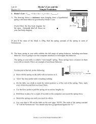
Radford University Undergraduate Catalog, 2011-2012
Radford University Undergraduate Catalog, 2011-2012
Radford University Undergraduate Catalog, 2011-2012

Create successful ePaper yourself
Turn your PDF publications into a flip-book with our unique Google optimized e-Paper software.
public lands systems. It covers history of the<br />
federal lands, legal and institutional framework,<br />
and planning and management concepts and<br />
processes such as environmental impact analysis.<br />
Current policy issues will be examined from<br />
several perspectives.<br />
GEOS 362. Water Resources. (4)<br />
Four hours lecture, laboratory, and field work.<br />
Prerequisites: GEOS 130, GEOL 100, or GEOL<br />
105, and GEOS 250, or permission of the instructor.<br />
An introduction to the science and policy aspects<br />
of water resources with emphasis on U.S.<br />
context.<br />
GEOS 380. Spatial Analysis Techniques. (4)<br />
Four hours lecture/laboratory.<br />
Prerequisite: GEOS 250 and STAT 200.<br />
The course, which will consist of both lecture<br />
and GIS lab applications, is devoted to description<br />
and application of methods for analyzing<br />
spatial distributions and to evaluation and assessment<br />
of geographic research problems in<br />
the context of GIS technology.<br />
GEOS 410. Advanced GIS. (T) (4)<br />
Four hours lecture and laboratory.<br />
Prerequisite: GEOS 125, GEOS 250, GEOS 315.<br />
Theory and practice of a geographic information<br />
system. Spatial data capture, manipulation<br />
of data sets, GIS Modeling, geodatabase considerations,<br />
manipulation of spatial data, and<br />
hardcopy map generation with a full-feature<br />
geographic information system.<br />
GEOS 412. Advanced Geoprocessing. (T) (3)<br />
Three hours lecture and laboratory.<br />
Prerequisite: GEOG 410.<br />
Theory and practice of advanced cartographic<br />
techniques. Research and cartographic design of<br />
complex cartographic projects and graphic design<br />
of cartograms will be practiced.”<br />
GEOS 425. Remote Sensing. (T) (4)<br />
Three hours lecture; three hours laboratory.<br />
Prerequisite: MATH 137, GEOS 130 (or GEOL<br />
105), and GEOS 125.<br />
Provides students the opportunity to (1) learn<br />
theory and practice of contemporary remote<br />
314<br />
sensing products (digital aerial photographs,<br />
digital orthophotos, airborne and satellite sensor<br />
platforms and their images), (2) learn and<br />
experiment with the technologies utilized in the<br />
analysis, image processing, and interpretation<br />
of these products, and (3) learn the use of the<br />
products in analog and digital format for other<br />
geographic technologies.<br />
GEOS 480. Seminar. (1-4)<br />
Three hours seminar.<br />
Prerequisite: Junior or senior standing.<br />
Intensive study of a special field of geography.<br />
Topics determined by instructors and students’<br />
interests. May be taken maximum of three times<br />
for no more than nine semester hours of credit.<br />
Depending upon the topic, this course may be<br />
used to meet requirements for the minor in Appalachian<br />
Studies.<br />
GEOS 488. Final Honors Project. (2-3)<br />
Prerequisite: Enrollment in the Honors Academy,<br />
completion of all other Honors Academy requirements,<br />
a minimum 3.5 GPA in all courses and in<br />
geography.<br />
Project and topic to be determined by the student,<br />
the faculty member with whom the student<br />
works, and the department. In order to receive<br />
honors credit, a student must earn a grade of<br />
“A” or “B” for the final project. Course may not<br />
be repeated.<br />
GEOS 490. Field Research Methods. (T) (3)<br />
Three hours lecture and field work.<br />
Prerequisite: Junior or Senior standing.<br />
Basic elements of geographic field research performed<br />
in <strong>Radford</strong> area. Course focuses on tools<br />
of field analysis. Students prepare single or group<br />
projects as indication of acquisition of logic of spatial<br />
analysis. This course may be used to meet requirements<br />
for the minor in Appalachian Studies.<br />
GEOS 492. Land Use. (3)<br />
Three hours lecture.<br />
Prerequisite: Junior or Senior standing.<br />
Study of concepts and perception of land use.<br />
Course stresses compatibility of geoecologic<br />
systems and land use.