- Page 3 and 4:
The Rainforests of CameroonDelivere
- Page 6 and 7:
© 2009 The International Bank for
- Page 8 and 9:
vi ContentsChapter 3 Objectives and
- Page 10 and 11:
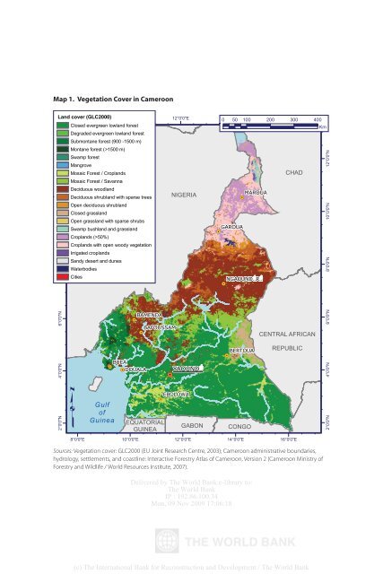
viii ContentsFigures3.1. Cameroon
- Page 12 and 13:
x Forewordof illegal activity. Oppo
- Page 14 and 15:
xii Preface and AcknowledgmentsIt i
- Page 16 and 17:
Delivered by The World Bank e-libra
- Page 18 and 19:
xvi AbbreviationsCOMIFAC Conference
- Page 20 and 21:
xviii AbbreviationsUS$VCWRIWWFU.S.
- Page 22 and 23:
2 The Rainforests of Cameroonintere
- Page 24 and 25:
4 The Rainforests of CameroonForest
- Page 26 and 27:
6 The Rainforests of Cameroonnity f
- Page 28 and 29:
8 The Rainforests of Cameroonimport
- Page 30 and 31:
10 The Rainforests of Cameroonas we
- Page 32 and 33:
Delivered by The World Bank e-libra
- Page 34 and 35:
14 The Rainforests of Cameroonsecto
- Page 36 and 37:
16 The Rainforests of CameroonAltho
- Page 38 and 39:
18 The Rainforests of CameroonCamer
- Page 40 and 41:
20 The Rainforests of CameroonAs th
- Page 42 and 43:
22 The Rainforests of CameroonThe c
- Page 44 and 45:
24 The Rainforests of CameroonIniti
- Page 46 and 47:
26 The Rainforests of CameroonLaw,
- Page 48 and 49:
28 The Rainforests of CameroonTable
- Page 50 and 51:
30 The Rainforests of CameroonFigur
- Page 52 and 53:
32 The Rainforests of CameroonFigur
- Page 54 and 55:
34 The Rainforests of CameroonEffor
- Page 56 and 57:
36 The Rainforests of CameroonBox 3
- Page 58 and 59:
38 The Rainforests of CameroonLocal
- Page 60 and 61:
40 The Rainforests of Cameroonrepre
- Page 62 and 63:
42 The Rainforests of Cameroonto el
- Page 64 and 65:
44 The Rainforests of CameroonManag
- Page 66 and 67:
46 The Rainforests of CameroonBox 3
- Page 68 and 69:
48 The Rainforests of CameroonBox 3
- Page 70 and 71:
50 The Rainforests of CameroonRefor
- Page 72 and 73:
52 The Rainforests of CameroonFigur
- Page 74 and 75:
54 The Rainforests of Cameroonto en
- Page 76 and 77:
56 The Rainforests of CameroonFESP
- Page 78 and 79:
58 The Rainforests of Camerooninsti
- Page 80 and 81:
60 The Rainforests of CameroonBox 3
- Page 82 and 83:
Delivered by The World Bank e-libra
- Page 84 and 85:
Delivered by The World Bank e-libra
- Page 86 and 87:
66 The Rainforests of Cameroonbeen
- Page 88 and 89:
68 The Rainforests of Cameroon4 mil
- Page 90 and 91:
70 The Rainforests of Cameroonoverc
- Page 92 and 93:
Delivered by The World Bank e-libra
- Page 94 and 95:
74 The Rainforests of Cameroonand c
- Page 96 and 97:
76 The Rainforests of Cameroonpende
- Page 98 and 99:
78 The Rainforests of CameroonCerut
- Page 100 and 101:
80 The Rainforests of Cameroonavera
- Page 102 and 103:
82 The Rainforests of CameroonThe N
- Page 104 and 105:
84 The Rainforests of CameroonFigur
- Page 106 and 107:
86 The Rainforests of CameroonAreas
- Page 108 and 109:
88 The Rainforests of CameroonFigur
- Page 110 and 111:
90 The Rainforests of CameroonFigur
- Page 112 and 113:
92 The Rainforests of CameroonFigur
- Page 114 and 115:
94 The Rainforests of CameroonBox 5
- Page 116 and 117:
96 The Rainforests of CameroonFigur
- Page 118 and 119:
98 The Rainforests of CameroonEquat
- Page 120 and 121:
100 The Rainforests of CameroonBox
- Page 122 and 123:
102 The Rainforests of CameroonTabl
- Page 124 and 125:
104 The Rainforests of Cameroonhas
- Page 126 and 127:
106 The Rainforests of Cameroonfore
- Page 128 and 129:
108 The Rainforests of CameroonThe
- Page 130 and 131:
110 The Rainforests of Cameroon10.
- Page 132 and 133:
Delivered by The World Bank e-libra
- Page 134 and 135:
Delivered by The World Bank e-libra
- Page 136 and 137:
116 The Rainforests of CameroonA pa
- Page 138 and 139:
118 The Rainforests of Cameroonerod
- Page 140 and 141:
120 The Rainforests of CameroonBox
- Page 142 and 143:
122 The Rainforests of CameroonAttr
- Page 144 and 145:
124 The Rainforests of CameroonTabl
- Page 146 and 147:
126 The Rainforests of CameroonFina
- Page 148 and 149:
128 The Rainforests of Cameroonin t
- Page 150 and 151:
Delivered by The World Bank e-libra
- Page 152 and 153:
132 Appendix 1resulted in paper ref
- Page 154 and 155:
134 Appendix 1estry laws and regula
- Page 156 and 157:
136 Appendix 2FMU numberFMUs alloca
- Page 158 and 159:
138 Appendix 2FMU number10.020 1038
- Page 160 and 161:
140 Appendix 2FMU number09.020 1069
- Page 162 and 163:
Delivered by The World Bank e-libra
- Page 164 and 165:
144 Appendix 3Type Name (type) Area
- Page 166 and 167: 146 Appendix 4Small-scale domestic
- Page 168 and 169: 148 Appendix 5The September 1997 ag
- Page 170 and 171: Delivered by The World Bank e-libra
- Page 172 and 173: 152 Appendix 6Code in 1994 and an E
- Page 174 and 175: 154 Appendix 6• The Vienna Conven
- Page 176 and 177: 156 Appendix 6Forestry taxation ref
- Page 178 and 179: 158 Appendix 6to CFAF 10 billion of
- Page 180 and 181: 160 Appendix 6Sangha National Park)
- Page 182 and 183: 162 Appendix 62. Better environment
- Page 184 and 185: Delivered by The World Bank e-libra
- Page 186 and 187: 166 Appendix 71998-99 2002-03 Evolu
- Page 188 and 189: 168 Appendix 71998-99 2002-03 Evolu
- Page 190 and 191: 170 Appendix 8Type of Processing ca
- Page 192 and 193: 172 Appendix 8Type of Processing ca
- Page 194 and 195: Delivered by The World Bank e-libra
- Page 196 and 197: 176 Appendix 9Situation in 1992Area
- Page 198 and 199: 178 Appendix 9Situation in 2004Fisc
- Page 200 and 201: Delivered by The World Bank e-libra
- Page 202 and 203: 182 Appendix 10forest service (or t
- Page 204 and 205: 184 ReferencesCarret, Giraud, and L
- Page 206 and 207: 186 Referencessented at the Rights
- Page 208 and 209: Delivered by The World Bank e-libra
- Page 210 and 211: 190 The Rainforests of CameroonCons
- Page 212 and 213: 192 The Rainforests of CameroonIPDP
- Page 214 and 215: 194 The Rainforests of Cameroonvolu
- Page 218 and 219: Map 2. Forest Use in Cameroon, 1992
- Page 220 and 221: Map 3. Status of Logging Titles in
- Page 222 and 223: Map 5. Status of Protected Areas in
- Page 224 and 225: Map 6. Conservation of the Ngoila-M