

ABSTRACTS / RESUMES - Comitato Glaciologico Italiano
ABSTRACTS / RESUMES - Comitato Glaciologico Italiano
ABSTRACTS / RESUMES - Comitato Glaciologico Italiano

Create successful ePaper yourself
Turn your PDF publications into a flip-book with our unique Google optimized e-Paper software.
lief formed by glaciers was transformed by numerous geomorphological<br />
processes: fluvioglacial, limnoglacial, solifluctional,<br />
erosion, eolian, thermokarst, littoral, limnic, fluvial,<br />
suffusion, karst, organogenic and anthropogenic. The<br />
action of these processes in different age formations of<br />
Lithuanian glacial relief varied. The duration and intensity<br />
of processes predetermined the degree of transformations.<br />
Most intensive postgenetic changes took place in the<br />
Lithuanian uplands. The largest area of postgenetic change<br />
is taken by erosion, thermokarst, organogenic, fluvioglacial<br />
and fluvial formations. The link was determined between<br />
the age of relief and postgenetic complexes and their intensity<br />
in the morainic massifs and moraine chains.<br />
Age<br />
Postgenetic changes of glacial relief of Lithuania (area, 0/0)<br />
Processes<br />
fluvioglacial fluvial thermokarst erosion organogenic<br />
Morainic massifs<br />
Saale glacier 5,1 0,9 4,11 9,7 6,7<br />
Vistula glacier<br />
Brandenburg stage 2,2 21,4 1,3<br />
Frankfurt stage 1,9 1,2 10,4 11,0 9,8<br />
Pomeranian stage<br />
East Lithuania phase 3,3 12,3 10,0 8,3<br />
South Lithuania phase 0,3 12,6 11,5 6,8<br />
Middle Lithuaniaphase 0,5 7,4 15,4 4,7<br />
Morainic chains<br />
Saale glacier 5,0 1,0 1,4 24,2 0,4<br />
Vistula glacier<br />
Brandenburg stage 4,0 0,5 8,2 13,1 14,8<br />
Frankfurt stage 1,5 12,7 12,4 12,5<br />
Pomeranian stage<br />
East Lithuanian phase 1,1 3,9 11,3 10,4 11,3<br />
South Lithuanian phase 14,6 9,8 10,3<br />
Middle Lithuanian phase 2,2 19,6 9,8 11,0<br />
D. CHANDRASEKHARAM & H.C. SHETH<br />
Significance of flow stratigraphy in deciphering erosional<br />
history of flood basalt provinces<br />
Department of Earth Sciences, Indian Institute of Technology,<br />
Bombay 76, India<br />
In huge continental flood basalt provinces such as the Deccan,<br />
India, multiple eruptive vents are generally the rule,<br />
each having its own sphere of influence. Often it is difficult<br />
to estimate the rate and volume of erosion from topographic<br />
expression only. It must be decided before estimating<br />
erosion rates that the lavas did once extend over the<br />
presently observed valleys. For example the gap between<br />
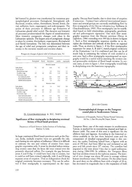
areas A and B (fig. 1) could have been due to erosion, but<br />
it could as well have existed originally, with A and B being<br />
separate areas of eruption. Thus an independent check for<br />
original continuity becomes necessary. This can be achieved<br />
if flow stratigraphy is superimposed on the topo-<br />
110<br />
graphy. Deccan flood basalts, due to their time of eruption<br />
(Cretaceous - Tertiary) have achieved international importance<br />
and several groups are currently establishing flow by<br />
flow stratigraphy of the Deccan volcanics. (e.g, Subbarao &<br />
Chandrasekharam, 1995). Flow stratigraphy can be established<br />
based on field relationships, petrography, geochemical<br />
and paleomagnetic signatures. One such flow stratigraphic<br />
sequence from the Deccan province (Devey &<br />
Lightfoot, 1986) extending over 300 km is shown in figure<br />
1. Such a flow stratigraphic sequence enables us to decipher<br />
the thickness and attitude of the flows on regional<br />
scale. Thus, as shown in figure 1, if the flow stratigraphic<br />
sequences for areas A, Band C match,original continuity<br />
of the Formations 1 to 4 is confirmed and this can be of<br />
much help in estimating the volume of rock eroded in a<br />
unit area. Such a flow stratigraphy superimposed on topography<br />
would be a useful tool in assessing the erosion caused<br />
geomorphic evolution of flood basalt terrains. In certain<br />
cases, as seen in figure 1, flow stratigraphy would help<br />
in deciphering even the basement topography.<br />
t!ffio<br />
1000<br />
500<br />
o<br />
FIG. 1<br />
JUI-CHIN CHANG<br />
Geomorphological changes on the Tsengwen<br />
coastal plain in Southwestern Taiwan<br />
Department of Geography, National Taiwan Normal University,<br />
162 Sec. 1, East Ho-ping Rd.,Taipei, Taiwan<br />
Tsengwen River, one of the main streams in southwestern<br />
Taiwan, is marked for its meandering channel and high sediment<br />
yield. The coast of this area is significant for the<br />
offshore bars and lagoons. According to the historical archives<br />
available in the last three hundred years and the<br />
comparision of detailed topographical maps in this century,<br />
the «paleo Taichiang Inland Sea», a lagoon with an<br />
area of 350 km', had been filled up and reclaimed as salt<br />
pans and fish ponds since 19 th<br />
century. The coastline had<br />
migrated to the west about 5 km due to rapid sedimentation<br />
during 1904-1990. In addition, the Tsengwen River<br />
had four avulsion events in the typhoon seasons. The interval<br />
of river change was about 50 years in average without<br />
human interference since 19th century. On the other hand,<br />
the sand dune on the offshore bars with a height of 10m,<br />
has decreased its magnitude due to the expansion of built


