

ABSTRACTS / RESUMES - Comitato Glaciologico Italiano
ABSTRACTS / RESUMES - Comitato Glaciologico Italiano
ABSTRACTS / RESUMES - Comitato Glaciologico Italiano

You also want an ePaper? Increase the reach of your titles
YUMPU automatically turns print PDFs into web optimized ePapers that Google loves.
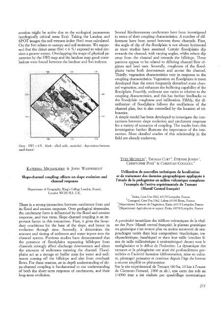
erosion might be active due to the ecological parameters<br />
(ecologically critical areas Eca). Taking the Landsat and<br />
SPOT images the soil wetness index (Swi) were calculated.<br />
On the Swi relates to canopy and soil moisture. We supposed<br />
that the driest areas (Swi < 6 %) exposed to wind erosion<br />
a greater extent. Overlapping the maps of physical parametes<br />
by the SWI map and the landuse map good correlations<br />
were found between the landuse and Swi indexes.<br />
Grey - SWI < 6 % , black - alkali soils , encircled - depressions between<br />
sand dunes?<br />
KATERINA MICHAELIDES & JOHN WAINWRIGHT<br />
Slope-channel coupling: effects on slope evolution and<br />
channel response<br />
Department of Geography, King's College London, Strand,<br />
London WC2R2LS, U.K.<br />
There is a strong interaction between catchment form and<br />
its flood and erosion response. Over geological timescales,<br />
the catchment form is influenced by the flood and erosion<br />
response, and vice versa. Slope-channel coupling is an important<br />
factor in this interaction. First, it gives the boundary<br />
conditions for the base of the slope, and hence its<br />
evolution through time. Secondly, it determines the<br />
amount and timing of sediment and water inputs into the<br />
channel system. Previous studies have demonstrated that<br />
the presence of floodplains separating hillslopes from<br />
channels strongly affect discharge downstream and alters<br />
the amounts of sediments entering the channel. Floodplains<br />
act as a storage or buffer zone for water and sediments<br />
coming off the hillslope and also from overbank<br />
flows. For these reasons, an in-depth understanding of slope-channel<br />
coupling is fundamental to our understanding<br />
of both the short-term response of catchments, and their<br />
long-term evolution.<br />
Several Mediterranean catchments have been investigated<br />
in terms of their coupling characteristics. A number of differences<br />
have been noted between these channels. First,<br />
the angle of dip of the floodplain is not always horizontal<br />
as most studies have assumed. Certain floodplains dip<br />
towards the channel, with varying angles, whilst others dip<br />
away from the channel and towards the hillslope. These<br />
patterns appear to be related to differing channel flow regimes<br />
and land uses. Secondly, roughness of the floodplains<br />
varies both downstream and across the channel.<br />
Thirdly, vegetation characteristics vary in response to the<br />
coupling characteristics. Vegetation on floodplains is more<br />
developed than the more frequently disturbed main channel<br />
vegetation, and enhances the buffering capability of the<br />
floodplain. Fourthly, sediment size varies in relation to the<br />
coupling characteristics, and this has further feedbacks to<br />
the floodplain roughness and infiltration. Fifthly, the distribution<br />
of floodplains follows the oscillations of the<br />
channel plan, but is also controlled by the location of tributaries.<br />
A simple model has been developed to investigate the interactions<br />
between slope evolution and catchment response<br />
for a variety of scenarios of coupling. The results from this<br />
investigation further illustrate the importance of the interaction.<br />
More detailed studies of this relationship in the<br />
field are already underway.<br />
YVES MICHELINI, THOMAS CURT 2 , ETIENNE JOSIEN1,<br />
CHRISTOPHE POIX 3 & CHRISTIAN COUGOUL 4<br />
Utilisation de nouvelles techniques de localisation<br />
et de traitement des donnees geographiques appliquee a<br />
l'etude de la pedogenese en milieu volcanique complexe:<br />
I'exemple de l'estive experimentale de Ternant<br />
(Massif Central francais)<br />
1 Enita, Cnrs Ura 1562,63370 Lempdes, France<br />
2 Cemagref, Cnrs Ura 1562, Laluas 63100 Riom, France<br />
3 Departement Sciences de l'ingenieur, Enita, 63370 Lempdes, France<br />
4 Departement Agricultures et espace, Enita, 63370 Lempdes, France<br />
A proximite immediate des edifices volcaniques de la chaine<br />
des Puys (Massif central francais), Ie plateau granitique<br />
ou gneissique s'est trouve plus ou moins recouvert de saupoudrages<br />
varies dans leur composition (trachytique, trachyandesitique,<br />
basaltique) et dans leur taille (cendres fines<br />
de taille millimetrique a centimetrique) durant tout Ie<br />
tardiglaciaire et Ie debut de l'holocene. La dynamique des<br />
versants et la pedogenese ont ainsi ete profondement perturbees<br />
et lactivite humaine (deforestation, mise en culture,<br />
parurage) puissante et continue depuis 1'age du bronze<br />
a encore amplifie ce phenomene,<br />
Sur Ie site experimental de Ternant (60 ha, 10 km al'ouest<br />
de Clermont-Ferrand, 1000 m alt.), une carte des sols au<br />
1/4500 erne a ete realisee par quadrillage systematique<br />
273


