

ABSTRACTS / RESUMES - Comitato Glaciologico Italiano
ABSTRACTS / RESUMES - Comitato Glaciologico Italiano
ABSTRACTS / RESUMES - Comitato Glaciologico Italiano

Create successful ePaper yourself
Turn your PDF publications into a flip-book with our unique Google optimized e-Paper software.
to the fluvial dinamics. This process is little represented in<br />
the island where the fluvial processes are rare and highly<br />
conditioned by the prevaling erosion.<br />
The considerable morphological differences of the area also<br />
allowed the localization of three distinct morphogenetic<br />
bands. The first, localized in the western sector, is influenced<br />
more by the structures. The second one, in the centre,<br />
preserves forms and fluvial deposits that define also the ancient<br />
surfaces of the plain. The third band, localized in the<br />
eastern sector, is almost exclusively represented by eolic<br />
processes.<br />
.The most recent and historically documented data are also<br />
reported, as well as the data about the climate and the recent<br />
variations of the River, so to add elements for the<br />
analysis of the relationship between climate and runoff<br />
regime.<br />
SERGIO GINESU & STEFANIA SIAS<br />
Morphocronological correlations between paleosurfaces<br />
and plio-quaternary volcanic events<br />
in the Northen Sardinia (Italy)<br />
Istituto di Scienze Geologico Mineralogiche,<br />
Universita di Sassari, c.so Angioy 10,07100 Sassari, Italy<br />
The presence of flat isolated surfaces long the valley slopes<br />
have been interpreted as erosional terracces, generally placed<br />
in calcareous rocks. Thesesurfaces present a restricted<br />
area, a width till 0.5 to 1 km', Moreovever, it was been possible<br />
to identified some areas included from 20 to 30 km 2<br />
as relicted surfaces. These are characterized by a weak relief<br />
energy and isolated in the landscape. A third surface is<br />
present at altitude between 650-700 m in all the territory.<br />
During the Plio - Pleistocene the island was interested by<br />
a periodical volcanic activity from 5 to 0.14 m.y.B.P.,<br />
many morphologies and deposits have been fossilized by<br />
the basaltic lava flows. The pliocenic volcanic activities have<br />
fossilized flat surfaces and small plains mostly at an altitude<br />
over 600 m. During the Middle Pleistocene the basaltic<br />
lava flows have preserved the fluvial network at 400 <br />
300 m altitude. The recentest volcanic events (Upper Pleistocene)<br />
have procteted some lacustrine deposits and some<br />
(2) buried soils formed by the volcanic dam in a subordinate<br />
creek.<br />
The correlation between all the different surfaces and the<br />
dating of each volcanic episodes has permitted to have the<br />
age of these landforms and dating the evolution processes<br />
that have formed the differnt landscape during the last 2<br />
million of years B.P.<br />
It was possible to identifie the climatic changes thanks to<br />
the presence of the deposits under the lava flows, the buried<br />
soils and the periglacial sediments.<br />
GABRIELE GIORGI<br />
Morphological evolution of the Bolognese plain (Italy)<br />
Dipartimento di Scienze della Terra e Geologico-ambientali,<br />
Universita di Bologna, via Zamboni, 67,40127 Bologna, Italy<br />
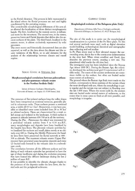
The aim of this study is to point out the morphological<br />
transformations in a portion of the Po River plain. To this<br />
end several methods were used, such as digital elevation<br />
model-building, archaeological, historical and cartographic<br />
data collecting and soil studies.<br />
In Po Plain rivers tend to flow elevated respect the surrounding<br />
areas, this is due to the continuous sedimentation<br />
in the river bed. When rivers overflow and flood, they<br />
abandon the previous course, creating a new one. The<br />
abandoned relief marks the old river bed.<br />
The invesigated area has been inhabited since the Bronza<br />
Age (about 1000 Be). During the Roman Age, the colonists<br />
developed the architectural grid (Centuriazione) still visible<br />
today. The traces of the ancient settlements are sometimes<br />
visible on the surface, but often are buried under<br />
many meters of sediments.<br />
The ground where the Roman Age finds were made on the<br />
surface, corresponds to those portions of the terrain where<br />
the most developed soils are, where the morphology is quite<br />
regular and the terrain was not subject to flooding over<br />
the last 3.000 years. Where the recent soils lie, the ancient<br />
sites are buried under several meters of sediments, to the<br />
extent that in some cases no finds at all were possible, and<br />
morphology is irregular.<br />
179


