

ABSTRACTS / RESUMES - Comitato Glaciologico Italiano
ABSTRACTS / RESUMES - Comitato Glaciologico Italiano
ABSTRACTS / RESUMES - Comitato Glaciologico Italiano

Create successful ePaper yourself
Turn your PDF publications into a flip-book with our unique Google optimized e-Paper software.
Observation of debris flows and sediment discharge were<br />
executed at three volcanoes: Mount Unzen, Mount Yakedake<br />
in Japan and Mount Merapi in Indonesia where the<br />
lava composition of volcano is similar and the main process<br />
of sediment discharge is the occurrence of boulderly type<br />
debris flow, in order to clarify the effectiveness of eruption<br />
to sediment discharge from volcanic drainage slope. We<br />
found that the rate of sediment discharge and the frequency<br />
of debris flow were different from each other, being<br />
affected by the time after eruption. Geomorphological factors<br />
and hydrological factors are summarized in Table 1.<br />
Comparing the specific amount of sediment transport, a<br />
general relationship is expected in which specific amount<br />
of sediment transport would decrease exponentially with<br />
the time after the last eruption of the volcano. Consideration<br />
of the result in Table and erosion rates in other studies<br />
(Swanson & alii, 1983; Chinen, 1986; Collins et al.,<br />
1986;·Shimokawa & alii, 1987) gives a general expectation,<br />
where the erosion rate of volcanic slope, initially very high<br />
immediately after the eruption, decreases from the magnitude<br />
10 1 - IO'rnm/yr, to l O'mm/yr in less than several years,<br />
and finally approaches IO'rnm/yr in less than a few decades.<br />
This fact recommends us to make response against potential<br />
debris-flow hazard as fast as possible just with the<br />
beginning of a volcanic eruption.<br />
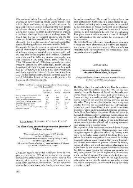
TABLE 1 - Condition of sediment discharge at three volcanic torrents<br />
from 1991 through 1994<br />
Drainage area for the observation site (km')<br />
Mean of annual precipitation (mm)<br />
Year of the last activity of effective eruption<br />
Time after the last effective eruption (years)<br />
Permeability of the slope (em/sec)<br />
Frequency of debris flow (Zyear)<br />
Total volume of sediment discharge 004ml/year)<br />
Erosion rate (rnm/year)<br />
Mt. Yakedake Mt. Merapi Mt. Unzen<br />
Kamikamihori G. Bebeng R Mizunashi R.<br />
0.83<br />
2,600<br />
1962<br />
32<br />
10-210-> 0.7<br />
0.5<br />
6<br />
5<br />
4,500<br />
1984<br />
10<br />
10-210-1 5<br />
20<br />
40<br />
LAFOS SZABO 1, T. SUMNYI K. 2 & ADAM KERTESZ 3<br />
12<br />
3,100<br />
1990-1995<br />
o 10-'10- 5<br />
23<br />
210<br />
175<br />
The effect of crop pattern change on erosion processes of<br />
hillslopes in Hungary<br />
1 University of Agricultural Sciences, H-2103 Godol1o,<br />
p.o. box 303. Hungary<br />
2 University of Horticulture and Food Industry, Villanyitit 29-43,<br />
H-1114 Budapest, Hungary<br />
3 Geographical Research Institute of Hungarian Academy of Sciences,<br />
p.o. box 64, H-1388 Budapest, Hungary<br />
2.3 million hectares are eroded to different extent in Hungary<br />
representing ca. 25 % of the surface of the country.<br />
Mountainous areas underwent a more serious erosion. The<br />
erosion risk is, however, greater in the hilly countries because<br />
of the agricultural activity there. The hills are mostly<br />
covered by brown forest soils developed on loess, loess-<br />
368<br />
like sediments and sand. The area of the original forest has<br />
been continuously diminishing as a consequence of agricultural<br />
activity leading to increasing erosion accompanied<br />
by the degradation of humus manifested in the thickness<br />
of the humus layer, in the quality of humus and in humus<br />
content. As it is well known the best way of combatting<br />
these phenomena is reforestration as a natural biological<br />
tool. Reforestration will also reduce the accumulation of<br />
toxic materials.<br />
The Godollo-Monor hilly country was chosen as a test area<br />
to study the above phenomena and to show the possibilities<br />
of concervation and improvement. Our research was<br />
supported by the «Foundation for soil concervation». This<br />
support is acknowledged here.<br />
ZOLTAN SZALAI<br />
Human impacts on a floodplain ecosystem:<br />
the case of Haros Island, Budapest<br />
Geographical Research Institute, Hungarian Academy of Sciences<br />
p.o. box 64,11-1338 Budapest, Hungary<br />
The Haros Island is a peninsula in the Danube section at<br />
Budapest, near Budateteny, Since the 1950's it has been<br />
closed to the public because of the military barracks established<br />
there. Thus, in the recent past direct human influence<br />
was kept at a moderate level but the impacts of the<br />
nearby industrial and previous forestry activities are still<br />
felt today. The question arises whether there is any relationship<br />
between the microrelief and the soil/vegetation<br />
pattern and how it is manifested in the species composition<br />
of indicator plants under natural and disturbed conditions.<br />
In the Haros Island three subtypes of alluvial soil occur. In<br />
the high-floodplain oxbows calcareous humic alluvial soil<br />
and calcareous humic alluvial soil with double humic horizon<br />
arc found. One metre higher, on the high floodplain<br />
surface there is meadow alluvial soil, indicating transition<br />
from alluvial soils to meadow soils.<br />
The vegetation of the herbaceous and shrub levels displays<br />
similarities to the soil pattern. This is especially clear in the<br />
springtime aspect (in places not affectal by forestry in the<br />
past). In the higher areas youthful deciduous forest prevails<br />
as far as species composition is concerned. In the high<br />
floodplain oxbows plants typical ot high or low floodplain<br />
and of weed associations are present. Affected by forestry<br />
species of willow and weed associations advanced to the<br />
higher areas. In the summer aspect the variation between<br />
the different areas remains but reduces compared to the<br />
early spring aspect. This can be explained by the decrease<br />
in the number of species. The share of the indicator species<br />
showing degradation is higher in the high floodplain<br />
oxbows than on the high floodplain surface as far as cover<br />
and species composition are concerned during the whole<br />
vegetation period.


