

ABSTRACTS / RESUMES - Comitato Glaciologico Italiano
ABSTRACTS / RESUMES - Comitato Glaciologico Italiano
ABSTRACTS / RESUMES - Comitato Glaciologico Italiano

You also want an ePaper? Increase the reach of your titles
YUMPU automatically turns print PDFs into web optimized ePapers that Google loves.
GIOVANNI GABBIANELLI 1<br />
& PAOLO COLANTONI 2<br />
Palinuro Seamount: a large open-sea volcano<br />
in the Tyrrhenian Sea partially modelled<br />
by Late Quaternary glacio-eustatic sea level changes<br />
1 Dipartimento di Scienze della Terra e Geologico-Ambientali,<br />
Universita di Bologna, via Zamboni, 27, 40127 Bologna, Italy<br />
2 Istituto di Geodinamica e Sedimentologia,<br />
Universita di Urbino, ex-Sogesta, Urbino, Italy<br />
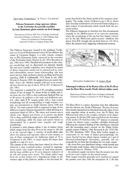
The Palinuro Seamount, located in the southeast Tyrrhenian<br />
sea (Central Mediterranean) about 80 km offshore the<br />
coasts of Campania Region, is a wide volcanic complex<br />
due to Plio-Quaternary faults connected to the extension<br />
of the Tyrrhenian basin (Barberi & alii, 1974; Beccaluva &<br />
alii, 1984; Serri 1990). Detailed informartions on the volcanic<br />
morphology and on discovered ore deposits (mainly<br />
Mn and some metallic sulphides) were obtained by means<br />
of direct inspections carried out by manned and un- manned<br />
submersibles, narrow beam echosounding, side scan<br />
sonar surveys, high resolution seismic profiling and bottom<br />
sampling (Selli & Gabbianelli, 1979; Rossi & alii, 1980;<br />
Minniti & Bonavia 1984). Its sampled lavas are mainly tholeitic.<br />
Some calc- alkaline samples collected on its summital<br />
area showed an age of about 350 ky B.P. (Colantoni &<br />
alii, 1981).<br />
The seamount is marked by an E-W prevailing extension<br />
(about 55 km of length Vs. about 30 km of width) and rises<br />
from the over 3200 m deep tyrrhenian Bathyal Plain up<br />
to 80 metres. In addition to the main and shallowest summit,<br />
other eight E-W ranging peaks with a clear conical<br />
morphology and all corresponding to single eruptive centers,<br />
are encountered at depth between about 1300 and<br />
500 m. The main summit itself is composed at least of two<br />
different eruptive features separated by a little sill lying at a<br />
maximum depth of 180 m. The minor and western one is<br />
clearly cone- shaped and shows, at its narrow top about<br />
136 m deep, radial little ridges and a well recognizable erateric<br />
morphology, while the major and eastern feature is<br />
characterized by a general more complex and rough<br />
morphology.<br />
It presents a wide plateau (about 3 km of radius) whose<br />
depth ranges from less than 80 m at the center to 100-120<br />
m at the external edges. A number of small reliefs raise<br />
above the plateau and represent relics of wave erosion; to<br />
one of these corresponds the shalloweat depth of 70 m<br />
(Colantoni & alii, 1981). At major depths the slopes deep<br />
rapidly at a rate of 1 to 2.<br />
The summit of the volcano has been visited by divers that<br />
observed a clear erosional surface, covered by organogeneous<br />
sands, with rough outcrops of hard lavas surrounded<br />
by large cobbles up to 30 em in diameter, indicative of<br />
an old and strong wave action. The debris pulled away<br />
from the eroded surface fed a depositional wedge on the<br />
western edge of the platform, similar to the low-stand de-<br />
posits described in the classic model of the sequence stratigraphy.<br />
The wedge, whose thickness is up to 40 m, shows<br />
clear downlap terminations and internal foresets lying on a<br />
slant surface of unconformity which stretch forth the erosional<br />
surface.<br />
The Palinuro Seamount is therefore the first documented<br />
example in the Mediterranean of an open-sea seamount,<br />
where the morphology of the top has been largely controlled<br />
by the late Pleistocene glacio-eustatic variations that<br />
about 18 ky B.P. brought the sea level down to 110-130 m<br />
below the present level, triggering widespread erosions.<br />
GIOVANNI GABBIANELLI & CARLOELMI<br />
Submerged evidences of the Roman delta of the Po River<br />
near the Reno River mouth (North Adriatic italian coast)<br />
Dipartimento di Scienze della Terra e Geologico- Ambientali,<br />
Universita di Bologna, via Zamboni, 67, 40127 Bologna, Italy<br />
The Reno River is a minor Apennine river that debouches<br />
into the Adriatic sea, North of Ravenna. The area of its modern<br />
mouth represented in historical times the place of two<br />
wide cuspidate deltas of another river, the Po River, that<br />
followed each other in the complex evolution of its dispersing<br />
system. In the last 2500 years and before the formation<br />
of the modern Po bird-foot delta (17 th century to present),<br />
at least ten distinct major cuspidate subdeltas developed,<br />
following the repeated shifting of the distributary channels<br />
and the increasing man's control on the Padan hydrographic<br />
system (Ciabatti, 1966; Roncuzzi & alit: 1970; Fabbri<br />
1985, Bondesan 1989). These delta bodies, largely reconstructed<br />
on the basis of inland geomorphologic elements<br />
(buried barriers island, lagoon remains etc.) and of<br />
historical-archaeological information, generally did not<br />
prograde far out from the shorelines for two main causes:<br />
- the rivers flow was distributed along a wide frontal area<br />
and through small outlets, delta interlagoonal areas, interdistributary<br />
bay etc. (Nelson, 1970);<br />
- the sediment supply was lower than the present one, due<br />
to the low man's impact on the natural system.<br />
Their largest extension generally never reached nor passed<br />
the present coast line, with the exceptions of: i) the late<br />
173


