

ABSTRACTS / RESUMES - Comitato Glaciologico Italiano
ABSTRACTS / RESUMES - Comitato Glaciologico Italiano
ABSTRACTS / RESUMES - Comitato Glaciologico Italiano

You also want an ePaper? Increase the reach of your titles
YUMPU automatically turns print PDFs into web optimized ePapers that Google loves.
JOHN D. JANSEN & GARY J. BRIERLEY<br />
Late Holocene superfloods and riffle-pool morphodynamics<br />
in an arid zone gorge, Barrier Range, Australia<br />
School of Earth Sciences, Macqarie University, 2109, Sydney, Australia<br />
Riffle-pool landform assemblages provide useful insights<br />
into river behaviour and history in arid zone bedrock-confined<br />
valleys. Rather than simply focus on the magnitude<br />
and frequency of individual 'superfloods' through time,<br />
this study characterizes process-form relationships over the<br />
full spectrum of flow magnitudes: from superflood boulder-trains<br />
of imbricated clasts >2m in diameter, down to<br />
low-energy mud facies in ephemeral waterholes. Detailed<br />
stratigraphic and sedimentologic analyses, combined with<br />
radiocarbon dating have revealed an 1800-year alluvial history<br />
characterized by event-driven disequilibrious behaviour:<br />
three major erosional flood-episodes interspersed by<br />
long periods of relative quiescence and fine-grained sedimentation.<br />
Sandy Creek gorge dissects a 60 km 2 upland catchment on<br />
the north-eastern flank of the Barrier Range in arid far western<br />
New South Wales, Australia. The well defined rifflepool<br />
sequence strongly reflects structural control. A string<br />
of ephemeral pools (waterholes), each occupying valley<br />
constrictions 30-40 m wide correspond to resistant bedrock<br />
obstructions. Pools lie within convergent flow-scoured<br />
troughs up to 4.5 m below adjoining riffles and comprise<br />
bed materials of coarse sands and granules. Riffles<br />
are situated in flow-divergent valley expansions 60-80 m<br />
wide, marked by lobate boulder bars with median clast-sizes<br />
of 0.2-0.4 m, although some imbricated boulders exceed<br />
2.5 m in diameter.<br />
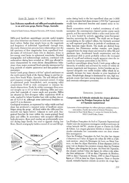
Geological structure, as expressed by valley width and bed<br />
slope has produced a repeated series of landform assemblages<br />
along the gorge - all fixed within the riffle-pool framework<br />
(see figure below). Adjacent to each pool, finegrained<br />
benches lie inset within the coarse-grained flood<br />
plain and riffles. In accordance with accepted riffle-pool<br />
hydrodynamics, these pool reaches are preferentially scoured<br />
during large floods, but tend to aggrade during low<br />
flows. Bench stratigraphy holds a record of cut and fill epi-<br />
BEDROCK<br />
sodes dating back to the last superflood clear out (>1800<br />
a), when extreme bed shear stresses (>500 Nm- 2 ) generated<br />
would have destroyed benches and caused scour to bedrock.<br />
Bench excavations reveal a marked consistency of sedimentation:<br />
the contemporary channel carries coarse sandy<br />
gravels, and lies entrenched within a relict mud facies which<br />
is now buried by actively aggrading (post-European)<br />
benches narrowing the channel. The muds are no longer<br />
accumulating in the upland valleys, but formerly accreted<br />
on well vegetated pool floors in periods of catchment stability<br />
between major floods. The muds are derived from<br />
extensive late Pleistocene aeolian mantles, now largely<br />
stripped from the steep slopes and stored in valley fills and<br />
piedmont fans. Accelerated bench construction and the<br />
depositional shift in pools probably reflects the increased<br />
rates of runoff and sediment supply apparent since the invasion<br />
by European pastoralists in the 1870's.<br />
Landform assemblages along Sandy Creek gorge reflect an<br />
hierarchy of stability and activation by events of widely disparate<br />
magnitude and frequency. Active benches are juxtaposed<br />
alongside very stable boulder riffles which lie essentially<br />
dormant for many decades or even hundreds of<br />
years. Morphologic change is dominated by rare, high magnitude<br />
events that leave strong imprints on the landscape<br />
and constrain subsequent processes.<br />
EMMANUEL JAURAND<br />
Comparaison de I'altitude minimale des cirques glaciaires<br />
entre les Prealpes francaises du Sud<br />
et I'Apennin septentrional<br />
Laboratoire «Geomorphologie des milieux physiques mediterraneens et<br />
semi-arides», Faculte des Lettres et Sciences Humaines,<br />
Universite de Paris-Val-de Marne, 61 avenue du General de Gaulle,<br />
94010 Creteil Cedex, France<br />
Les Prealpes Francaises du Sud et l'Apennin Septentrional<br />
(Italic) sont des moyennes montagnes mediterraneennes de<br />
meme latitude (44°N) , situees de part et d'autre du Golfe<br />
de Genes. Les cirques glaciaires herites se situent a des altitudes<br />
minimales fort contrastees entre ces deux ensembles<br />
montagneux.<br />
Dans les Prealpes Francaises du Sud, les plus bas cirques<br />
s'observent sur 1'ubac de lignes de cretes de 1900 m d'altitude<br />
environ: ainsi ala Montagne de Lure, au Mont Ventoux,<br />
ou dans les Alpes Maritimes. II faut depasser 2100 m<br />
pour voir se des siner les premiers cirques dans les Prealpes<br />
de Digne, plus eloignees de la mer. Au Nord de 1'Apennin,<br />
des cirques ourlent 1'ubac des lignes de cretes a des altitudes<br />
bien interieurcs : 1700 m dans l'Apennin de Modene,<br />
1600 m dans 1'Apennin de Parme, 1500 m dans 1'Apennin<br />
ligure et 1350 m dans les Alpes Apuanes. Dans ce dernier<br />
massif, veritable barriere dressee en arriere du rivage ligu-<br />
219


