

ABSTRACTS / RESUMES - Comitato Glaciologico Italiano
ABSTRACTS / RESUMES - Comitato Glaciologico Italiano
ABSTRACTS / RESUMES - Comitato Glaciologico Italiano

You also want an ePaper? Increase the reach of your titles
YUMPU automatically turns print PDFs into web optimized ePapers that Google loves.
pass with a duckfoot chisel, expressed by the diffusion<br />
constant (k), equals 282 kg/m for up and downslope tillage<br />
and only 139kg/m for contour tillage. Nomograms indicate<br />
that mean denudation rates in almond groves due to tillage<br />
erosion (3 to 5 tillage passes per year) can easily amount to<br />
1.5 - 2.6 mm/year for contour tillage and up to 3.6 - 5.9<br />
mm/year for up- and downslope tillage for a field, 50 m<br />
long and having a slope of 20 0/0. These figures are at least<br />
one order of magnitude larger than reported denudation<br />
rates caused by water erosion in similar environments.<br />
Hence tillage erosion contributes significantly to land degradation.<br />
The downslope soil flux induced by tillage not<br />
only causes considerable denudation on topographic convexities<br />
(hill tops and spurs) and upper field boundaries<br />
but also an important sediment accumulation in topographic<br />
concavities (hollows and valley bottoms) and at<br />
lower field boundaries. Kinetic sieving (i.e. the upward migration<br />
of rock fragments) by the tines of the duckfoot chisel<br />
also concentrates the largest rock fragments in the topsoil<br />
in such a way that a rock fragment mulch develops in<br />
narrow valleys and at the foot of the slopes.<br />
These results clearly indicate that tillage erosion is the<br />
main process responsible for the observed rock fragment<br />
cover pattern in the study area. Since the study area is representative<br />
for many parts of the Mediterranean where almond<br />
groves have expanded since 1970, the results have a<br />
wider application. They show to what extent intensive tillage<br />
of steep slopes has contributed to the increase in soil<br />
degradation, to changes in hillslope morphology (i.e.<br />
strong denudation of convexities, development of lynchets<br />
and rapid infilling of narrow valley bottoms) and to the development<br />
of patterns of leptosols and of rock fragment<br />
cover which control the spatial variability of the hydrological<br />
and water erosion response within such landscapes.<br />
NATALIA PONIATOVSKAIA<br />
L'annalyse geomorphologique de l'aire urbaine de Moscou<br />
Departement de Geographie, Universite d'Etat «M. V. Lomonosov»,<br />
Colline de Lenin, 119899 Moscou, Russie<br />
L' aire urbaine de Moscou, comme toute autre partie de la<br />
surface terrestre, occupe une certaine position geographique,<br />
presente certaines caracteristique du relief et une<br />
somme de processus geomorphologiques. Acause du fort<br />
impact d'un complexe de facteurs techno-genetiques, elle<br />
devient un facteur essentielqui produit un effet apreciable<br />
sur l' atmosphere, hidrosphere, biosphere et lithosphere,<br />
effet qui depasse beaucoup les dimensions de la ville proprement-dite.<br />
En coexistant sous les memes conditions climatique et<br />
structural-tectoniques, les composants naturels et technogeneriques<br />
se developpent en etroit contact, entre eux existant<br />
des interrelations et des interactions varices:<br />
314<br />
- des relations naturelles, historiques, genetiques et dynamiques<br />
entre les elements du milieu geologique-geographique;<br />
- echange hydrodynamique entre les elements naturels et<br />
les composants techno-genetiques, qui implique les precipitations,<br />
les eaux de surface et souterrains et les acumulations<br />
liquides. Dans la ville l'echange de l'eau functionne<br />
en meme temps par des voies naturelles (precipitationsdrainage)<br />
et par des instalations hydrotechniques (conduits,<br />
systemes de collection et drainage etc.);<br />
- «engineer» relations, comme l'ecoullement hydrodynamique<br />
dirige par constructions hydrotechniques, et en<br />
plus, des relations entre topographie, hidrosphere, atmosphere<br />
et differentes installations d'ingenierie,<br />
Tous ces relations entre les elements naturels et technogenetiques<br />
du milieu urbain peuvent etre en caractere direct<br />
ou inverse, les objets naturels etant plutot passifs, en<br />
temps que ceux techno-genetiques-plutot actifs.<br />
MARION B. POTSCHIN & HARTMUT LESER<br />
Geomorphological processes and sediments modifying<br />
geoecological conditions in the High Arctic<br />
(N orthwest-Spitsbergen)<br />
Department of Geography, University of Basel,<br />
Spalenring 145, CH-4055 Basel, Switzerland<br />
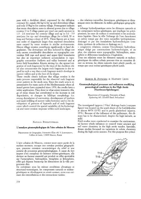
The investigated (approx.) 5 km 2 drainage basin (compare<br />
figure) was located on the south shore of the Liefdefjorden<br />
at almost 80 0N (13°E) and is partly glacierised (approx,<br />
35 0/0). Because of the influence of the gulfstream, the climate<br />
has to be characterised, despite the high latitude, as<br />
mild.<br />
Field studies were conducted to examine the environmental<br />
factors which influence or control water amount and<br />
soil water chemistry in the high arctic tundra. Specially,<br />
theses studies focussed on variations in solute chemistry<br />
during the high arctic seasons. For this purpose five princi-


