

ABSTRACTS / RESUMES - Comitato Glaciologico Italiano
ABSTRACTS / RESUMES - Comitato Glaciologico Italiano
ABSTRACTS / RESUMES - Comitato Glaciologico Italiano

You also want an ePaper? Increase the reach of your titles
YUMPU automatically turns print PDFs into web optimized ePapers that Google loves.
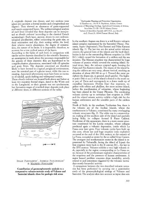
A «typical» deposit was chosen, and two sections were<br />
taken into account: a frontal section and a longitudinal one<br />
(figure). They showed an alternance of grain-supported<br />
and matrix-supported layers ..The sedimentological analysis<br />
of each level revealed that these deposits can be interpreted<br />
as eboulis ordonne (according to the classical French<br />
terminology). Each layer, anyway, shows its own sedimentological<br />
peculiarities, either concerning the grain size, or<br />
their orientation and dip, their sorting within the level,<br />
their relative matrix abundance, the degree of cementation,<br />
the nature of its limits. It is impossible, therefore, to<br />
account for a true cyclical nature of the layers.<br />
According to the facies of each level, in comparison with<br />
similar active deposits described in the scientific literature,<br />
an assumption is made about the processes responsable for<br />
the genesis of these deposits: they are hypothized to be<br />
congeliturbation phenomena, associated with rill episodes<br />
and grain flows. The deposits concerned are therefore<br />
likely to have formed in a typical periglacial environment,<br />
near the terminal part of a glacier snout, while this was retreating.<br />
Associated phenomena must have been an increase<br />
of rainfall, quick melting and widespread erosion.<br />
These eboulisordonne are located both above and below at<br />
least two morainic frontal ridges, dated to the Wiirm and<br />
to the Lateglacial; so their genesis was not synchronous,<br />
but formation stages of stratified slope deposits took place<br />
at different times, in different sections of the valley.<br />
()<br />
I<br />
m<br />
ISSAAK PARCHARIDIS 1, ANDREAS PAVLOPOULOS 2<br />
& MAURIZIO POSCOLIERI 3<br />
Contribution of geomorphometric analysis to a<br />
comparative volcano-tectonic study of Vulcano and<br />
Santorini islands: clues for geologic risk areas<br />
1 Earthquake Planning and Protection Organization,<br />
. 32 Xanthou str., 15451 N. Psychicon, Athens, Greece<br />
2 Laboratory of Mineralogy-Geology, Agricultural University of Athens,<br />
Iera Odos 75, GR- 11855 Athens, Greece<br />
3Istituto di Astrofisica Spaziale del C.N.R., p.p. box 67,<br />
via E. Fermi 21,00044 Frascati (Roma), Italy<br />
In the southern Aegean sea there is a well known volcanic<br />
island complex represented by the Santorini (Thera), Therassia,<br />
Aspro (Aspronissi), Nea Kameni and Palea Kameni<br />
islands (fig. 1). The last two are the actual active volcanic<br />
centers; the general form of the islands and the land distribution<br />
is due to the outstanding Minoan eruption (ca 1500<br />
B.C.) which caused the formation of a caldera and the sea<br />
invasion. The Minoan eruption was characterized by huge<br />
volumes of pumice which covered the existing island. Several<br />
times, later, the volcano erupted again forming the<br />
Palea and Nea Kameni islands. The slopes of the island facing<br />
the caldera are very steep, almost vertical, reaching an<br />
elevation of about 200-300 m a.s 1. Toward the outer periphery<br />
the slopes are, in general, much gentler. The highest<br />
point (566 m a.s.l.) of the island is found in the south east<br />
part of Thera and corresponds to a dome made up of<br />
crystalline limestones (Profitis Ilias) that represent, together<br />
with schists and phyllites, the more ancient island,<br />
before the manifestation of volcanism, whose beginning<br />
has been placed in the Upper Pliocene. The continuing<br />
volcanic activity up to nowadays (last eruption in 1950)<br />
and the related seismic activity exhibit a high risk for the<br />
human settlements and the unstable parts of the caldera<br />
walls.<br />
North of Sicily, in the southern Tyrrhenian Sea, there is<br />
the. volcanic arc of the Aeolian Islands, whose the<br />
southernmost is Vulcano, constituted by many overlapping<br />
volcanic structures (fig. 2). The older one is a stratovolcano,<br />
making all the southern side of the island and partially<br />
facing Sicily; its collapse formed II Piano Caldera.<br />
Northwest of this apparatum, there is a more recent structure<br />
constituted by the Lentia complex, whose collapse<br />
produced again a volcanic depression, inside which La<br />
Fossa cone later grew. Four volcanic cycles have built up<br />
this cone, whose last and huge eruption (only explosive)<br />
occurred at the end of the 19th century at the summit of<br />
La Fossa, occupied at center by the so called Gran Cratere.<br />
The youngest and northernmost center in the island is represented<br />
by Vulcanello, facing the island of Lipari: the<br />
first eruption dates back to the II century B.C., the last to<br />
the XVI century. Vulcano exhibits a very high volcanic risk,<br />
especially in the region corresponding to La Fossa cone,<br />
because of the predominant explosive characteristics of<br />
the eruptions and the presence of human settlements. A<br />
major hazard problem concerns slope instability, strictly<br />
related to and sometimes triggered by the volcanic (nowadays<br />
mostly fumarolic) activity.<br />
A comparison between the two described volcanic scenarios<br />
has been performed by carrying out a quantitative<br />
study of the geomorphological settings of Vulcano and<br />
Santorini. The analysis takes into account as input data sets<br />
303


