

ABSTRACTS / RESUMES - Comitato Glaciologico Italiano
ABSTRACTS / RESUMES - Comitato Glaciologico Italiano
ABSTRACTS / RESUMES - Comitato Glaciologico Italiano

You also want an ePaper? Increase the reach of your titles
YUMPU automatically turns print PDFs into web optimized ePapers that Google loves.
st Glacial vegetation rather than the degree of temperature<br />
depression.<br />
Reconstruction of the vegetation map of Japan at the Last<br />
Glacial Maximum has been attempted by several researchers.<br />
They yielded different results, since data and criteria<br />
for map compilation were not identical. One of the maps<br />
was compiled based on the distribution of existing life, as<br />
some kinds of life closely related to vegetation types have<br />
scarcely widened their territories since the Last Glacial<br />
Maximum. The map demonstrates that treeless and/or<br />
sparse forest areas broadly occurred in the lowlands of western<br />
Japan and south Korea. These areas agree well with<br />
distribution of fossil periglacial landforms. In addition,<br />
these areas are thought to have low potential for tree<br />
growth because of two reasons. First, half of the areas correspond<br />
to the distribution of recent tree less mountains<br />
(Hageyama in Japanese) which were human-triggered but<br />
have been maintained owing to an unfavorable physical<br />
settings such as slope form, geology, and climate. Second,<br />
the other half of the areas are in the proximity of active<br />
volcanoes, and thus were subjected to frequent fall of<br />
tephras during the Last Glacial. These correlations validate<br />
the applicability of the vegetation map. Moreover, most of<br />
the treeless and/or sparse forest areas have small amounts<br />
of snow in winter, giving weak protection against freezethaw<br />
action. The condition of little snow also applied to<br />
the Last Glacial, because the winter atmospheric pressure<br />
pattern ofJapan has been basically unchanged since then.<br />
In summary, factors including slope form, geology, climate<br />
and frequent fall of volcanic ash worked together to lower<br />
the land potential for tree growth in the lowlands. This<br />
caused recession of thick forestation in spite of temperatures<br />
high enough for tree growth, resulting in strong freezethaw<br />
action during cold seasons. Thin snow cover in winter<br />
also facilitated the occurrence of periglacial landforms.<br />
The landforms are located far below the Last Glacial treeline<br />
determined by temperature, and thus can be called<br />
«extrazonal». Such extrazonallandforms, however, developed<br />
in broad zones of western Japan and Korea.<br />
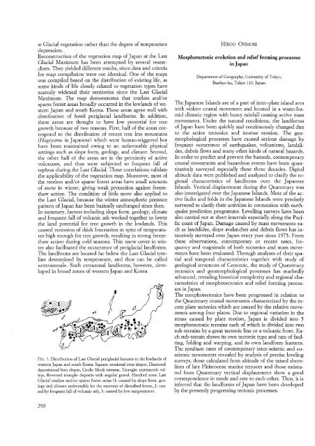
FIG. 1. Distribution of Last Glacial periglacial features in the lowlands of<br />
western Japan and south Korea. Square: erosional crest slopes, Diamond:<br />
depositional foot slopes, Circle: block streams, Triangle: asymmetric valleys,<br />
Reversed triangle: deposits with angular gravel. Hatched zone: Last<br />
Glacial treeless and/or sparse forest areas (1: caused by slope form, geology<br />
and climate unfavorable for the recovery of disturbed forest, 2: caused<br />
by frequent fall of volcanic ash, 3: caused by low temperature).<br />
290<br />
HIROO OHMORI<br />
Morphotectonic evolution and relief forming processes<br />
in Japan<br />
Department of Geography, University of Tokyo,<br />
Bunkyo- ku, Tokyo 113, Japan<br />
The Japanese Islands are of a part of inter-plate island arcs<br />
with violent crustal movement and located in a warm-humid<br />
climatic region with heavy rainfall causing active mass<br />
movements. Under the natural conditions, the landforms<br />
of Japan have been quickly and continuously changed due<br />
to the active tectonics and intense erosion. The geomorphological<br />
processes have caused serious damage by<br />
frequent occurrence of earthquakes, volcanisms, landslides,<br />
debris flows and many other kinds of natural hazards.<br />
In order to predict and prevent the hazards, contemporary<br />
crustal movements and hazardous events have been quantitatively<br />
surveyed especially these three decades. Digital<br />
altitude data were published and analyzed to clarify the regional<br />
characteristics of landforms over the Japanese<br />
Islands. Vertical displacement during the Quaternary was<br />
also investigated over the Japanese Islands. Most of the active<br />
faults and folds in the Japanese Islands were precisely<br />
surveyed to clarify their activities in connection with earthquake<br />
prediction programme. Levelling surveys have been<br />
also carried out at short intervals especially along the Pacific<br />
coast of Japan. Damage caused by mass movements such<br />
as landslides, slope avalanches and debris flows has intensively<br />
surveyed over Japan every year since 1975. From<br />
these observations, contemporary or recent rates, frequency<br />
and magnitude of both tectonics and mass movements<br />
have been evaluated. Through analyses of their spatial<br />
and temporal characteristics together with study of<br />
geological structures of Cenozoic, the study of Quaternary<br />
tectonics and geomorphological processes has markedly<br />
advanced, revealing historical complexity and regional characteristics<br />
of morphotectonics and relief forming processes<br />
in Japan.<br />
The morphotectonics have been progressed in relation to<br />
the Quaternary crustal movements characterized by the recent<br />
plate tectonics which are caused by the relative movements<br />
among four plates. Due to regional variation in the<br />
stress caused by plate motion, Japan is divided into 5<br />
rnorphotectonic terrains each of which is divided into two<br />
sub-terrains by a great tectonic line or a volcanic front. Each<br />
sub-terrain shows its own tectonic type and rate of faulting,<br />
folding and warping, and its own landform features.<br />
The resultant rates of contemporary inter-seismic and coseismic<br />
movements revealed by analysis of precise leveling<br />
surveys, those calculated from altitude of the raised shorelines<br />
of late Pleistocene marine terraces and those estimated<br />
from Quaternary vertical displacement show a good<br />
correspondence in mode and rate to each other. Thus, it is<br />
inferred that the landforms of Japan have been developed<br />
by the presently progressing tectonic processes.


