

ABSTRACTS / RESUMES - Comitato Glaciologico Italiano
ABSTRACTS / RESUMES - Comitato Glaciologico Italiano
ABSTRACTS / RESUMES - Comitato Glaciologico Italiano

You also want an ePaper? Increase the reach of your titles
YUMPU automatically turns print PDFs into web optimized ePapers that Google loves.
On the Po Valley side, the evolution of the river net that<br />
formed on a Plio-Pleistocene pediment was determined by<br />
the particular structural context: owing to the presence in<br />
central Piedmont of the outer fingers of the rising Apennines'<br />
two distinct areas offered routes for the drainage of<br />
southern Piedmont. The Turin corridor took advantage of<br />
the structural trough between the Alps and the Apennines,<br />
and was the drainage path followed by all the Alpine watercourses<br />
starting from the present Bormida di Millesimo<br />
and Bormida di Spigno during the Lower Pleistocene, while<br />
the Alessandria area, a depression in the Apennines<br />
between the Monferrato district and the Ligurian section<br />
of the Apennines, formed the outlet for the smaller streams<br />
running down the easternmost sector of the Langhe pediment,<br />
The Turin route was initially favoured by its better<br />
structural position, but gradually deteriorated throughout<br />
the Pleistocene due to the progressive obstruction of the<br />
Turin rock bar between the tectonically uplifting Turin<br />
Hills and the initially fluvial and then fluvioglacial fan of<br />
the Dora Riparia coated with enormous moraines by each<br />
glaciation, and hence in steep progradation despite its erosion<br />
by the Po. During the Upper Pleistocene - Lower Holocene,<br />
this evolution culminated in the changes in the<br />
Piedmontese drainage pattern known in the literature as<br />
the «capture of the Tanaro». The subsequent erosion phase<br />
gave the present Langhe their cuesta shape, though in<br />
their southern section the almost total wearing away of the<br />
Oligocene marine deposits has resulted in partial exhumation<br />
of the Oligocene morphology. Along the Ligurian<br />
Adriatic watershed, on the other hand, the head of the<br />
Pleistocene watercourses, once tributaries of the Alessandrine<br />
plain, were altered by the development of a net with<br />
a rectangular pattern determined by fault systems that were<br />
also the cause of the progressive tectonic subsidence of<br />
the Ligurian side, and hence of the northward displacement<br />
of the watershed itself, with the gradual shearing of<br />
the heads of the Padane rivers to the east of the Cadibona<br />
Pass, in keeping with the characteristic morphotectonic<br />
style of the Ligurian section of the Apennines.<br />
In the Alpine area, the most significant event during the<br />
Pleistocene was the transition from the ancient WNW<br />
drainage pattern to the present net, whose main river (the<br />
Tana-to) runs northwards along a structurally and morphologically<br />
low zone that probably formed during the Lower<br />
Pleistocene through reactivation of direct faults already<br />
present in the Middle Oligocene. The Alpine area was also<br />
affected by the elevation in relief energy associated with<br />
the capture of the Tanaro, resulting in a marked increase<br />
in erosion, except where karstification transformed fluvially<br />
modelled areas into poljes or causses.<br />
On the Ligurian side, too, the paths of valleys that had formed<br />
along the ancien pediments were different in the<br />
Lower Pleistocene to those they have today. In the Finale<br />
area, where their evolution can be reconstructed with a<br />
good degree of approximation, there are interesting signs<br />
of competition with the karstification process: initially the<br />
rivers ran round the major karsts, which formed causses,<br />
whereas later they were captured by underground complexes<br />
within the caussess and ended up by forming nar-<br />
80<br />
row, boxed-in valleys, some of which were shaped in the<br />
Lower Pleistocene and then abandoned, and have been<br />
preserved until the present as relicts. During the Quaternary,<br />
the fluvial morphogenesis of the whole of the Ligurian<br />
side has experienced periods, which probably correspond<br />
to positive eustatic oscillations, when the valleys became<br />
much wider with flat floors linked to hillside terraces,<br />
alternating with periods, such as the present, in which<br />
the recommencement of relative uplifting is the cause of a<br />
deep incision in the river net, with the shaping of a rather<br />
harsh landscape.<br />
ALESSANDRO BIASINI 1, VALENTINA CAMPO 2,<br />
PIER FRANCESCO GRANGIE 3 & MARIA CRISTINA SALVATORE 1<br />
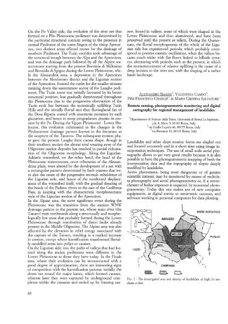
Remote sensing, photogrammetric monitoring and digital<br />
cartography for regional management of landslides<br />
1Dipartimenta di Scienze della Terra, Universita di Rama La Sapienza,<br />
p.le A. Mora 5, 00185 Rama, Italy<br />
2 via Emilio Lepido 46, 00175 Rama, Italy<br />
3 via Ruzzante 10, 00145 Rama, Italy ,<br />
Landslides and other slope erosion forms are singled out<br />
and located accurately and in a short time using image interpretation<br />
techniques. The use of small scale aerial photographs<br />
allows to get very good results because it is also<br />
possible to have the photogrammetric mapping of both the<br />
interpretation data and the topography of slopes deeply<br />
modified by landslides.<br />
Active phenomena, being most dangerous or of greater<br />
scientific interest, may be monitored by means of multidata<br />
photography and aerial photogrammetry or, if a retrenchment<br />
of futher expenses is required, by terrestrial photogrammetry.<br />
Today this one makes use of new computer<br />
equipments, as digital metric or semimetric cameras, and<br />
software working in personal computers for data plotting.<br />
LAZIO<br />
ABRUZZO<br />
MARE ADRIATICO<br />
FIG. 1 - The investigated area and density of landslides: a) high; b) medium;<br />
c) low.<br />
';<br />
\.<br />
\


