

ABSTRACTS / RESUMES - Comitato Glaciologico Italiano
ABSTRACTS / RESUMES - Comitato Glaciologico Italiano
ABSTRACTS / RESUMES - Comitato Glaciologico Italiano

Create successful ePaper yourself
Turn your PDF publications into a flip-book with our unique Google optimized e-Paper software.
per streams. In DEM-based networks, more than two<br />
streams confluent simultaneously. Therefore, the streams<br />
which have maximum stream order are joining on same time,<br />
stream order of after joining is increased.<br />
Rs = 4.27 and RI= 1.89 is obtained for average bifurcation<br />
ratio (Rb) and average stream length ratio (RI) of manualextracted<br />
drainage 1, respectively. These results agree with<br />
results of other studies treating Japanese rivers (for example,<br />
Tokunaga, 1966). On the contrary, Rb is bigger and Rl<br />
is smaller than that of manual-extracted networks, respectively,<br />
for All Order Type, (Rb =5.93 and RI= 1.69), VI =<br />
10 Type (Rb= 5.35 and RI= 1.76) (figs. 1 and 3). This is<br />
caused by All Order Type and VI = 10 Type simulate too<br />
many 1st. order streams than manual-extracted networks.<br />
This means All Order Type and the threshold value VI =<br />
10 cannot eliminate the valleys or gullies which are not represent<br />
on the topographical maps. About stream numbers,<br />
the number of VI =27 show the best agreement with<br />
manual-extracted networks (fig. 2). However, the stream<br />
length of VI = 27 agree only that of 2nd. and 3rd. order<br />
streams (fig. 3). These differences may be caused by locations<br />
where stream starts. The uppermost points of these<br />
are regarded as stream heads in this study, but not always<br />
the case in real. The length of 1st. order streams, therefore,<br />
are estimated irregularly. The further study will take this<br />
problem into account.<br />
VLADIMIR N. NEVSKY<br />
Do isostasy and rotational regime control relief evolution<br />
of continental margins? "<br />
Pacific Institute of Geography, Radio st. 7, Vladivostok, 690041, Russia<br />
Can Earth's surface processes influence geotectonics? The<br />
common answer has been done in hypothesis of denudation-accumulative<br />
and glacio isostasy. Its main principles<br />
have to be corrected according to recent geophysics and<br />
paleogeography data.<br />
As is known surface mass movement both and water-ice<br />
transformation causes asthenosphere compensation in sublateral<br />
directions. All these inner and outer processes are<br />
connected dynamically by means of Earth's rotational regime<br />
such as polar wandering and Earth's flattering. There is<br />
the interesting fact: R-polarity geomagnetic excursions during<br />
Brunhes epoch correlate chronologically with fluctuations<br />
of north continental ice volume much better, than<br />
with some another processes. In other words north ice coves<br />
and rotational parameters change due to glacioisostasy<br />
are very probable causes of short-term geomagnetic events.<br />
Secondly, locality of some island arcs is assumed to correspond<br />
to ancient sedimentary basins of the most large rivers.<br />
For instance the L. Antilles arc corresponds to Paleogene<br />
accumulation basin of South America rivers of north<br />
direction. Pacific arc Ryukyu has been formed near abyssal<br />
fans of Paleogene -Neogene Great China streams. These<br />
processes are supposed to be caused by extremely high<br />
gradients of mass balance on continent-ocean boundary<br />
near abyssal sedimentary basins of large rivers. As is postulated<br />
lithosphere is of mainly compression and fracturing<br />
conditions, so the most probable result of denudation-accumulative<br />
isostasy at the boundaries is a subduction. Rifting<br />
has a passive role. Subduction of west Pacific type develops<br />
under superposition of compensative and global east<br />
(according to Nelson and Temple) asthenosphere flows<br />
together with opposite vertical movement of interacted<br />
blocks. Subsequently the relief of continental margins is<br />
reformed. Island arc and margin seas must be regarded as<br />
obligatory effect, whereas continental relief has different<br />
variants of evolution. In the first case ancient river network<br />
is quite reoriented as it was in North-East Asia. In another<br />
case network can save its structure, but accumulation basins<br />
remove upwards as in Central East China.<br />
ANDREI A. NIKONOV & A.P. SERGEEV<br />
Identification and quantification of seismogravitational<br />
relief disturbances: the caucasian mountain<br />
area as an exsample<br />
Joint Institute of Physics of the Earth, Acad. Sci. Russia.<br />
Bol. Gruzinskaya 10, 123810 Moscou, Russia<br />
In contrast to seismotectonic ruptures, seismogravitational<br />
relief disturbances (slope movements due to earthquakes)<br />
have so far received quite insufficient attention. There are<br />
some unresolved problems. The following ones are considered<br />
in this paper:<br />
Discrimination seismogravitational disturbances proper as<br />
distingnished from pure gravitational ones. Six features of<br />
seismogravitational slope disturbances are identified.<br />
7.i I.i '.i<br />
...----f-----+---+---.....----+.<br />
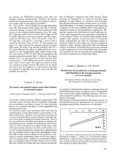
FIG. 1 - Quantitative correlations between recent big bedrock seismodeformations<br />
on slopes (V - volume in m) and parametres of related<br />
earthquakes (I - intensity) of the Caucasus have been derived (see Fig.).<br />
This was used to make an attempt to resolve the inverse problem, namely,<br />
to assess the intensity and magnitudes of past strong earthquakes<br />
from dimensions of relevant deformations.<br />
287


