

ABSTRACTS / RESUMES - Comitato Glaciologico Italiano
ABSTRACTS / RESUMES - Comitato Glaciologico Italiano
ABSTRACTS / RESUMES - Comitato Glaciologico Italiano

Create successful ePaper yourself
Turn your PDF publications into a flip-book with our unique Google optimized e-Paper software.
north it is limited by the Dauki fault and to the east by the<br />
marginal faults of the Barail ranges. Naga-Lushai-Arakan<br />
Yoma Folded Belts: This is an elongate crescent-shaped<br />
belt extending from the Bay of Bengal to the Mishmi block<br />
in a N-S, NNE-SSW ot NE-SW direction. It is characterised<br />
by parallel ridges and valleys, rugged and intensely dissected<br />
topography and parallel and dendritic drainage.<br />
Likwise, the Bengal - (Brahmaputra) basin is characterised<br />
by flat lying, even and mottled textured terrain with low<br />
relief and anastomosing drainage pattern. The NW-SE<br />
trending lineaments are very prominent running almost parallel<br />
to the stream courses viz. Padma lineament, Jamuna<br />
lineament, Tista lineament etc. Used in conjunction with<br />
discontinuous data in terrains of poor access, this synoptic<br />
medium provides a powerful tool for tectonic analysis.<br />
Boundaries of such tectonic zones, thus identified, are<br />
marked by pronounced lineaments, either straight or curved.<br />
Lineaments of significance include the Dauki fault, Jamuna<br />
lineament, Tista and Padma lineaments, Main boundary<br />
fault of the Himalaya, Siang fracture, Tsangpo suture,<br />
Mishmi and Lohit thrusts, Naga and Disang thrusts, Axial<br />
zone, Volcanic line of Burma, Red river faults, etc. Lineaments<br />
passing from GangaBrahmaputra delta across the<br />
Himalaya to Tibet must be the expression of deep-seated<br />
and fundamental crustal fractures, but are possibly of geologically<br />
recent origin as evidenced from their manifestation<br />
through the recent river deposits of the Bengal basin.<br />
The entire area is representative of a conspicuous polycylic<br />
landscape with diversified soil - landform - drainage types.<br />
The seismo- tectonic activities which are belived to have<br />
become very active, due to plate tectonics (Mayanmar Plate<br />
& East Indian Plate) have exerted much influence in<br />
this evolution.<br />
TIM T. MUNDAY, LISA WORRALL & ANDY A. GREEN<br />
Airborne Electromagnetics - Providing new perspectives<br />
on geomorphic process and landscape development<br />
in regolith dominated terrains<br />
Co-operative Research Centre for Australian Mineral Exploration<br />
Technologies, c/o Csiro, Private Bag, PO Wembley,<br />
Perth, W.A. 6014, Australia<br />
Airborne electromagnetic (Aem) methods have a considerable,<br />
largely untested, potential for mapping regolith materials<br />
in three dimensions and improving our understanding<br />
of those processes involved in their development.<br />
Other, more common, methods used in regolith and geomorphological<br />
mapping have limited skin depths and only<br />
return information on the nature and disposition of regolith<br />
materials at surface (see table 1). This paper examines<br />
the promise of Aem data by reference to examples drawn<br />
from the Lawlers area located in the Archaean .Yilgarn<br />
Craton, Western Australia.<br />
282<br />
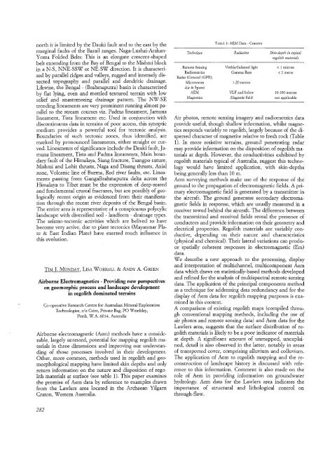
Technique<br />
Remote Sensing<br />
Radiometries<br />
Radar (Ground (GPR);<br />
Microwaves<br />
Air & Space)<br />
AEM<br />
Magnetics<br />
TABLE 1: AEM Data - Content<br />
Radiation<br />
VisiblelInfrared light<br />
Gamma Rays<br />
1-20 metres<br />
VLF and below<br />
Magnetie field<br />
Skin-depthin typical<br />
regolith materials<br />
< 1 micron<br />
< 1 metre<br />
10-100 metres<br />
not applicable<br />
Air photos, remote sensing imagery and radiometries data<br />
provide useful, though shallow information, whilst magnetics<br />
responds variably to regolith, largely because of the dispersed<br />
character of magnetite relative to fresh rock (Table<br />
1). In more resistive terrains, ground penetrating radar<br />
may provide information on the disposition of regolith materials<br />
at depth. However, the conductivities exhibited by<br />
regolith materials typical of Australia, suggest this technology<br />
would have limited application, with skin-depths<br />
being generally less than 10 m.<br />
Aem surveying methods make use of the response of the<br />
ground to the propagation of electromagnetic fields. A primary<br />
electromagnetic field is generated by a transmitter in<br />
the aircraft. The ground generates secondary electromagnetic<br />
fields in response, which are usually measured in a<br />
receiver towed behind the aircraft. The difference between<br />
the transmitted and received fields reveal the presence of<br />
conductors and provide information on their geometry and<br />
electrical properties. Regolith materials are variably conductive,<br />
depending on their nature and characteristics<br />
(physical and chemical). Their lateral variations can produce<br />
spatially coherent responses in electromagnetic (Em)<br />
data.<br />
We describe a new approach to the processing, display<br />
and interpretation of multichannel, multicomponent Aem<br />
data which draws on statistically-based methods developed<br />
and refined for the analysis of multispectral remote sensing<br />
data. The application of the principal components method<br />
as a technique for addressing data redundancy and for the<br />
display of Aem data for regolith mapping purposes is examined<br />
in this context.<br />
A comparison of existing regolith maps (compiled through<br />
conventional mapping methods, including the use of<br />
air photos and remote sensing data) and Aem data for the<br />
Lawlers area, suggests that the surface distribution of regolith<br />
materials is likely to be a poor indicator of materials<br />
at depth. A significant amount of unmapped, unexplained,<br />
detail is also observed in the latter, notably in areas<br />
of transported cover, comprising alluvium and colluvium.<br />
The application of Aem to regolith mapping and the reconstruction<br />
of landscape history is discussed with reference<br />
to this information. Comment is also made on the<br />
role of Aem in providing information on groundwater<br />
hydrology. Aem data for the Lawlers area indicates the<br />
importance of structural and lithological control on<br />
through-flow.


