

PostGIS Raster : Extending PostgreSQL for The Support of ... - CoDE
PostGIS Raster : Extending PostgreSQL for The Support of ... - CoDE
PostGIS Raster : Extending PostgreSQL for The Support of ... - CoDE

You also want an ePaper? Increase the reach of your titles
YUMPU automatically turns print PDFs into web optimized ePapers that Google loves.
geological exploration and petroleum geology, computerized geo stratum simulation, synthetic<br />
mineral prediction, and 3-D oil field characterization, all <strong>of</strong> which involve raster data, are widely<br />
used.<br />
Geologists use a number <strong>of</strong> field, laboratory, and numerical modeling methods to decipher Earth<br />
history and understand the processes that occur on and in the Earth. In typical geological<br />
investigations, geologists use primary in<strong>for</strong>mation related to petrology (the study <strong>of</strong> rocks),<br />
stratigraphy (the study <strong>of</strong> sedimentary layers), and structural geology (the study <strong>of</strong> positions<br />
<strong>of</strong> rock units and their de<strong>for</strong>mation). In many cases, geologists also study modern soils, rivers,<br />
landscapes, and glaciers; investigate past and current life and biogeochemical pathways, and use<br />
geophysical methods to investigate the subsurface.<br />
In modern times, geology is commercially important <strong>for</strong> mineral and hydrocarbon exploration<br />
and <strong>for</strong> evaluating water resources; is publicly important <strong>for</strong> the prediction and understanding<br />
<strong>of</strong> natural hazards, the remediation <strong>of</strong> environmental problems, and <strong>for</strong> providing insights into<br />
past climate change; plays a role in geotechnical engineering; and is a major academic discipline.<br />
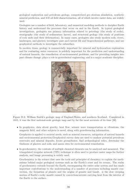
Figure D.3: William Smith’s geologic map <strong>of</strong> England,Wales, and southern Scotland. Completed in<br />
1815, it was the first national-scale geologic map and by far the most accurate <strong>of</strong> its time [39].<br />
• In geophysics, data about gravity, heat flow, seismic wave transportation or vibrations, the<br />
magnetic field, and other subjects is saved, along with georeferencing in<strong>for</strong>mation.<br />
Geophysics is applied to societal needs, such as mineral resources, mitigation <strong>of</strong> natural hazards<br />
and environmental protection.Geophysical survey data are used to analyze potential petroleum<br />
reservoirs and mineral deposits, locate groundwater, find archaeological relics, determine the<br />
thickness <strong>of</strong> glaciers and soils, and assess sites <strong>for</strong> environmental remediation.<br />
• In geochemistry, the contents <strong>of</strong> multiple chemical elements can be analyzed and measured. <strong>The</strong><br />
triangulated irregular network (TIN) technique is <strong>of</strong>ten used to produce raster maps <strong>for</strong> further<br />
analysis, and image processing is widely used.<br />
Geochemistry is the science that uses the tools and principles <strong>of</strong> chemistry to explain the mechanisms<br />
behind major geological systems such as the Earth’s crust and its oceans. <strong>The</strong> realm<br />
<strong>of</strong> geochemistry extends beyond the Earth, encompassing the entire solar system and has made<br />
important contributions to the understanding <strong>of</strong> a number <strong>of</strong> processes including mantle convection,<br />
the <strong>for</strong>mation <strong>of</strong> planets and the origins <strong>of</strong> granite and basalt. is the slow creeping<br />
motion <strong>of</strong> Earth’s rocky mantle caused by convectioncurrents carrying heat from the interior <strong>of</strong><br />
the Earth to the surface.<br />
99


