

PostGIS Raster : Extending PostgreSQL for The Support of ... - CoDE
PostGIS Raster : Extending PostgreSQL for The Support of ... - CoDE
PostGIS Raster : Extending PostgreSQL for The Support of ... - CoDE

Create successful ePaper yourself
Turn your PDF publications into a flip-book with our unique Google optimized e-Paper software.
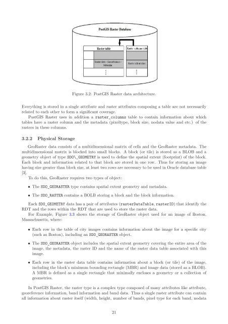
Figure 3.2: <strong>PostGIS</strong> <strong>Raster</strong> data architecture.<br />
Everything is stored in a single attribute and raster attributes composing a table are not necessarily<br />
related to each other to <strong>for</strong>m a significant coverage.<br />
<strong>PostGIS</strong> <strong>Raster</strong> uses in addition a raster_columns table to contain in<strong>for</strong>mation about which<br />
tables have a raster column and the metadata (pixeltype, block size, nodata value and etc.) <strong>of</strong> the<br />
rasters in these columns.<br />
3.2.2 Physical Storage<br />
Geo<strong>Raster</strong> data consists <strong>of</strong> a multidimensional matrix <strong>of</strong> cells and the Geo<strong>Raster</strong> metadata. <strong>The</strong><br />
multidimensional matrix is blocked into small blocks. A block (or tile) is stored as a BLOB and a<br />
geometry object <strong>of</strong> type SDO\_GEOMETRY is used to define the spatial extent (footprint) <strong>of</strong> the block.<br />
Each block and in<strong>for</strong>mation related to that block are stored in one row. Thus <strong>for</strong> storing an image<br />
having size greater than block size, at least two rows are necessary to be used in Oracle database table<br />
[3].<br />
To do this, Geo<strong>Raster</strong> requires two types <strong>of</strong> object:<br />
• <strong>The</strong> SDO_GEORASTER type contains spatial extent geometry and metadata.<br />
• <strong>The</strong> SDO_RASTER contains a BOLB storing a block and the block in<strong>for</strong>mation.<br />
Each SDO_GEOMETRY data has a pair <strong>of</strong> attributes (rasterDataTable, rasterID) that identify the<br />
RDT and the rows within the RDT that are used to store the raster data.<br />
For Example, Figure 3.3 shows the storage <strong>of</strong> Geo<strong>Raster</strong> object used <strong>for</strong> an image <strong>of</strong> Boston,<br />
Massachusetts, where:<br />
• Each row in the table <strong>of</strong> city images contains in<strong>for</strong>mation about the image <strong>for</strong> a specific city<br />
(such as Boston), including an SDO_GEORASTER object.<br />
• <strong>The</strong> SDO_GEORASTER object includes the spatial extent geometry covering the entire area <strong>of</strong> the<br />
image, the metadata, the raster ID and the name <strong>of</strong> the raster data table associated with this<br />
image.<br />
• Each row in the raster data table contains in<strong>for</strong>mation about a block (or tile) <strong>of</strong> the image,<br />
including the block’s minimum bounding rectangle (MBR) and image data (stored as a BLOB).<br />
A MBR is defined as a single rectangle that minimally encloses a geometry or a collection <strong>of</strong><br />
geometries.<br />
In <strong>PostGIS</strong> <strong>Raster</strong>, the raster type is a complex type composed <strong>of</strong> many attributes like attribute,<br />
georeference in<strong>for</strong>mation, band in<strong>for</strong>mation and band data. Thus a single raster attribute can contain<br />
all in<strong>for</strong>mation about raster itself (width, height, number <strong>of</strong> bands, pixel type <strong>for</strong> each band, nodata<br />
21


