

PostGIS Raster : Extending PostgreSQL for The Support of ... - CoDE
PostGIS Raster : Extending PostgreSQL for The Support of ... - CoDE
PostGIS Raster : Extending PostgreSQL for The Support of ... - CoDE

Create successful ePaper yourself
Turn your PDF publications into a flip-book with our unique Google optimized e-Paper software.
2.6 GIS Applications<br />
2.6.1 Crime Mapping<br />
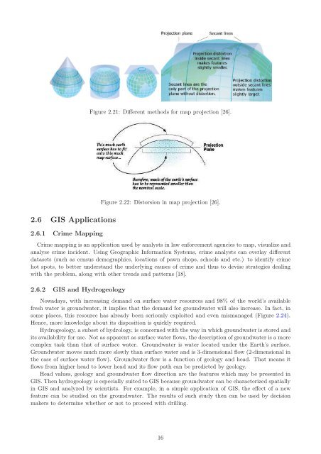
Figure 2.21: Different methods <strong>for</strong> map projection [26].<br />
Figure 2.22: Distorsion in map projection [26].<br />
Crime mapping is an application used by analysts in law en<strong>for</strong>cement agencies to map, visualize and<br />
analyse crime incident. Using Geographic In<strong>for</strong>mation Systems, crime analysts can overlay different<br />
datasets (such as census demographics, locations <strong>of</strong> pawn shops, schools and etc.) to identify crime<br />
hot spots, to better understand the underlying causes <strong>of</strong> crime and thus to devise strategies dealing<br />
with the problem, along with other trends and patterns [18].<br />
2.6.2 GIS and Hydrogeology<br />
Nowadays, with increasing demand on surface water resources and 98% <strong>of</strong> the world’s available<br />
fresh water is groundwater, it implies that the demand <strong>for</strong> groundwater will also increase. In fact, in<br />
some places, this resource has already been seriously exploited and even mismanaged (Figure 2.24).<br />
Hence, more knowledge about its disposition is quickly required.<br />
Hydrogeology, a subset <strong>of</strong> hydrology, is concerned with the way in which groundwater is stored and<br />
its availability <strong>for</strong> use. Not as apparent as surface water flows, the description <strong>of</strong> groundwater is a more<br />
complex task than that <strong>of</strong> surface water. Groundwater is water located under the Earth’s surface.<br />
Groundwater moves much more slowly than surface water and is 3-dimensional flow (2-dimensional in<br />
the case <strong>of</strong> surface water flow). Groundwater flow is a function <strong>of</strong> geology and head. That means it<br />
flows from higher head to lower head and its flow path can be predicted by geology.<br />
Head values, geology and groundwater flow direction are the features which may be presented in<br />
GIS. <strong>The</strong>n hydrogeology is especially suited to GIS because groundwater can be characterized spatially<br />
in GIS and analyzed by scientists. For example, in a simple application <strong>of</strong> GIS, the effect <strong>of</strong> a new<br />
feature can be studied on the groundwater. <strong>The</strong> results <strong>of</strong> such study then can be used by decision<br />
makers to determine whether or not to proceed with drilling.<br />
16


