

PostGIS Raster : Extending PostgreSQL for The Support of ... - CoDE
PostGIS Raster : Extending PostgreSQL for The Support of ... - CoDE
PostGIS Raster : Extending PostgreSQL for The Support of ... - CoDE

You also want an ePaper? Increase the reach of your titles
YUMPU automatically turns print PDFs into web optimized ePapers that Google loves.
4.4.4 Representing Features<br />
Figure 4.13: <strong>Raster</strong> zones and regions [32].<br />
In raster data, the cell typically represents the predominant phenomenon <strong>of</strong> the area covered by<br />
a cell, whereas vector data can accurately identify individual features. This is due to the fact that<br />
when representing geographic features using raster data, features are nothing more than collections<br />
<strong>of</strong> cells with the same attribute values and thus lose their unique identities. <strong>Raster</strong> data is best used<br />
when the primary problem concerns with the locational relationships <strong>of</strong> the phenomena represented<br />
by geographic features and not the features themselves.<br />
Discrete Data<br />
Discrete data, which is sometimes called thematic, categorical or discontinuous data, is used to<br />
describe discrete objects and can be expressed in both vector and raster <strong>for</strong>mats. A discrete object has<br />
always precise boundaries. So it is easy to define where the object begins and where it ends as well as<br />
how to compose them from discrete features like points, lines and polygons. A lake is a discrete object<br />
surrounded by landscape. Other examples <strong>of</strong> discrete objects include buildings, roads and parcels.<br />
Points<br />
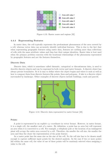
Figure 4.14: Discrete data represented in raster <strong>for</strong>mat [33].<br />
A point is represented by an explicit x,y coordinate in vector <strong>for</strong>mat. However, in raster <strong>for</strong>mat,<br />
it is a single cell, the smallest unit <strong>of</strong> a raster. By definition, a point has no area but will represent<br />
an area when it is converted to a cell. For example, a telephone pole or the location <strong>of</strong> an endangered<br />
plant will occupy the entire area covered by a cell. <strong>The</strong>re<strong>for</strong>e, the smaller the cell size, the smaller the<br />
area and thus the closer the representation <strong>of</strong> the point feature.<br />
As a raster point has the same size as the size <strong>of</strong> the cell. So the cell size has to be chosen small<br />
enough to capture sufficient input points <strong>for</strong> the desired analysis. In the case if two or more points<br />
fall within the same cell, the value <strong>of</strong> one <strong>of</strong> these points will be randomly selected when assigning a<br />
value to the cell.<br />
35


