

PostGIS Raster : Extending PostgreSQL for The Support of ... - CoDE
PostGIS Raster : Extending PostgreSQL for The Support of ... - CoDE
PostGIS Raster : Extending PostgreSQL for The Support of ... - CoDE

You also want an ePaper? Increase the reach of your titles
YUMPU automatically turns print PDFs into web optimized ePapers that Google loves.
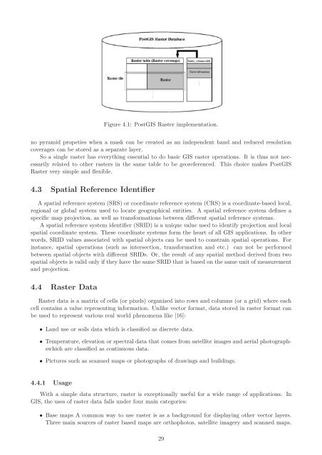
Figure 4.1: <strong>PostGIS</strong> <strong>Raster</strong> implementation.<br />
no pyramid propeties when a mask can be created as an independent band and reduced resolution<br />
coverages can be stored as a separate layer.<br />
So a single raster has everything essential to do basic GIS raster operations. It is thus not necessarily<br />
related to other rasters in the same table to be georeferenced. This choice makes <strong>PostGIS</strong><br />
<strong>Raster</strong> very simple and flexible.<br />
4.3 Spatial Reference Identifier<br />
A spatial reference system (SRS) or coordinate reference system (CRS) is a coordinate-based local,<br />
regional or global system used to locate geographical entities. A spatial reference system defines a<br />
specific map projection, as well as trans<strong>for</strong>mations between different spatial reference systems.<br />
A spatial reference system identifier (SRID) is a unique value used to identify projection and local<br />
spatial coordinate system. <strong>The</strong>se coordinate systems <strong>for</strong>m the heart <strong>of</strong> all GIS applications. In other<br />
words, SRID values associated with spatial objects can be used to constrain spatial operations. For<br />
instance, spatial operations (such as intersection, trans<strong>for</strong>mation and etc.) can not be per<strong>for</strong>med<br />
between spatial objects with different SRIDs. Or, the result <strong>of</strong> any spatial method derived from two<br />
spatial objects is valid only if they have the same SRID that is based on the same unit <strong>of</strong> measurement<br />
and projection.<br />
4.4 <strong>Raster</strong> Data<br />
<strong>Raster</strong> data is a matrix <strong>of</strong> cells (or pixels) organized into rows and columns (or a grid) where each<br />
cell contains a value representing in<strong>for</strong>mation. Unlike vector <strong>for</strong>mat, data stored in raster <strong>for</strong>mat can<br />
be used to represent various real world phenomena like [16]:<br />
• Land use or soils data which is classified as discrete data.<br />
• Temperature, elevation or spectral data that comes from satellite images and aerial photographswhich<br />
are classified as continuous data.<br />
• Pictures such as scanned maps or photographs <strong>of</strong> drawings and buildings.<br />
4.4.1 Usage<br />
With a simple data structure, raster is exceptionally useful <strong>for</strong> a wide range <strong>of</strong> applications. In<br />
GIS, the uses <strong>of</strong> raster data falls under four main categories:<br />
• Base maps A common way to use raster is as a background <strong>for</strong> displaying other vector layers.<br />
Three main sources <strong>of</strong> raster based maps are orthophotos, satellite imagery and scanned maps.<br />
29


