

PostGIS Raster : Extending PostgreSQL for The Support of ... - CoDE
PostGIS Raster : Extending PostgreSQL for The Support of ... - CoDE
PostGIS Raster : Extending PostgreSQL for The Support of ... - CoDE

Create successful ePaper yourself
Turn your PDF publications into a flip-book with our unique Google optimized e-Paper software.
within and between layers.<br />
• GIS layers can be combined from many sources and many users. In fact, most users are dependent<br />
on one another <strong>for</strong> portions <strong>of</strong> the data they want to use. So interoperability becomes a<br />
fundamental feature in GIS.<br />
2.5 Georeference and Coordinate Systems<br />
2.5.1 Georeference<br />
All elements in a map have a specific geographic location and extent that enable them to be<br />
located on the Earth’s surface. So to georeference something means to describe its existence on the<br />
Earth’s surface. <strong>The</strong> term is used when establishing the relation between raster or vector images and<br />
coordinates or when determining the spatial location <strong>of</strong> other geographical features. Examples would<br />
include establishing the correct position <strong>of</strong> an aerial photograph within a map or finding the geographical<br />
coordinates <strong>of</strong> street address. <strong>The</strong> georeferencing procedure is thus imperative <strong>for</strong> modeling<br />
geographical data in the field <strong>of</strong> geographic in<strong>for</strong>mation systems.<br />
2.5.2 What Is a Coordinate System?<br />
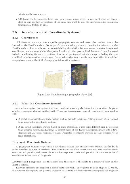
Figure 2.16: Georeferencing a geographic object [26].<br />
A coordinate system is a system that uses coordinates to uniquely determine the location <strong>of</strong> a point<br />
or other geographic element on the Earth. <strong>The</strong>re are two common types <strong>of</strong> coordinate system used in<br />
GIS:<br />
• A global or spherical coordinate system such as latitude-longitude. This system is <strong>of</strong>ten referred<br />
to as geographic coordinate system.<br />
• A projected coordinate system based on map projection. <strong>The</strong>re exist different map projections<br />
that provides various mechanisms to project maps <strong>of</strong> the Earth’s spherical surface onto a twodimensional<br />
Cartesian coordinate plane. Projected coordinate systems are also referred to as<br />
map projections.<br />
Geographic Coordinate Systems<br />
A geographic coordinate system is a coordinate system that enables every location on the Earth<br />
to be specified by a set <strong>of</strong> numbers. <strong>The</strong> coordinates are <strong>of</strong>ten chosen such that one number represents<br />
vertical position and two or three numbers represent horizontal position. A common choice <strong>of</strong><br />
coordinates is latitude and longitude.<br />
Latitude and Longitude are the angles from the center <strong>of</strong> the Earth to a measured point on the<br />
Earth’s surface.<br />
Latitude measures are angles in a north-south direction. <strong>The</strong> equator is at an angle <strong>of</strong> 0. Often,<br />
the northern hemisphere has positive measures <strong>of</strong> latitude and the southern hemisphere has negative<br />
13


