geological exploration and petroleum geology, computerized geo stratum simulation, synthetic mineral prediction, and 3-D oil field characterization, all <strong>of</strong> which involve raster data, are widely used. Geologists use a number <strong>of</strong> field, laboratory, and numerical modeling methods to decipher Earth history and understand the processes that occur on and in the Earth. In typical geological investigations, geologists use primary in<strong>for</strong>mation related to petrology (the study <strong>of</strong> rocks), stratigraphy (the study <strong>of</strong> sedimentary layers), and structural geology (the study <strong>of</strong> positions <strong>of</strong> rock units and their de<strong>for</strong>mation). In many cases, geologists also study modern soils, rivers, landscapes, and glaciers; investigate past and current life and biogeochemical pathways, and use geophysical methods to investigate the subsurface. In modern times, geology is commercially important <strong>for</strong> mineral and hydrocarbon exploration and <strong>for</strong> evaluating water resources; is publicly important <strong>for</strong> the prediction and understanding <strong>of</strong> natural hazards, the remediation <strong>of</strong> environmental problems, and <strong>for</strong> providing insights into past climate change; plays a role in geotechnical engineering; and is a major academic discipline. Figure D.3: William Smith’s geologic map <strong>of</strong> England,Wales, and southern Scotland. Completed in 1815, it was the first national-scale geologic map and by far the most accurate <strong>of</strong> its time [39]. • In geophysics, data about gravity, heat flow, seismic wave transportation or vibrations, the magnetic field, and other subjects is saved, along with georeferencing in<strong>for</strong>mation. Geophysics is applied to societal needs, such as mineral resources, mitigation <strong>of</strong> natural hazards and environmental protection.Geophysical survey data are used to analyze potential petroleum reservoirs and mineral deposits, locate groundwater, find archaeological relics, determine the thickness <strong>of</strong> glaciers and soils, and assess sites <strong>for</strong> environmental remediation. • In geochemistry, the contents <strong>of</strong> multiple chemical elements can be analyzed and measured. <strong>The</strong> triangulated irregular network (TIN) technique is <strong>of</strong>ten used to produce raster maps <strong>for</strong> further analysis, and image processing is widely used. Geochemistry is the science that uses the tools and principles <strong>of</strong> chemistry to explain the mechanisms behind major geological systems such as the Earth’s crust and its oceans. <strong>The</strong> realm <strong>of</strong> geochemistry extends beyond the Earth, encompassing the entire solar system and has made important contributions to the understanding <strong>of</strong> a number <strong>of</strong> processes including mantle convection, the <strong>for</strong>mation <strong>of</strong> planets and the origins <strong>of</strong> granite and basalt. is the slow creeping motion <strong>of</strong> Earth’s rocky mantle caused by convectioncurrents carrying heat from the interior <strong>of</strong> the Earth to the surface. 99
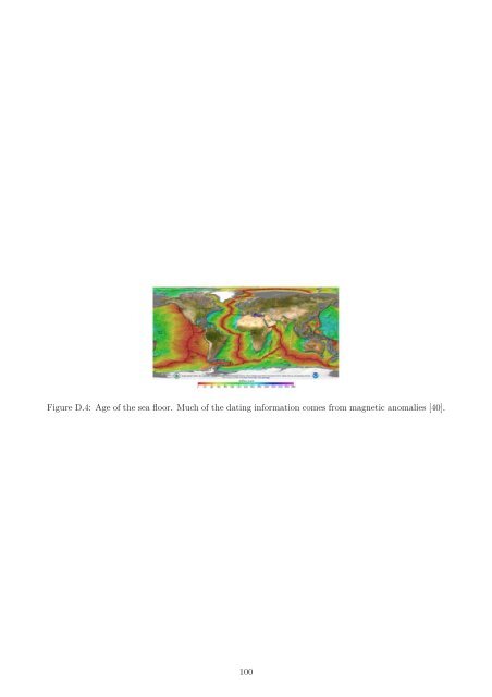
Figure D.4: Age <strong>of</strong> the sea floor. Much <strong>of</strong> the dating in<strong>for</strong>mation comes from magnetic anomalies [40]. 100