

PostGIS Raster : Extending PostgreSQL for The Support of ... - CoDE
PostGIS Raster : Extending PostgreSQL for The Support of ... - CoDE
PostGIS Raster : Extending PostgreSQL for The Support of ... - CoDE

You also want an ePaper? Increase the reach of your titles
YUMPU automatically turns print PDFs into web optimized ePapers that Google loves.
impossible to reproduce the original colors. To get around this, scanners use a process called dithering<br />
to approximate colors that don’t occur in the current color palette.<br />
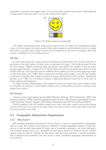
Figure 2.13: <strong>Raster</strong> image in zooming [28].<br />
<strong>The</strong> biggest disadvantage when using raster images locates at editing and manipulating image<br />
colors. As vector images are object-oriented while raster images are pixel oriented, in order to change<br />
pixel colors, a specific color or range <strong>of</strong> colors must be isolated from the rest to be changed. This work<br />
is quite a challenge <strong>for</strong> even experienced users.<br />
File Size<br />
For each raster image file, a large amount <strong>of</strong> in<strong>for</strong>mation, including the exact location and color <strong>of</strong><br />
each pixel in the grid, needs to be kept track to reproduce the image. This results in large file sizes<br />
<strong>for</strong> raster images. Higher resolutions (dpi) and greater color depths (the number <strong>of</strong> bits per pixel)<br />
produce bigger file sizes. A typical 2" by 3" 150 dpi black and white raster image logo will be less than<br />
70 KB in file size. <strong>The</strong> same file saved as a 300 dpi 24-bit (millions <strong>of</strong> colors) raster image logo might<br />
be 100 times larger (over 7 MB). When creating and scanning raster images, raster file size becomes<br />
a real issue, as big files tend to make computer processor and hard drive work overtime. Transferring<br />
big files (over 1 MB) over the Internet requires a high speed Internet connection on both ends <strong>for</strong><br />
timely uploads and downloads.<br />
In despite <strong>of</strong> these disadvantages, raster images are more practically than vector images as they<br />
are viewable via monitors or other display medium and it is impossible in practice to obtain vector<br />
images from a photo.<br />
File Formats<br />
Common raster image <strong>for</strong>mats include BMP (Windows Bitmap), PCX (Paintbrush), TIFF (Tag<br />
Interleave Format), JPEG (Joint Photographics Expert Group), GIF (Graphics Interchange Format)<br />
, PNG (Portable Network Graphic), PSD (Adobe PhotoShop) and CPT (Corel Photo PAINT).<br />
Perfect graphical tools will combine images from vector and raster sources and provide editing<br />
tools <strong>for</strong> both, since some parts <strong>of</strong> an image could come from a camera source and others could have<br />
been drawn using vector tools.<br />
2.4 Geographic In<strong>for</strong>mation Organization<br />
2.4.1 Map Layers<br />
GIS organizes geographic in<strong>for</strong>mation in terms <strong>of</strong> layers. A layer is a representation <strong>of</strong> geographic<br />
data on a map. For example, vector layers are collections <strong>of</strong> simple geographic elements <strong>of</strong> same type<br />
such as a road network (represented by lines), parcel boundaries (polygons), soil types (polygons),<br />
well locations (points) and so on. Examples <strong>of</strong> raster layers include an elevation surface, satellite<br />
imagery, land use and etc. Within the data frame, each layer that represents a specific geographic<br />
data is displayed and overlaid by the other layers to <strong>for</strong>m a significant geographic representation in<br />
real world [5].<br />
11


