

PostGIS Raster : Extending PostgreSQL for The Support of ... - CoDE
PostGIS Raster : Extending PostgreSQL for The Support of ... - CoDE
PostGIS Raster : Extending PostgreSQL for The Support of ... - CoDE

Create successful ePaper yourself
Turn your PDF publications into a flip-book with our unique Google optimized e-Paper software.
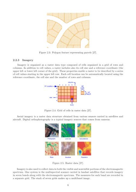
2.2.3 Imagery<br />
Figure 2.3: Polygon feature representing parcels [27].<br />
Imagery is organized as a raster data type composed <strong>of</strong> cells organized in a grid <strong>of</strong> rows and<br />
columns. In addition to cell values, a raster includes also its cell size and a reference coordinate (the<br />
upper left or lower left corner <strong>of</strong> the grid). <strong>The</strong>se properties enable a raster to be described by a series<br />
<strong>of</strong> cell values starting in the upper left row. Each cell location can be automatically located using the<br />
reference coordinate, the cell size and the number <strong>of</strong> rows and columns.<br />
Figure 2.4: Grid <strong>of</strong> cells in raster data [27].<br />
Aerial imagery is a raster data structure obtained from various sensors carried in satellites and<br />
aircraft. Digital orthophotography is a typical imagery sources that comes from cameras.<br />
Figure 2.5: <strong>Raster</strong> data [27].<br />
Imagery is also used to collect data in both the visible and nonvisible portions <strong>of</strong> the electromagnetic<br />
spectrum. One system is the multispectral scanner carried in landsat satellites that records imagery<br />
in seven bands along with the electromagnetic spectrum. <strong>The</strong> measures <strong>for</strong> each band are recorded in<br />
a separate grid. <strong>The</strong> stack <strong>of</strong> seven grids makes up a multiband image.<br />
6


