

PostGIS Raster : Extending PostgreSQL for The Support of ... - CoDE
PostGIS Raster : Extending PostgreSQL for The Support of ... - CoDE
PostGIS Raster : Extending PostgreSQL for The Support of ... - CoDE

Create successful ePaper yourself
Turn your PDF publications into a flip-book with our unique Google optimized e-Paper software.
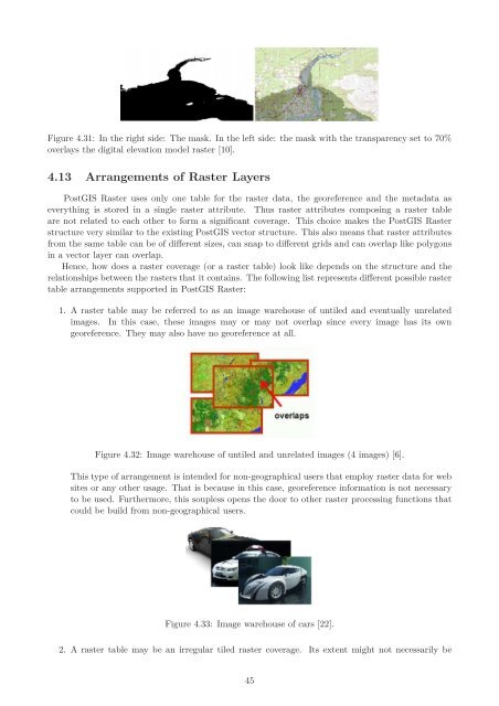
Figure 4.31: In the right side: <strong>The</strong> mask. In the left side: the mask with the transparency set to 70%<br />
overlays the digital elevation model raster [10].<br />
4.13 Arrangements <strong>of</strong> <strong>Raster</strong> Layers<br />
<strong>PostGIS</strong> <strong>Raster</strong> uses only one table <strong>for</strong> the raster data, the georeference and the metadata as<br />
everything is stored in a single raster attribute. Thus raster attributes composing a raster table<br />
are not related to each other to <strong>for</strong>m a significant coverage. This choice makes the <strong>PostGIS</strong> <strong>Raster</strong><br />
structure very similar to the existing <strong>PostGIS</strong> vector structure. This also means that raster attributes<br />
from the same table can be <strong>of</strong> different sizes, can snap to different grids and can overlap like polygons<br />
in a vector layer can overlap.<br />
Hence, how does a raster coverage (or a raster table) look like depends on the structure and the<br />
relationships between the rasters that it contains. <strong>The</strong> following list represents different possible raster<br />
table arrangements supported in <strong>PostGIS</strong> <strong>Raster</strong>:<br />
1. A raster table may be referred to as an image warehouse <strong>of</strong> untiled and eventually unrelated<br />
images. In this case, these images may or may not overlap since every image has its own<br />
georeference. <strong>The</strong>y may also have no georeference at all.<br />
Figure 4.32: Image warehouse <strong>of</strong> untiled and unrelated images (4 images) [6].<br />
This type <strong>of</strong> arrangement is intended <strong>for</strong> non-geographical users that employ raster data <strong>for</strong> web<br />
sites or any other usage. That is because in this case, georeference in<strong>for</strong>mation is not necessary<br />
to be used. Furthermore, this soupless opens the door to other raster processing functions that<br />
could be build from non-geographical users.<br />
Figure 4.33: Image warehouse <strong>of</strong> cars [22].<br />
2. A raster table may be an irregular tiled raster coverage. Its extent might not necessarily be<br />
45


