

PostGIS Raster : Extending PostgreSQL for The Support of ... - CoDE
PostGIS Raster : Extending PostgreSQL for The Support of ... - CoDE
PostGIS Raster : Extending PostgreSQL for The Support of ... - CoDE

Create successful ePaper yourself
Turn your PDF publications into a flip-book with our unique Google optimized e-Paper software.
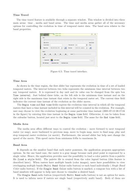
Time Travel<br />
<strong>The</strong> time travel feature is available through a separate window. This window is divided into three<br />
main areas: time , media and band areas. <strong>The</strong> time and media areas gather all <strong>of</strong> the necessary<br />
options <strong>for</strong> controlling the evolution in time <strong>of</strong> temporal raster data. <strong>The</strong> band area relates to the<br />
band properties.<br />
Time Area<br />
Figure 6.5: Time travel interface.<br />
As shown in the time region, the first slider bar represents the evolution in time <strong>of</strong> a set <strong>of</strong> loaded<br />
temporal rasters. <strong>The</strong> interval between two ticks represents the minimum time interval between two<br />
any temporal rasters. It is expressed in day unit and its value can be changed from the spin box<br />
Time interval. Just behind these ticks, on the left side is the minimum time instant and on the<br />
right side is the maximum time instant that exists in the temporal raster set. <strong>The</strong> current time field<br />
indicates the current time instant <strong>of</strong> the evolution as the slider moves.<br />
<strong>The</strong> Begin time and End time fields express the evolution time interval in which all the temporal<br />
rasters that have a time instant included in this interval will be counted in the evolution. For example,<br />
user may choose to view the evolution beginning at some particular time instant (2001-07-13 08:17:34<br />
in the figure) by entering this time instant in the Begin time field. Otherwise, it can be taken from<br />
the calendar button, located just next to the Begin time field. <strong>The</strong> same <strong>for</strong> the End time field.<br />
Media Area<br />
<strong>The</strong> media area <strong>of</strong>fers different ways to control the evolution : move <strong>for</strong>ward to next temporal<br />
raster (or map), move backward to previous map, move to begin map, move to final map, play and<br />
stop temporal raster evolution (or movie). Furthermore, the second slider bar help user change the<br />
speed <strong>of</strong> the movie. This speed varies from minimum 0.05s to maximum 2s.<br />
Band Area<br />
It depends on the number band that each raster possesses, the application proposes appropriate<br />
options. In the one band case, the raster is a gray image because each pixel point is expressed by a<br />
single value. Hence, the application provides user the possibility to load a color palette from a palette<br />
file (Load a style field). <strong>The</strong> palette file is created from the color legend button (this feature is<br />
described later). When rasters have multiple bands (color images), users have possibilities to view<br />
overlapping multiple bands (Multi Band Color radio button) or each band individually ( Single Band<br />
Color radio button). If the Single Band Color radio button is marked, a compose box with a list <strong>of</strong><br />
band numbers will appear to help user choose to visualize a desired band.<br />
<strong>The</strong> Single Band radio button (respectively Multi Band radio button) is not an option <strong>for</strong> users.<br />
It is used to in<strong>for</strong>m users if rasters are single band (respectively multi band). Both <strong>of</strong> them are<br />
75


