

PostGIS Raster : Extending PostgreSQL for The Support of ... - CoDE
PostGIS Raster : Extending PostgreSQL for The Support of ... - CoDE
PostGIS Raster : Extending PostgreSQL for The Support of ... - CoDE

You also want an ePaper? Increase the reach of your titles
YUMPU automatically turns print PDFs into web optimized ePapers that Google loves.
SELECT ST_AsJPEG(rast) As rastjpg<br />
FROM dummy_rast<br />
WHERE rid=1;<br />
5.6.3 <strong>Raster</strong> to PNG File<br />
<strong>The</strong> ST_AsPNG(raster, band/numberbands, compression) function returns the selected raster bands<br />
as a single PNG image (byte array). Where:<br />
– band: a number that specifies a band <strong>for</strong> single band export.<br />
– numberbands: an array <strong>of</strong> bands used to export. Bands are mapped to RGB or RGBA space.<br />
For example, ARRAY[3,2,1] means map band 3 to Red, band 2 to green and band 1 to blue.<br />
If both band and numberbands are not specified, then all bands are used if the raster has 1, 3, or<br />
4 bands and. If it has 2 or more than 4 bands, then only band 1 is used.<br />
– compression is a number from 1 to 9.<br />
SELECT ST_AsPNG(rast) As rastpng<br />
FROM dummy_rast WHERE rid=2;<br />
5.7 Intersect <strong>Raster</strong>s with Vectors<br />
One approach to make this operation is to convert all raster tiles to a set <strong>of</strong> geometries and do a<br />
traditional intersection query between geometries only. <strong>The</strong> problem is that vectorizing all the tiles<br />
will be too long and it is impossible to load a huge number <strong>of</strong> geometry in GIS s<strong>of</strong>tware. Since it is<br />
mostly impossible to convert those tiles to vectors, the <strong>PostGIS</strong> <strong>Raster</strong> approach will vectorize only<br />
what is needed to do the requested operation.<br />
In the intersection, if a geometry completely overlaps a nodata value area <strong>of</strong> one tile, st_intersects(rast,<br />
geom) will return false <strong>for</strong> this tile/geometry couple and st_intersection(rast, geom)<br />
will return an EMPTY GEOMETRY without vectoring this tile. If the geometry partially overlaps a nodata<br />
value area and intersects other parts <strong>of</strong> the tile, st_intersects(rast, geom) will return true <strong>for</strong> this<br />
tile/geometry couple and st_intersection(rast, geom) will return only values <strong>of</strong> parts <strong>of</strong> the tile<br />
that intersects the geometry.<br />
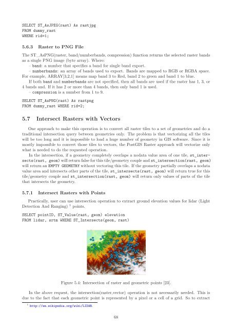
5.7.1 Intersect <strong>Raster</strong>s with Points<br />
Practically, user can use intersection operation to extract ground elevation values <strong>for</strong> lidar (Light<br />
Detection And Ranging) 1 points.<br />
SELECT pointID, ST_Value(rast, geom) elevation<br />
FROM lidar, srtm WHERE ST_Intersects(geom, rast)<br />
Figure 5.4: Intersection <strong>of</strong> raster and geometric points [23].<br />
In the above request, the intersection(raster,vector) operation is not necessarily needed. This is<br />
due to the fact that each geometric point is represented by a pixel or a cell <strong>of</strong> a grid. So to extract<br />
1 http://en.wikipedia.org/wiki/LIDAR.<br />
68


