

PostGIS Raster : Extending PostgreSQL for The Support of ... - CoDE
PostGIS Raster : Extending PostgreSQL for The Support of ... - CoDE
PostGIS Raster : Extending PostgreSQL for The Support of ... - CoDE

Create successful ePaper yourself
Turn your PDF publications into a flip-book with our unique Google optimized e-Paper software.
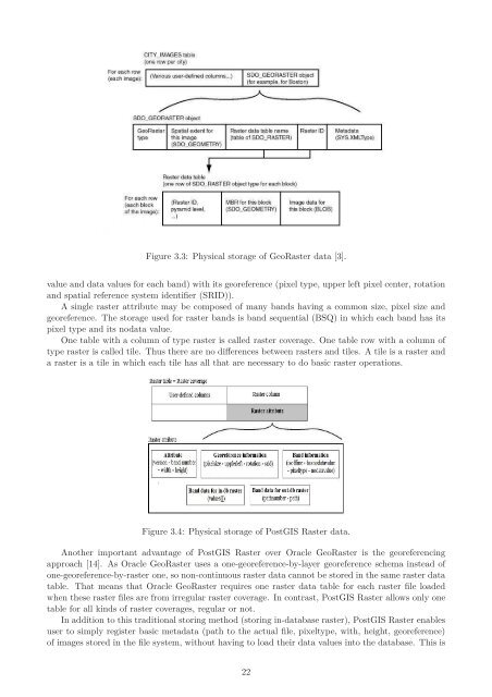
Figure 3.3: Physical storage <strong>of</strong> Geo<strong>Raster</strong> data [3].<br />
value and data values <strong>for</strong> each band) with its georeference (pixel type, upper left pixel center, rotation<br />
and spatial reference system identifier (SRID)).<br />
A single raster attribute may be composed <strong>of</strong> many bands having a common size, pixel size and<br />
georeference. <strong>The</strong> storage used <strong>for</strong> raster bands is band sequential (BSQ) in which each band has its<br />
pixel type and its nodata value.<br />
One table with a column <strong>of</strong> type raster is called raster coverage. One table row with a column <strong>of</strong><br />
type raster is called tile. Thus there are no differences between rasters and tiles. A tile is a raster and<br />
a raster is a tile in which each tile has all that are necessary to do basic raster operations.<br />
Figure 3.4: Physical storage <strong>of</strong> <strong>PostGIS</strong> <strong>Raster</strong> data.<br />
Another important advantage <strong>of</strong> <strong>PostGIS</strong> <strong>Raster</strong> over Oracle Geo<strong>Raster</strong> is the georeferencing<br />
approach [14]. As Oracle Geo<strong>Raster</strong> uses a one-georeference-by-layer georeference schema instead <strong>of</strong><br />
one-georeference-by-raster one, so non-continuous raster data cannot be stored in the same raster data<br />
table. That means that Oracle Geo<strong>Raster</strong> requires one raster data table <strong>for</strong> each raster file loaded<br />
when these raster files are from irregular raster coverage. In contrast, <strong>PostGIS</strong> <strong>Raster</strong> allows only one<br />
table <strong>for</strong> all kinds <strong>of</strong> raster coverages, regular or not.<br />
In addition to this traditional storing method (storing in-database raster), <strong>PostGIS</strong> <strong>Raster</strong> enables<br />
user to simply register basic metadata (path to the actual file, pixeltype, with, height, georeference)<br />
<strong>of</strong> images stored in the file system, without having to load their data values into the database. This is<br />
22


