

PostGIS Raster : Extending PostgreSQL for The Support of ... - CoDE
PostGIS Raster : Extending PostgreSQL for The Support of ... - CoDE
PostGIS Raster : Extending PostgreSQL for The Support of ... - CoDE

You also want an ePaper? Increase the reach of your titles
YUMPU automatically turns print PDFs into web optimized ePapers that Google loves.
Appendix E<br />
<strong>Raster</strong> Resolution<br />
When working with raster data, there are four types <strong>of</strong> resolution <strong>of</strong>ten encountered: spatial<br />
resolution, spectral resolution, temporal resolution and radiometric resolution.<br />
Spatial resolution refers to the size <strong>of</strong> the smallest object that can be resolved on the ground. In a<br />
digital image, the resolution is limited by the pixel size, i.e. the smallest resolvable object cannot be<br />
smaller than the pixel size.<br />
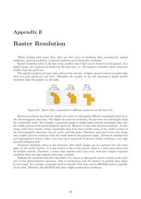
<strong>The</strong> spatial resolution <strong>of</strong> raster data refers to the cell size. A higher spatial resolution implies that<br />
there are more pixels per unit area. <strong>The</strong>re<strong>for</strong>e, the graphic on the left represents a higher spatial<br />
resolution than the graphic on the right.<br />
Figure E.1: <strong>Raster</strong> data represented at different resolution or cell sizes [11].<br />
Spectral resolution describes the ability <strong>of</strong> a sensor to distinguish different wavelength intervals in<br />
the electromagnetic spectrum. <strong>The</strong> higher the spectral resolution, the narrower the wavelength range<br />
<strong>for</strong> a particular band. For example, a grayscale image (a single band) records wavelength data over<br />
the visible portion <strong>of</strong> the electromagnetic spectrum. However, it has a low spectral resolution. A color<br />
image (with three bands) collects wavelength data from three smaller parts <strong>of</strong> the visible portion <strong>of</strong><br />
the electromagnetic spectrum: the red, green, and blue parts. <strong>The</strong>re<strong>for</strong>e, each band in the color image<br />
has a higher spectral resolution than the single band in the grayscale image. Advanced multispectral<br />
and hyperspectral sensors collect data from up to hundreds <strong>of</strong> spectral bands, resulting a very high<br />
spectral resolution data.<br />
Temporal resolution refers to the frequency with which images can be captured over the same<br />
place on the earth’s surface. It is also known as the revisit period, which is a term most <strong>of</strong>ten used<br />
<strong>for</strong> satellite sensors. <strong>The</strong>re<strong>for</strong>e, a sensor that captures data once every week has a higher temporal<br />
resolution than one that captures data once a month.<br />
Radiometric resolution describes the ability <strong>of</strong> a sensor to distinguish objects viewed in the same<br />
part <strong>of</strong> the electromagnetic spectrum. This is synonymous with the number <strong>of</strong> possible data values<br />
in each band. For example, a Landsat band is typically 8-bit data and an IKONOS band is typically<br />
11-bit data. <strong>The</strong>re<strong>for</strong>e, the IKONOS data has a higher radiometric resolution.<br />
101


