

PostGIS Raster : Extending PostgreSQL for The Support of ... - CoDE
PostGIS Raster : Extending PostgreSQL for The Support of ... - CoDE
PostGIS Raster : Extending PostgreSQL for The Support of ... - CoDE

You also want an ePaper? Increase the reach of your titles
YUMPU automatically turns print PDFs into web optimized ePapers that Google loves.
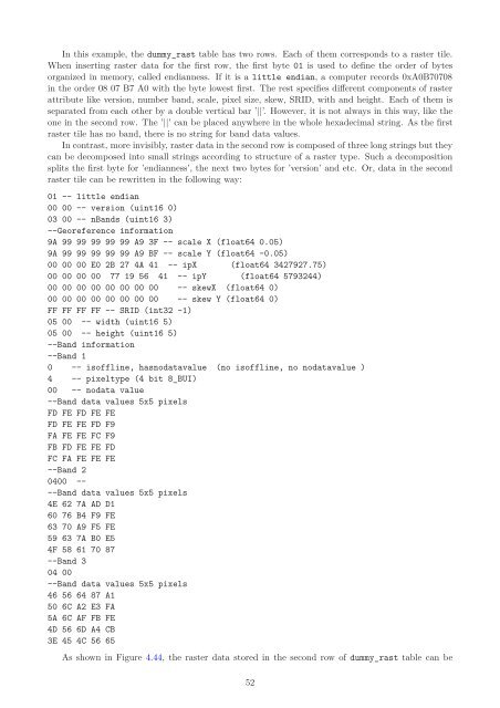
In this example, the dummy_rast table has two rows. Each <strong>of</strong> them corresponds to a raster tile.<br />
When inserting raster data <strong>for</strong> the first row, the first byte 01 is used to define the order <strong>of</strong> bytes<br />
organized in memory, called endianness. If it is a little endian, a computer records 0xA0B70708<br />
in the order 08 07 B7 A0 with the byte lowest first. <strong>The</strong> rest specifies different components <strong>of</strong> raster<br />
attribute like version, number band, scale, pixel size, skew, SRID, with and height. Each <strong>of</strong> them is<br />
separated from each other by a double vertical bar ’||’. However, it is not always in this way, like the<br />
one in the second row. <strong>The</strong> ’||’ can be placed anywhere in the whole hexadecimal string. As the first<br />
raster tile has no band, there is no string <strong>for</strong> band data values.<br />
In contrast, more invisibly, raster data in the second row is composed <strong>of</strong> three long strings but they<br />
can be decomposed into small strings according to structure <strong>of</strong> a raster type. Such a decomposition<br />
splits the first byte <strong>for</strong> ’endianness’, the next two bytes <strong>for</strong> ’version’ and etc. Or, data in the second<br />
raster tile can be rewritten in the following way:<br />
01 -- little endian<br />
00 00 -- version (uint16 0)<br />
03 00 -- nBands (uint16 3)<br />
--Georeference in<strong>for</strong>mation<br />
9A 99 99 99 99 99 A9 3F -- scale X (float64 0.05)<br />
9A 99 99 99 99 99 A9 BF -- scale Y (float64 -0.05)<br />
00 00 00 E0 2B 27 4A 41 -- ipX (float64 3427927.75)<br />
00 00 00 00 77 19 56 41 -- ipY (float64 5793244)<br />
00 00 00 00 00 00 00 00 -- skewX (float64 0)<br />
00 00 00 00 00 00 00 00 -- skew Y (float64 0)<br />
FF FF FF FF -- SRID (int32 -1)<br />
05 00 -- width (uint16 5)<br />
05 00 -- height (uint16 5)<br />
--Band in<strong>for</strong>mation<br />
--Band 1<br />
0 -- is<strong>of</strong>fline, hasnodatavalue (no is<strong>of</strong>fline, no nodatavalue )<br />
4 -- pixeltype (4 bit 8_BUI)<br />
00 -- nodata value<br />
--Band data values 5x5 pixels<br />
FD FE FD FE FE<br />
FD FE FE FD F9<br />
FA FE FE FC F9<br />
FB FD FE FE FD<br />
FC FA FE FE FE<br />
--Band 2<br />
0400 --<br />
--Band data values 5x5 pixels<br />
4E 62 7A AD D1<br />
60 76 B4 F9 FE<br />
63 70 A9 F5 FE<br />
59 63 7A B0 E5<br />
4F 58 61 70 87<br />
--Band 3<br />
04 00<br />
--Band data values 5x5 pixels<br />
46 56 64 87 A1<br />
50 6C A2 E3 FA<br />
5A 6C AF FB FE<br />
4D 56 6D A4 CB<br />
3E 45 4C 56 65<br />
As shown in Figure 4.44, the raster data stored in the second row <strong>of</strong> dummy_rast table can be<br />
52


