

PostGIS Raster : Extending PostgreSQL for The Support of ... - CoDE
PostGIS Raster : Extending PostgreSQL for The Support of ... - CoDE
PostGIS Raster : Extending PostgreSQL for The Support of ... - CoDE

Create successful ePaper yourself
Turn your PDF publications into a flip-book with our unique Google optimized e-Paper software.
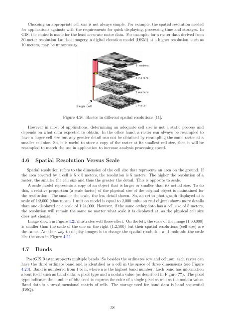
Choosing an appropriate cell size is not always simple. For example, the spatial resolution needed<br />
<strong>for</strong> applications againsts with the requirements <strong>for</strong> quick displaying, processing time and storages. In<br />
GIS, the choice is made <strong>for</strong> the least accurate raster data. For example, <strong>for</strong> a raster data derived from<br />
30-meter resolution Landsat imagery, a digital elevation model (DEM) at a higher resolution, such as<br />
10 meters, may be unnecessary.<br />
Figure 4.20: <strong>Raster</strong> in different spatial resolutions [11].<br />
However in most <strong>of</strong> applications, determining an adequate cell size is not a static process and<br />
depends on what data expected to obtain. In the other hand, a raster can always be resampled to<br />
have a larger cell size but any greater detail can not be obtained by resampling the same raster at a<br />
smaller cell size. So, it is useful to store a copy <strong>of</strong> the raster at its smallest cell size, then it will be<br />
resampled to match the use in application to increase analysis processing speed.<br />
4.6 Spatial Resolution Versus Scale<br />
Spatial resolution refers to the dimension <strong>of</strong> the cell size that represents an area on the ground. If<br />
the area covered by a cell is 5 x 5 meters, the resolution is 5 meters. <strong>The</strong> higher the resolution <strong>of</strong> a<br />
raster, the smaller the cell size and thus the greater the detail. This is opposite to scale.<br />
A scale model represents a copy <strong>of</strong> an object that is larger or smaller than its actual size. To do<br />
this, a relative proportion (a scale factor) <strong>of</strong> the physical size <strong>of</strong> the original object is maintained <strong>for</strong><br />
the restitution. <strong>The</strong> smaller the scale, the less detail shown. So, an ortho photograph displayed at a<br />
scale <strong>of</strong> 1:2,000 (that means 1 unit on model is equal to 2,000 units on real object) shows more details<br />
than one displayed at a scale <strong>of</strong> 1:24,000. However, if the same orthophoto has a cell size <strong>of</strong> 5 meters,<br />
the resolution will remain the same no matter what scale it is displayed at, as the physical cell size<br />
does not change.<br />
Image shown in Figure 4.21 illustrates well these effect. On the left, the scale <strong>of</strong> the image (1:50,000)<br />
is smaller than the scale <strong>of</strong> the one on the right (1:2,500) but their spatial resolutions (cell size) are<br />
the same. Another way to display images is to change the spatial resolution and maintain the scale<br />
like the ones in Figure 4.22.<br />
4.7 Bands<br />
<strong>PostGIS</strong> <strong>Raster</strong> supports multiple bands. So besides the ordinates row and column, each raster can<br />
have the third ordinate band and is identified as a cell in the space <strong>of</strong> three dimensions (see Figure<br />
4.23). Band is numbered from 1 to n, where n is the highest band number. Each band has in<strong>for</strong>mation<br />
about itself such as band data, a pixel type and a nodata value (as described in Figure ??). <strong>The</strong> pixel<br />
type indicates the number <strong>of</strong> bits used to express the color <strong>of</strong> a single pixel as well as the nodata value.<br />
Band data is a two-dimensional matrix <strong>of</strong> cells. <strong>The</strong> storage used <strong>for</strong> band data is band sequential<br />
(BSQ).<br />
38


