INDUSTRIAL LAND IN A POST-INDUSTRIAL CITY District of ...
INDUSTRIAL LAND IN A POST-INDUSTRIAL CITY District of ...
INDUSTRIAL LAND IN A POST-INDUSTRIAL CITY District of ...

You also want an ePaper? Increase the reach of your titles
YUMPU automatically turns print PDFs into web optimized ePapers that Google loves.
<strong>District</strong> <strong>of</strong> Columbia Industrial Areas Study DC Office <strong>of</strong> Planning<br />
Prepared by Phillips Preiss Shapiro Associates, Inc.<br />
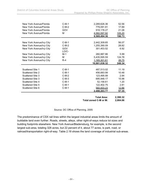
New York Avenue/Florida C-M-1 2,289,626.36 52.56<br />
New York Avenue/Florida C-M-2 779,091.81 17.89<br />
New York Avenue/Florida GOV 918,178.27 21.08<br />
New York Avenue/Florida M 4,582,597.92 105.20<br />
8,569,494.36 196.73<br />
New York Avenue/Ivy City C-M-1 2,442,309.65 56.07<br />
New York Avenue/Ivy City C-M-2 1,255,390.09 28.82<br />
New York Avenue/Ivy City GOV<br />
LO/C-<br />
301,453.52 6.92<br />
New York Avenue/Ivy City<br />
M-1 260,987.86 5.99<br />
New York Avenue/Ivy City M 5,435,595.59 124.78<br />
New York Avenue/Ivy City R-4 1,165,301.61 26.75<br />
10,861,038.32 249.34<br />
Scattered Site 1 C-M-1 487,513.02 11.19<br />
Scattered Site 2 C-M-1 456,683.99 10.48<br />
Scattered Site 3 C-M-2 123,495.99 2.84<br />
Scattered Site 3 C-M-3 695,948.17 15.98<br />
Scattered Site 4 C-M-1 52,156.61 1.20<br />
Scattered Site 5 C-M-1 122,402.75 2.81<br />
Scattered Site 6 C-M-1 560,003.23 12.86<br />
2,498,203.77 57.35<br />
Source: DC Office <strong>of</strong> Planning, 2005<br />
- 51 -<br />
Total Area: 2,390.32<br />
Total zoned C-M or M: 2,004.06<br />
The predominance <strong>of</strong> CSX rail lines within the largest industrial areas limits the amount <strong>of</strong><br />
buildable land even further. Roads, streets, alleys, other right-<strong>of</strong>-ways reduce lot sizes and<br />
building footprints elsewhere. New York Avenue/Bladensburg, for example, is the second<br />
largest sub-area, totaling 328 acres, but 22 percent <strong>of</strong> it, about 77 acres, is park, road, or<br />
railroad/transportation right-<strong>of</strong>-way. Table 2.18 shows the land coverage <strong>of</strong> industrial sub-areas.