Traffic Assessment - Renfrewshire Council
Traffic Assessment - Renfrewshire Council
Traffic Assessment - Renfrewshire Council

Create successful ePaper yourself
Turn your PDF publications into a flip-book with our unique Google optimized e-Paper software.
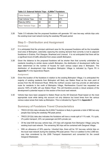
Table 3.5 External Vehicle Trips – 6,000m 2 Foodstore<br />
Table Header In Out Total<br />
Total Vehicle Trips 134 140 273<br />
Pass-by (30%) 40 42 82<br />
‘New’ Vehicle Trips 94 98 191<br />
3.26 Table 3.5 indicates that the proposed foodstore will generate 191 new two-way vehicle trips onto<br />
the existing local road network during the weekday PM peak period.<br />
Step 5 – Distribution and Assignment<br />
Distribution<br />
3.27 It is anticipated that the principal catchment area for the proposed foodstore will be the immediate<br />
local area of Bishopton, ostensibly capturing the existing demand that currently is lost to adjacent<br />
foodstores in Erskine, Port Glasgow, Braehead and Linwood. It is not anticipated that there will be<br />
a significant level of traffic attracted from areas outwith Bishopton.<br />
3.28 Given the distance to the proposed foodstore will be shorter than that currently undertaken by<br />
residents travelling to similar stores outwith Bishopton, the distribution of development traffic has<br />
been determined on the number of houses for each census output area in Bishopton. The<br />
distribution of development trips throughout Bishopton Village is indicated by Figure F8 in<br />
Appendix F in the Appendices Report.<br />
Assignment<br />
3.29 Given the location of the foodstore in relation to the existing Bishopton Village, it is anticipated the<br />
majority of existing residents from Bishopton will likely use Station Road as the main point of<br />
access from the A8 Greenock Road. While the northern access road may provide an alternatives<br />
route for residents in the north of Bishopton Village, <strong>Renfrewshire</strong> <strong>Council</strong> has requested we<br />
assume 100% of traffic will use Station Road. This will therefore provide a robust analysis of the<br />
development’s potential impact on this section of the local road network.<br />
3.30 Vehicle trips have been assigned to Station Road via the A8 Greenock Road based on the most<br />
appropriate route while taking into account not only distance but travel times from the various<br />
census output areas that make up Bishopton. This is indicated by Figure F2 in Appendix F.<br />
Summary of Foodstore Travel Characteristics<br />
• TRICS 2012(b) data indicates the 6,000m 2 foodstore is likely to generate a total of 988 two-way<br />
people trips during the weekday PM peak period;<br />
• TRICS 2012(b) data also indicates the foodstore will have a mode split of 11% walk, 1% cycle,<br />
2% public transport, 23% car passenger and 64% private car;<br />
• Of the total 636 two-way vehicle trips, 273 trips will originate from Bishopton Village using the<br />
existing local road network. The remaining 363 trips will be contained with Dargavel Village;<br />
• With an allowance of 30% pass-by / diverted trips, there will be 191 two-way vehicle trips on<br />
the local road network during the weekday PM peak period. This is in addition to the 2,096 twoway<br />
trips considered by the 2008 Transport <strong>Assessment</strong> and consented for the overall<br />
Dargavel Masterplan.<br />
Job No Report No Issue no Report Name Page<br />
SCT3526 1 1 Dargavel Village<br />
Proposed Village Core Development<br />
15